Sierra de Organos National Park
John Wayne rode through here. So did Kirk Douglas, Burt Lancaster, and a young Chuck Connors in buckskin. From the 1950s through the 1970s, American and Mexican film directors discovered that the towering rock formations of the Sierra de Organos looked exactly like the mythic American West they needed on screen -- only without the permits, the crowds, or the prices. The name comes from the resemblance of these volcanic columns to the pipes of a church organ, but the landscape has served as a stand-in for everywhere from Apache territory to the Alamo. It is a place where geology, wildlife, and Hollywood collide in 11.25 square kilometers of protected Mexican desert.
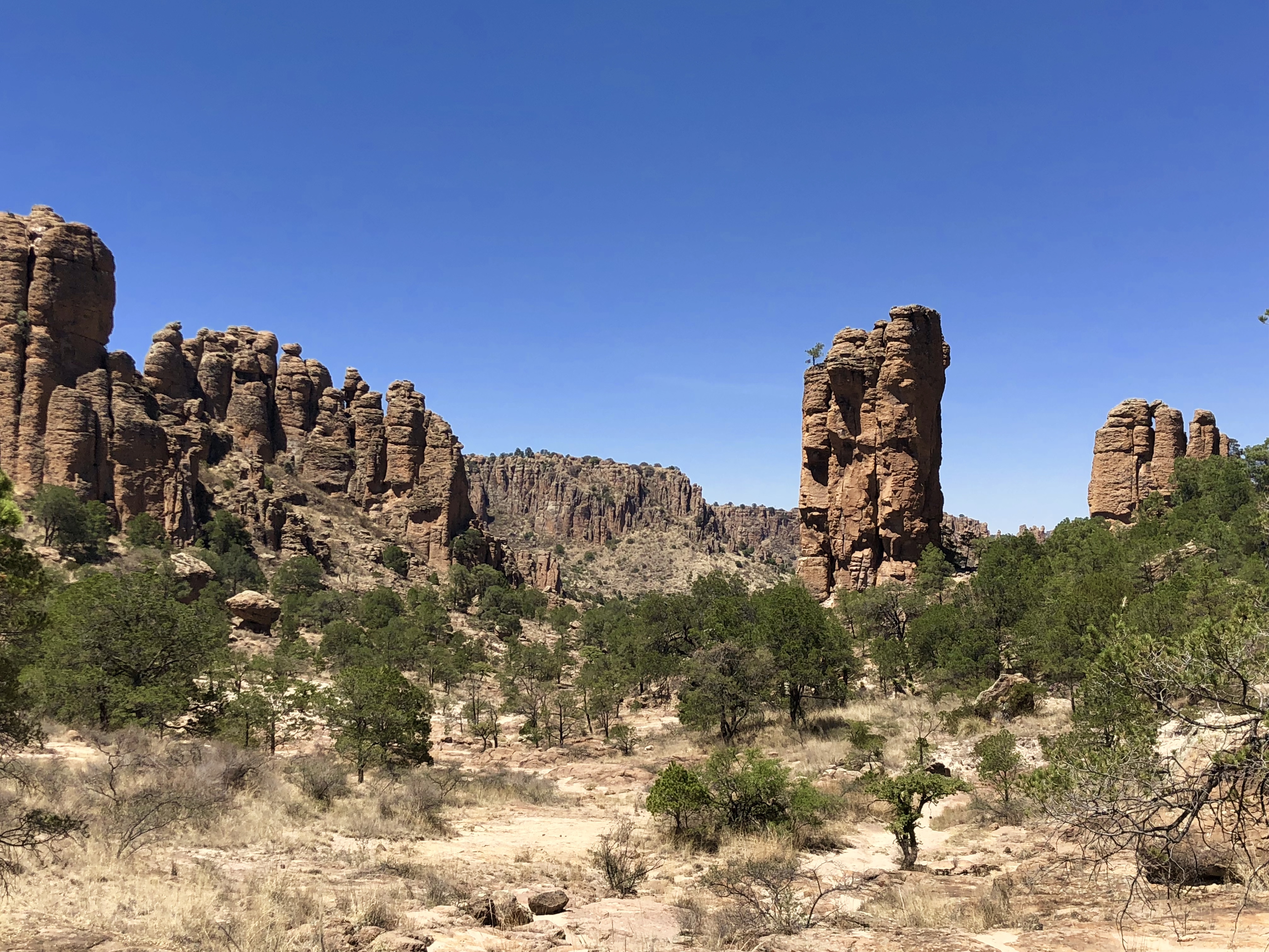
Pipes of Stone
The rock formations that give the park its name are volcanic in origin, columns and spires of rhyolite and ignimbrite sculpted by millions of years of wind and water erosion. Some resemble organ pipes; others suggest castle turrets, standing figures, or the jagged teeth of an enormous jaw. The park sits within the Sierra Madre Occidental mountain range, on the physiographic province of the Mexican Plateau, with elevations ranging from 2,120 meters upward. The landscape shifts dramatically with altitude: xerophilous scrub dominates the lowlands, while conifer forests claim the higher ground. Between these zones, a transitional belt of oak and mixed woodland creates habitat diversity unusual for a park this size.
A Refuge for the Threatened
Sierra de Organos shelters species that have lost ground elsewhere. The cacomixtle -- a ringtail, a small procyonid with enormous eyes and a banded tail -- is endemic to the region and threatened. So is the kit fox, a delicate canid smaller than a house cat. Peregrine falcons hunt from the rock spires. Golden eagles soar above the ridgelines. Cougars, bobcats, and coyotes maintain predator populations, while collared peccaries root through the underbrush and white-tailed deer browse the oak margins. The biodiversity faces pressure from the growing human settlements that surround the park -- agriculture, livestock ranching, and sand mining have degraded some buffer zones -- but the core ecosystems remain largely intact, protected by the park's establishment through federal decree on November 27, 2000.
Hollywood's Mexican Backlot
The film credits read like a western hall of fame. The Tall Men in 1955. The War Wagon and The Scalphunters in the late 1960s. Big Jake and The Train Robbers with John Wayne in the early 1970s. La Cucaracha, a landmark Mexican production in 1959. Even Caveman, a 1981 comedy starring Ringo Starr, used the Sierra de Organos as a prehistoric backdrop. The park's appeal to filmmakers was practical: the rock formations provided dramatic scenery at a fraction of the cost of shooting in the American Southwest, and the Mexican government was accommodating. Kevin Costner's Revenge and the Jimmy Smits vehicle The Cisco Kid continued the tradition into the 1990s. Today the film industry has largely moved on, but the landscape those cameras captured remains unchanged.
Climbing the Organs
For visitors who arrive without cameras and costumes, the park offers rock climbing on its steep spires, hiking trails through the formations, and cycling routes along the lower terrain. Camping is possible but rustic -- most of the park lacks drinking water and basic services, which must be obtained in nearby villages. Access requires a 10-kilometer dirt road from Highway 45, the route connecting Zacatecas with Durango, and a modest entrance fee of 20 pesos. The isolation is part of the appeal. Standing among the stone columns at dusk, with the light turning the rock faces amber and the only sounds the call of a mourning dove and the rustle of a scaled quail in the scrub, it is easy to understand why filmmakers saw a mythic landscape here. The myth was already built into the stone.
From the Air
Sierra de Organos National Park is located at 23.75N, 103.76W in northwestern Zacatecas, approximately 21 km northwest of the city of Sombrerete along Highway 45. The distinctive vertical rock formations are visible from moderate altitudes and resemble organ pipes or castle spires. The nearest airports are General Guadalupe Victoria International (ICAO: MMDO) in Durango, about 90 km to the west, and General Leobardo C. Ruiz International (ICAO: MMZC) in Zacatecas, about 180 km to the southeast. Best viewed at 3,000-5,000 ft AGL. The park covers only 11.25 sq km so precise navigation is needed.