Sierra Madre Occidental
The name means "Western Mother Mountain Range," and the maternal metaphor fits. The Sierra Madre Occidental cradles entire civilizations in its folds. The Tarahumara run its canyon trails. The Huichol conduct peyote pilgrimages across its southern slopes. The Tepehuanes farm its eastern flanks. From the Arizona border to central Mexico, this 1,250-kilometer spine of volcanic rock forms the western backbone of the continent, channeling rivers westward into the Gulf of California and eastward into the interior deserts, separating climates and cultures as decisively as any ocean.
Built by Fire
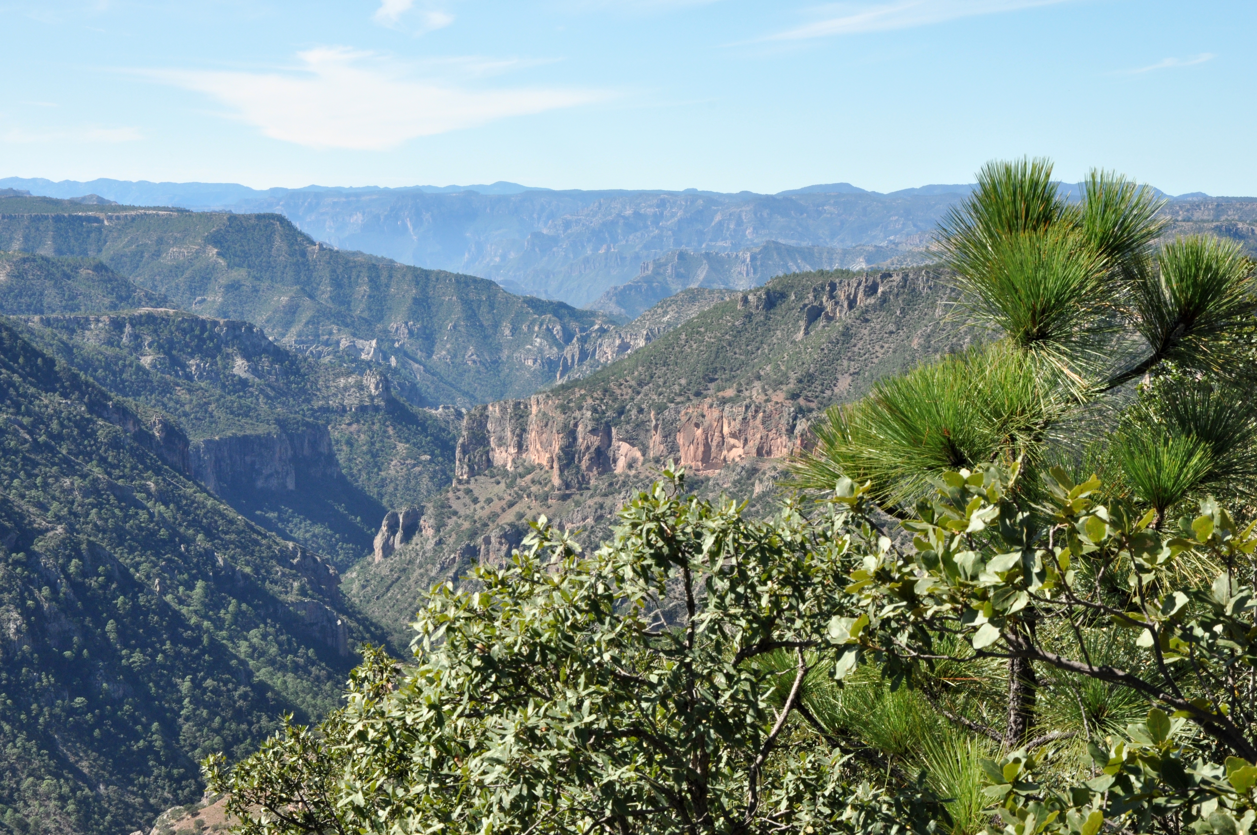
The Sierra Madre Occidental is not one range but a vast volcanic plateau, the largest continuous block of ignimbrite -- volcanic ash compressed into rock -- on Earth. Eruptions during the mid-Tertiary period blanketed the region in sheets of silica-rich tuff that subsequent erosion carved into the dramatic canyons and peaks visible today. The range stretches from northern Sonora southeast through Chihuahua, Sinaloa, Durango, Zacatecas, Nayarit, and Jalisco before meeting the Trans-Mexican Volcanic Belt. Its highest peaks exceed 3,000 meters. On the western side, rivers have cut canyons deeper than the Grand Canyon, including the system known as Barrancas del Cobre -- Copper Canyon -- where the vertical drop from rim to river bottom exceeds 1,800 meters in places.
Vertical Worlds
Elevation governs everything here. Above 2,400 meters, Mexican Douglas-fir and Chihuahua spruce forests shelter Mexican spotted owls and thick-billed parrots. Between 1,200 and 2,400 meters, vast pine-oak woodlands blanket the slopes, one of the most biodiverse temperate forest types on the planet. Below the canyon rims, the vegetation shifts through subtropical deciduous forest to near-tropical conditions at the river bottoms, where figs and palms grow in air thick with humidity. A single day's hike can pass through climate zones that would take thousands of kilometers to traverse at sea level. The range runs parallel to the Pacific coast, its western slopes catching moisture from the Gulf of California while its eastern flanks descend into the dry interior plateau.
People of the Canyons
The Tarahumara, who call themselves Raramuri, have inhabited the central Sierra Madre for centuries. Their name may derive from a word meaning "the running people," and their endurance running over canyon terrain has drawn international attention and scientific study. To the south, the Huichol maintain one of the most intact indigenous cultures in Mexico, centered on annual pilgrimages from the Sierra Madre to the desert of San Luis Potosi. The Tepehuanes, both northern and southern groups, occupy the eastern slopes. Before the Spanish arrived, the Chalchihuites culture had farmed the range's margins for over a millennium. All of these peoples adapted to the sierra's verticality, moving seasonally between elevations as climate and resources demanded.
Silver, Timber, and the Costs of Extraction
Spanish colonizers followed silver into the Sierra Madre in the 17th century, establishing mining centers at Alamos, Batopilas, and dozens of smaller camps. The silver economy transformed the range from an indigenous homeland into a colonial frontier. Centuries later, commercial logging stripped vast stretches of old-growth forest. Approximately two percent of the original old-growth remains. The imperial woodpecker, once the world's largest, went extinct here. The Mexican wolf was driven to the brink. Mining continues to pollute rivers and disrupt aquifers. Drug cultivation and trafficking have brought violence to remote communities that the road system barely reaches. The Sierra Madre's inaccessibility, which for centuries protected its cultures and ecosystems, now complicates every effort at enforcement and conservation.
The Range Endures
Despite the pressures, the Sierra Madre Occidental remains one of North America's great wild landscapes. Its canyons harbor species found nowhere else. Its forests, though diminished, still constitute one of the largest remaining stands of temperate woodland in Mexico. The rivers that drain its western slopes -- the Fuerte, the Mayo, the Yaqui -- sustain agriculture and communities across the coastal lowlands of Sonora and Sinaloa. Conservation efforts are growing, though enforcement remains underfunded. The range itself is indifferent to these human dramas. It was built by volcanic eruptions on a scale difficult to comprehend, and it will outlast the mines, the logging roads, and the arguments about its future. The Mother Mountain Range keeps its own counsel.
From the Air
Centered at approximately 26.75N, 108.06W, the Sierra Madre Occidental runs 1,250 km from the Arizona-Sonora border to central Mexico. From cruising altitude, the range appears as a massive elevated plateau deeply incised by canyons, particularly on the western side. The Copper Canyon system (Barrancas del Cobre) is visible as a dramatic network of gorges southwest of Chihuahua city. Major airports in the region include Chihuahua (MMCU), Culiacan (MMCL), Mazatlan (MMZT), and Los Mochis (MMLM). The Chepe railroad route through Copper Canyon is sometimes visible as a thin line threading through the canyons. Best appreciated at cruising altitude for the full scope of the range, or at 5,000-10,000 feet AGL for canyon detail.