Similan Islands
The word "Similan" comes from the Yawi language and means nine. When the archipelago was first named, only nine islands counted. Two more were added to the national park in 1998, but the old name stuck -- a reminder that places often outgrow the words we use for them. Seventy kilometers off the coast of Phang Nga Province in Thailand's Andaman Sea, the Similan Islands sit at the maritime border between India and Thailand, an eleven-island chain where granite boulders tumble into water so clear that divers can see the coral sixty feet below before they even submerge. Established as Mu Ko Similan National Park in 1982, this archipelago has become one of the world's premier dive destinations. It has also become a cautionary tale about what popularity costs.
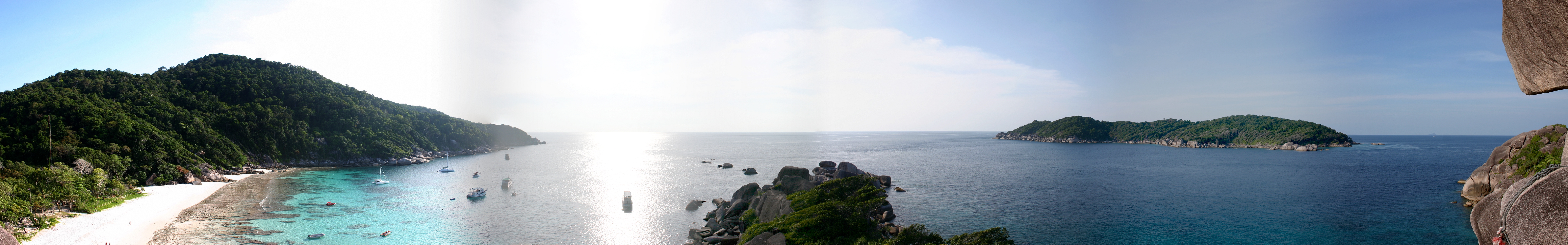
Numbered Islands, Uncountable Life
The Thai Department of National Parks assigned each island a number, running from south to north: Ko Huyong (Island 1) through Ko Tachai (Island 11). The system is practical but stripped of poetry. Ko Similan, Island 8, is the largest, and its surrounding waters average sixty feet deep -- a realm of rock formations and coral reefs shaped like brains, mushrooms, and branching antlers. Above the waterline, Nicobar pigeons strut through the undergrowth, mangrove monitor lizards patrol the shores, and flying foxes hang from the canopy at dusk. Ko Huyong boasts the park's longest and widest beach, but no tourist will ever set foot on it: the island is closed to visitors because sea turtles use that sand to lay their eggs. Islands 1, 2, and 3 are all restricted to protect nesting turtles and recovering reefs. Island 3 is privately owned by a member of the Thai royal family.
Too Many Footprints in the Sand
By 2017, Mu Ko Similan National Park was receiving approximately 912,000 tourists per year. During peak season, from mid-October to mid-May, five to six thousand visitors arrived daily -- and on busy days, the number pushed past seven thousand. The coral showed the strain. Environmental degradation prompted the Department of National Parks to act. Ko Tachai, Island 11, was closed indefinitely to tourists in October 2016 to allow its ecosystems to recover. When the park reopened in October 2018, a daily visitor cap of 3,850 was imposed -- roughly half the previous average. All overnight accommodations on the islands were removed. Tour operators protested, citing potential job losses, but the park authorities held firm. The annual closure during the rainy season, from May 16 to October 15, now serves as both a weather precaution and a biological reprieve, giving reefs and beaches months to regenerate without the pressure of human feet and anchor chains.
Nets in the Reef
Fishing is officially prohibited throughout both the Similan and Surin National Parks. The prohibition exists on paper; the water tells a different story. Divers regularly encounter fishing nets tangled in the reefs and illegal traps scattered across the seabed, particularly outside the most-visited dive sites where enforcement is thin. The traps capture trevallies, batfish, barracuda, golden pilot jacks, and triggerfish -- species that belong to the reef ecosystem, not a market stall. The waters around Ko Bon and Ko Tachai have been identified as especially problematic, with a higher prevalence of illegal fishing equipment discovered in recent years. Meanwhile, BirdLife International has designated the archipelago an Important Bird Area because it supports a population of vulnerable pale-capped pigeons. Protection, it turns out, requires more than drawing lines on a map. It requires watching those lines constantly.
The Wave That Changed Everything
On December 26, 2004, the Indian Ocean tsunami struck the Similan Islands with devastating force. Scuba divers underwater at the time reported being caught suddenly in violent, swirling currents that tossed them through the water column. On land, camcorder footage captured the wave surging inland, flooding campsites and sweeping away equipment. The damage to the islands was severe -- both above and below the waterline. Coral formations that had taken centuries to grow were shattered in minutes. The tsunami became a dividing line in the park's history: before 2004, the Similans were a remote diving paradise with relatively little infrastructure; afterward, the rebuilding process forced a reckoning with how much development the islands could sustain. The visitor caps and accommodation removals that followed years later were, in part, a delayed answer to the question the wave had posed -- how much human presence can these islands bear?
From the Air
The Similan Islands are located at approximately 8.65N, 97.64E in the Andaman Sea, 70 km off the coast of Phang Nga Province in southern Thailand. The eleven-island chain runs roughly north-south and is clearly visible from cruising altitude as dark green dots against the turquoise Andaman waters. Access point is Tab Lamu Port near Khao Lak on the mainland. Nearest major airport is Phuket International Airport (VTSP), approximately 100 km to the southeast. Ranong Airport (VTSR) is to the north. Best viewed at 5,000-8,000 ft to see the full archipelago spread and the contrast between the deep Andaman blue and the shallow turquoise around each island. The islands mark the India-Thailand maritime border.