Skocjan Caves
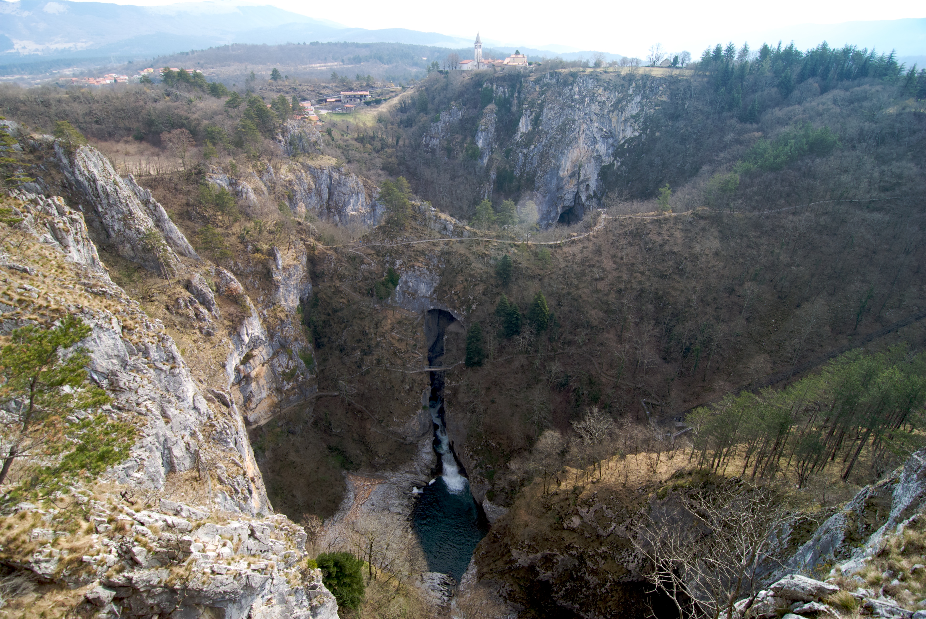
The Reka River flows through the Slovenian countryside like any ordinary waterway -- until it reaches the edge of the Karst plateau and drops into a sinkhole so enormous it has its own name: the Big Collapse Doline. From there, the river vanishes. It will not see daylight again for 34 kilometers, resurfacing near the Italian town of Monfalcone to feed the Timavo River on its final two-kilometer run to the Adriatic Sea. What happens in between -- the underground canyon, the cathedral-sized chambers, the passages that took explorers over a century to map -- is the Skocjan Caves, a UNESCO World Heritage Site since 1986 and the reason the word "karst" exists in every geological textbook on Earth.
The River Beneath
The numbers alone are staggering. The explored cave system runs for 6,200 meters through a 300-meter layer of Cretaceous and Paleocene limestone. The underground channel that follows the river is approximately 3.5 kilometers long, 10 meters wide in places, and over 140 meters high. At certain points it expands into enormous chambers, the largest being Martel's Chamber, with a volume of 2.2 million cubic meters -- the biggest discovered underground chamber in Europe and among the largest anywhere in the world. The canyon ends at a siphon too small to handle the volume of water during heavy rainfall, which means flood levels inside the caves can rise by more than 100 meters. The river that carved this system contributes roughly one-third of the Timavo's flow when it finally resurfaces near the Adriatic coast.
Known Since Antiquity
People have been writing about the Skocjan Caves for over two thousand years. The Greek philosopher Posidonius of Apamea described them in the second century B.C. They appear on the Lazius-Ortelius map of 1561 and in Mercator's Novus Atlas of 1637. In 1689, the Carniolan polymath Johann Weikhard von Valvasor documented the Reka River's disappearance and its underground course. A century later, the French painter Louis-Francois Cassas was commissioned to paint the landscape around the Big Collapse Doline, recording for European audiences a natural wonder that residents of the Karst plateau had known for millennia. The caves were significant enough that explorers attempted to follow the Reka's underground path in hopes of supplying Trieste with drinking water -- a practical ambition that opened the door to systematic exploration.
Into the Dark
The first organized speleological expedition entered the caves in 1884. Six years later, explorers reached the banks of Mrtvo jezero -- Dead Lake -- a still, dark pool deep inside the system. In 1904, local men achieved what had seemed impossible: they climbed the sixty-meter wall of Muller Hall to discover Silent Cave, opening an entirely new section of the system. Then progress stalled. Nearly a century passed before the next major breakthrough, when Slovenian divers swam through the Ledeni dihnik siphon in 1990 and discovered over 200 meters of previously unknown passages. Each generation of explorers pushed a little farther into the dark, and the caves rewarded them with scale that defied expectation.
Walking the Underground Canyon
Tourism at Skocjan began remarkably early. In 1819, a county councilor named Matej Tominc ordered the construction of steps leading down to the Big Collapse Doline, completed by 1823. A visitors' book was introduced on January 1, 1819, marking the formal start of organized tourism. The first cave sections opened to the public by 1933, though a devastating flood in 1965 caused severe damage that took decades to repair. The area was renovated in 2011 with the addition of a new steel bridge, and today approximately 100,000 visitors walk through the caves each year. Guided tours in Slovenian, English, Italian, and German take visitors through the underground canyon to the Big Collapse Doline. The experience is less polished than the more famous Postojna Cave nearby, but the raw scale of the chambers and the roar of the river through the canyon make Skocjan feel genuinely wild.
The Karst from Above
From the air, the Karst plateau appears as a pale, rolling limestone upland pocked with sinkholes and covered in scrubby Mediterranean vegetation. The Big Collapse Doline is visible as a dramatic gash in the surface, its walls plunging to where the Reka River disappears. Slovenia established the Skocjan Caves Regional Park after independence from Yugoslavia in 1991, and the area was designated a Ramsar wetland of international importance in 1999. The cave system sits just a few kilometers from the Italian border and the suburbs of Trieste, an extraordinary natural monument hidden beneath an unremarkable landscape. The contrast between the placid surface and the immense void below is the essential fact of karst country, and Skocjan is its most dramatic expression.
From the Air
Located at 45.67N, 13.99E on the Karst plateau in southwestern Slovenia, just a few kilometers from the Italian border. The Big Collapse Doline is visible from the air as a large sinkhole depression. Recommended viewing altitude: 3,000-5,000 feet to see the doline features and surrounding karst terrain. Nearest airports: Trieste-Friuli Venezia Giulia Airport (LIPQ) approximately 30 km west, and Portoroz Airport (LJPZ) approximately 25 km south. The Karst plateau's distinctive pale limestone landscape with scattered sinkholes is identifiable from moderate altitude.