Sleeping Bear Dunes National Lakeshore
According to Chippewa legend, a mother bear and her two cubs plunged into Lake Michigan to escape a wildfire raging on the far shore. The mother reached safety, exhausted, and turned to watch for her children. They never arrived. The Great Spirit Manitou transformed the waiting mother into a massive sand dune facing the lake, and the two cubs into North and South Manitou Islands, forever just out of reach. The Sleeping Bear Dunes National Lakeshore preserves this landscape of loss and endurance along 35 miles of Michigan's northwestern coast, where dunes rise 450 feet above the water and the wind never stops reshaping the sand.
Sand Sculpted by Deep Time
The dunes owe their existence to glaciers, not legend. As the ice sheets retreated thousands of years ago, they left behind ridges of debris that became the spine of the Manitou Islands and the bluffs along the mainland shore. Wind and water took over from there, pushing sand into towering formations that continue to shift and grow. The mainland park stretches across three sections separated by the villages of Empire and Glen Arbor, with the Platte River emptying into Lake Michigan at the southern end and several small inland lakes scattered through the interior. North Manitou Island, roughly eight miles by four, features 400-foot sand dunes in its northwest corner. South Manitou, smaller and rounder, holds perched dunes on its western face and a wide, concave harbor to the east.
Where the Forest Meets the Sand
The vegetation tells a story of determination. Dune grasses send long roots deep into the sand, anchoring the shifting surface alongside thistles and bearberries. Juniper and jack pine gain footholds in the drier stretches. Move slightly inland and oak and white pine appear. Further still, where the soil grows richer, a beech and maple hardwood forest takes over, with hemlock, basswood, and black cherry filling in the canopy. On South Manitou Island, where deer were never introduced and farming never took hold, the forest preserves a version of what the mainland looked like before settlement. Stands of white cedar grow there, one fallen specimen measured at over 500 years old. Trillium, orchids, and spring wildflowers carpet both islands. The endangered piping plover nests on North Manitou's shoreline, closing parts of the beach during mating season.
Ghosts of the Lakeshore
Before it became a National Lakeshore, this stretch of coast was a critical waypoint for Great Lakes shipping in the 19th century, one of the few large safe harbors on the route around the Lower Peninsula to Chicago. Farmers worked the land both for subsistence and to supply passing ships. The evidence remains scattered across the park: Port Oneida Farms in the northern section and Tweedle and Treat Farms to the south are well-preserved 19th-century settlements, their buildings in varying states of picturesque disrepair rather than restoration. On North Manitou Island, a row of former homes and cottages known simply as The Village sits near the dock, long abandoned, slowly surrendering to weather and time. The National Lakeshore was assembled in the 1960s and 1970s, largely from private land, and the process was not without controversy.
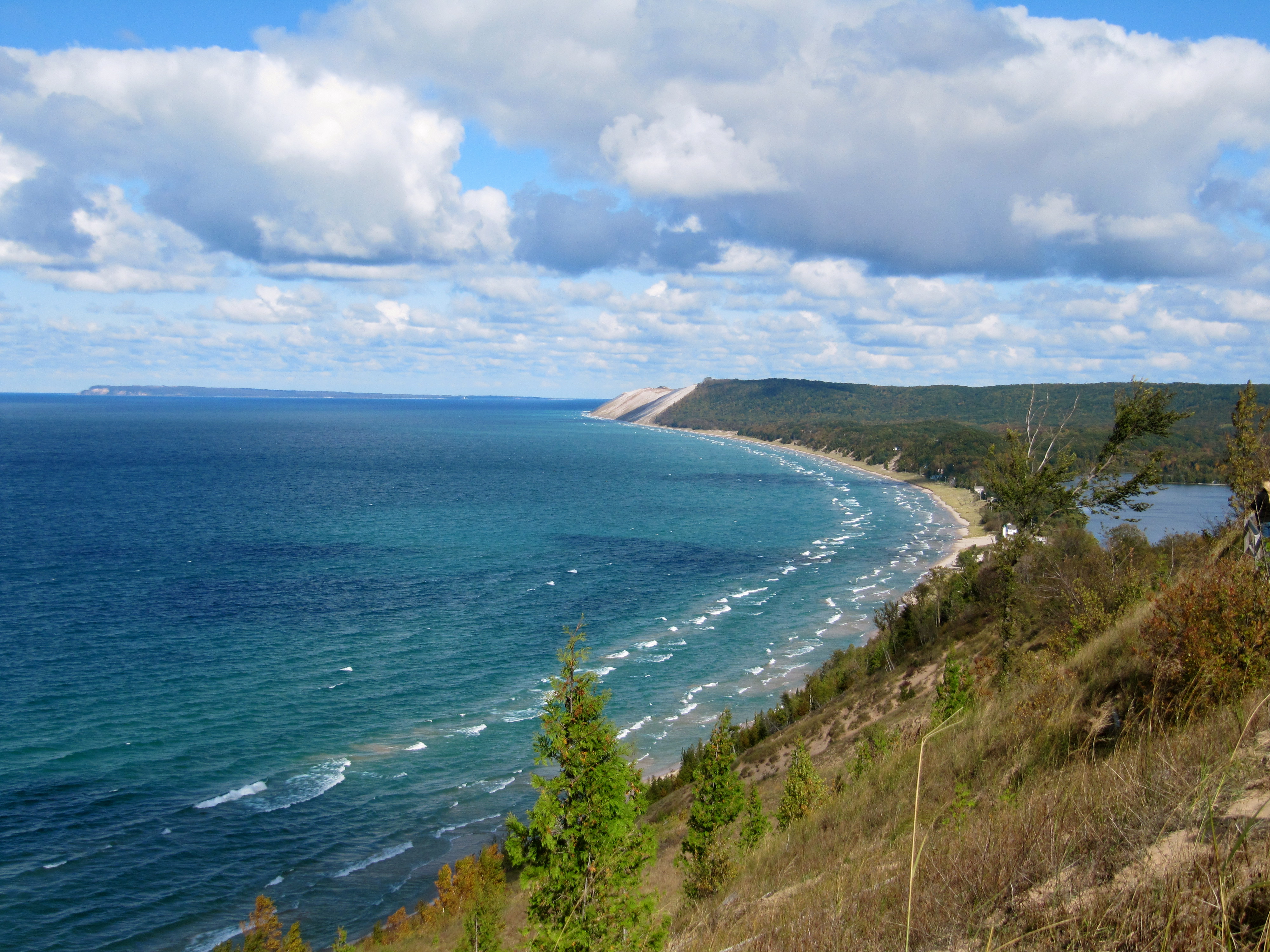
The Climb
The dune near Sleeping Bear Point at the center of the park is the main attraction, and it earns its reputation. The climb is not technical, but it is steep, a relentless uphill slog through loose sand that rewards anyone in decent physical condition with a view that stretches across Lake Michigan to the Manitou Islands. Over a dozen hiking and cross-country ski trails totaling 55 miles wind through the park, from the Cottonwood Trail where rangers lead summer nature walks to Alligator Hill where horseback riding is permitted. In winter, park rangers lead snowshoe hikes on weekends through January and February, two-hour treks starting from the visitor center. Despite its name, the park rarely sees actual bears. The wildlife runs more to chipmunks, foxes, bald eagles on the islands, and the occasional bobcat that avoids human contact entirely.
Where Lake Michigan Rules
Sitting precisely at 45 degrees north latitude, halfway between the pole and the equator, the park lives at the mercy of the lake. Summers push past 90 degrees with heavy humidity drawn off the water. Winters drop below zero with heavy snowfall. The vast reservoir of Lake Michigan moderates nothing so much as it amplifies: heat becomes muggy, cold becomes snowy, and weather changes arrive fast off the open water. The lake shapes the dunes, feeds the forests, and defines the experience. To the northeast lies the Leelanau Peninsula wine region. To the east, Traverse City, Michigan's cherry capital, sits on Grand Traverse Bay. The park's nearest commercial airport, Cherry Capital Airport, connects to Detroit and Chicago, but the real approach is along M-72 west to Empire, then M-22 north through some of the most scenic roadway in the Midwest.
From the Air
Sleeping Bear Dunes National Lakeshore (44.91N, -86.02W) stretches along 35 miles of Lake Michigan's eastern shore, visible as a dramatic band of pale sand against dark forested bluffs and blue water. From cruising altitude, the North and South Manitou Islands are clearly visible 6-7 miles offshore. Best viewed from 3,000-5,000 feet, where the contrast between dune sand, forest, and water is most striking. Cherry Capital Airport (KTVC) in Traverse City lies approximately 30 miles to the east. The Leelanau Peninsula juts north beyond the park, a distinctive finger of land extending into Lake Michigan.