Smith Island (Washington)
The lighthouse stood 200 feet from the western bluff when it was built in 1858. By the 1950s, erosion had brought the cliff to the front door, and the keepers walked away. For nearly two more decades the ruin clung to the crumbling edge, a slow-motion collapse that ended in the spring of 1998 when the last stones finally let go. Smith Island, a low grass-and-rock platform in the eastern Strait of Juan de Fuca, has been losing ground to the sea for as long as anyone has watched. What remains belongs to the birds.
Isla de Bonilla
Spanish navigator Jose Maria Narvaez was the first European to chart the island, in 1791, naming it Isla de Bonilla. Hudson's Bay Company traders renamed it Smith Island sometime in the first half of the 19th century, though exactly which Smith they honored has been lost to history. The island sits roughly midway between Admiralty Inlet and Lopez Island, a geographic position that made it a natural landmark for mariners navigating the tricky confluence of the Strait of Juan de Fuca and Puget Sound. Getting there requires the longest open-water crossing in Washington State. The nearest landfall is Whidbey Island, approximately four nautical miles distant -- a significant stretch of exposed sea where currents and weather can turn dangerous without warning.
The Light That Fell
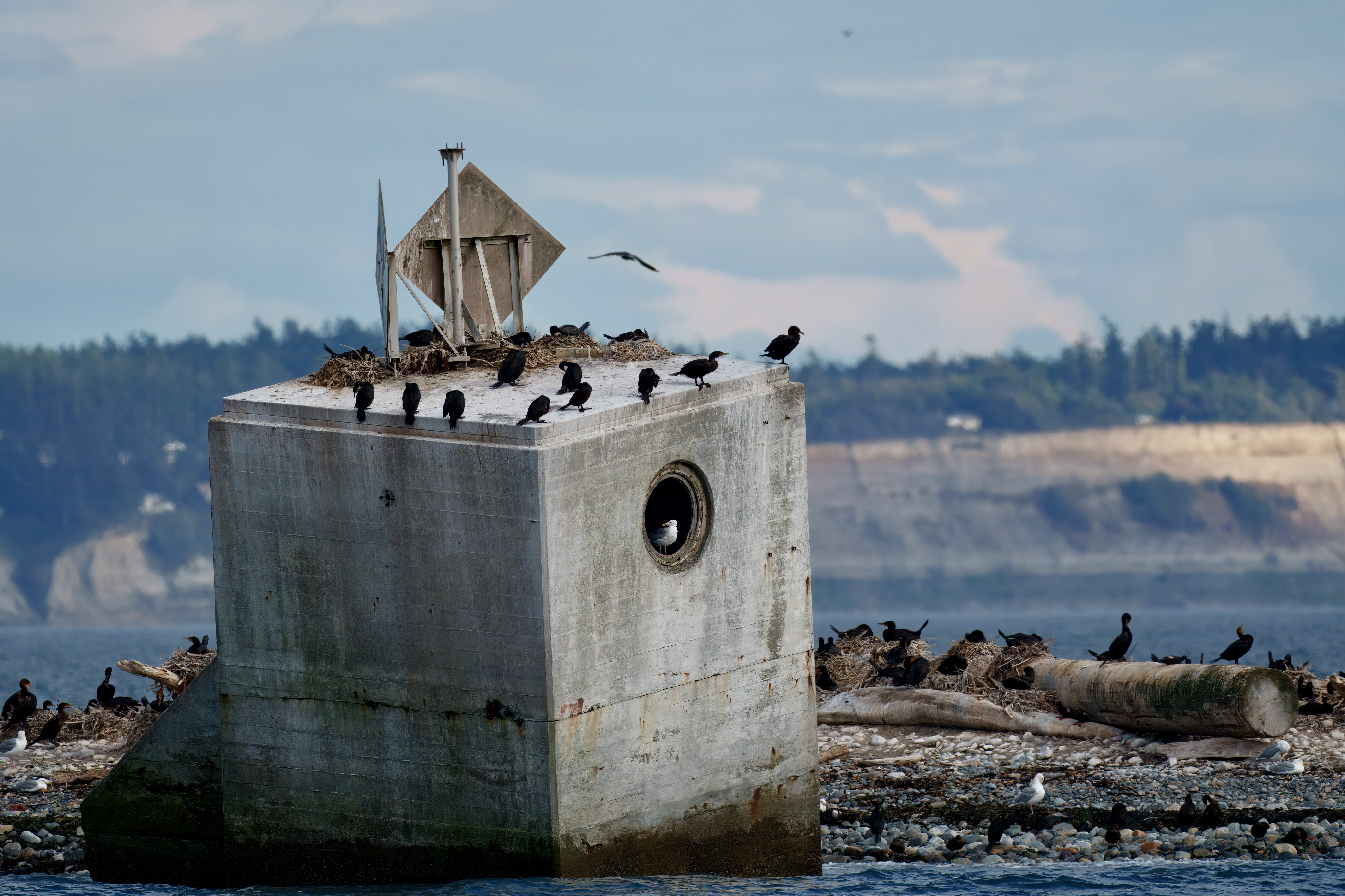
The Smith Island Light was one of the earliest navigational aids on the inland waters of Washington. Constructed in 1858, it guided vessels through the strait for nearly a century. But the island's western bluff was retreating steadily, carved away by winter storms and tidal surges. When the erosion reached the lighthouse in the 1950s, the structure was abandoned. An automated navigational light, 97 feet tall, replaced it. Minor Island, the small companion islet connected to Smith by a low spit that vanishes at high tide, received its own light as well. The old lighthouse, meanwhile, became a ruin in slow motion. Photographs from the 1980s and 1990s show it listing and fragmenting, a brick skeleton perched on the edge of nothing. By 1998 it was gone, swallowed by the sea it had spent a century trying to warn sailors about.
A Kingdom of Wings and Whiskers
Today Smith and Minor Islands are part of the San Juan Islands National Wildlife Refuge, and they are almost always closed to the public. The restriction exists for good reason. The low, grassy terrain and rocky beaches provide critical habitat for nesting seabirds -- gulls, cormorants, murres, and pigeon guillemots wheel above the old Coast Guard station in dense, noisy clouds. The beaches serve as haul-out sites for Steller and California sea lions, which bask on the rocks in numbers that vary with the season. NOAA operates a weather station on the island, one of the few signs of ongoing human activity in a place that has otherwise been ceded to wildlife. The isolation that once justified a lighthouse now justifies the opposite: keeping people away so the colonies can thrive undisturbed.
From the Air
Located at 48.32N, 122.84W in the eastern Strait of Juan de Fuca. Smith Island appears as a low, flat landmass with a companion islet (Minor Island) connected by a tidal spit. The automated light tower is the most prominent vertical feature. Nearest airports: KNUW (NAS Whidbey Island) approximately 7 nm east, and W33 (Friday Harbor) approximately 14 nm north. Recommended viewing altitude 1,000-2,000 ft AGL. Watch for bird activity visible as white speckling on the island surface.