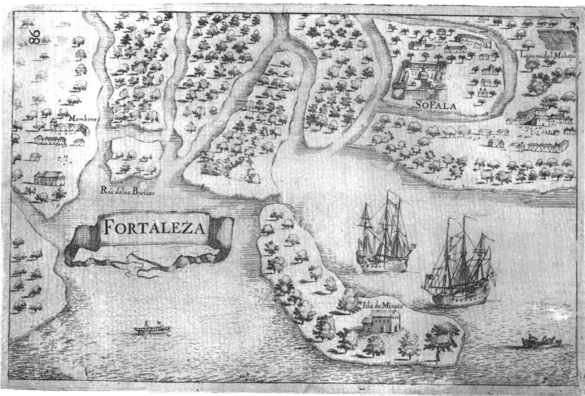
Sofala
The name may derive from Somali words meaning "go and dig" — an instruction, an invitation, a command. For centuries, that is exactly what people did. Mogadishan merchants arrived first, sometime in the tenth century, drawn by gold flowing from the interior kingdoms of Great Zimbabwe down the Buzi River to a mangrove-choked estuary on the southern Mozambican coast. They kept the location secret from their Kilwan rivals, who rarely sailed south of Cape Delgado. The secret held for two hundred years. When it finally broke, Sofala became the most powerful coastal city in southern East Africa, a place so wealthy that Portuguese chroniclers mistook it for the biblical Ophir — the legendary source of King Solomon's gold.
Gold River
Sofala's power was geographical. The Buzi River connected the port to the inland market town of Manica, and from Manica, trade routes led to the gold fields of Great Zimbabwe. Swahili merchants strengthened this artery by sending river-going dhows up the Buzi and Save rivers to ferry extracted gold to the coast, where it entered the broader Indian Ocean trade network. In the 1180s, Sultan Suleiman Hassan of Kilwa seized control of Sofala and brought it into the Kilwa Sultanate and the Swahili cultural sphere. But Sofala was never a mere outpost. It maintained its own internal elite, its own merchant communities, and trade connections stretching as far south as Cape Correntes and across the Mozambique Channel to Madagascar. The Sultan of Kilwa's governor in Sofala functioned more as a consul than a ruler — the city could be, as one account notes, "quite prickly" when Kilwa tried to interfere in its affairs.
The Spy Who Walked In
In 1489, a Portuguese explorer named Pêro da Covilhã arrived in Sofala disguised as an Arab merchant. He was a spy, sent overland by the Portuguese crown to identify the sources of East African gold. His secret report to Lisbon confirmed Sofala's role as a gold emporium, though by then the trade had already diminished from its peak. A decade later, Portuguese ships appeared offshore. In 1502, Pedro Afonso de Aguiar — or possibly Vasco da Gama himself, sources disagree — sailed into the harbor and sought an audience with Sheikh Isuf, Sofala's ruling elder. Isuf was already at odds with Kilwa, whose legitimate sultan had been murdered and replaced by a usurper. The Portuguese, with their powerful ships, offered Isuf a way to break free of Kilwa's influence. He agreed to a commercial and alliance treaty with the Kingdom of Portugal. In 1505, Pêro de Anaia was granted permission to build Fort São Caetano near the city — the second Portuguese fort in East Africa, constructed with stone imported from Europe.
Malaria and Shifting Sands
The Portuguese fort did not last long. Malaria decimated the garrison within months. In late 1507, the new captain of Sofala, Vasco Gomes de Abreu, captured Mozambique Island to the north and began transferring operations there. Sofala's decline was not just medical — it was geological. The entrance to the estuary was blocked by a long, shifting sandbank followed by hazardous shoals, allowing boats to approach safely only at high tide. The shores were mangrove swamp, thick with stagnant water and mosquitoes. As a harbor, it was deeply unsuitable for Portuguese ships, which is why they were quick to make Mozambique Island their preferred anchorage. The old gold fields were largely exhausted by the time the Europeans arrived, and production had moved further north to market towns along the Zambezi escarpment, where Quelimane and Angoche were more convenient outlets. Sofala's commercial relevance faded, though colonial governors of Portuguese Mozambique would continue to carry "Captain of Sofala" as their primary official title for generations — a prestige inherited from a port that no longer mattered.
A City the Ocean Took Back
In its heyday, Sofala was actually two towns: one built on a sand flat near the water, the other on higher, healthier ground inland. A satellite settlement stood to the north at the mouth of the Pungwe River, recorded on old maps as Rio de São Vicente. The harbor was once reputed to hold a hundred vessels. None of this remains. The shifting sands and boundaries of the Buzi estuary have allowed the sea to reclaim much of old Sofala. Deforestation along the river's banks accelerated the silting that choked the harbor. When the modern city of Beira was established twenty miles to the north in 1890 — built on the site of Sofala's old satellite settlement — whatever commercial role Sofala still held evaporated. Today, the village known as Nova Sofala offers almost no ruins to suggest its former grandeur. The gold is gone, the harbor is mud, and the city that Portuguese chroniclers once compared to the treasuries of Solomon has been erased by the same estuary that made it rich.
From the Air
Sofala (Nova Sofala) is located at approximately 20.15°S, 34.72°E on the Sofala Bank coastline of central Mozambique, at the mouth of the Buzi River estuary. From altitude, the area appears as a low-lying coastal plain with extensive mangrove swamps and river channels. The city of Beira is visible roughly 20 miles to the north, built on the site of Sofala's former satellite settlement. Beira Airport (FQBR) is the nearest major facility. The estuary has silted significantly, and the shallow, shifting sandbanks that plagued historical navigation are visible at low tide. The Sofala Bank extends offshore as a wide, shallow continental shelf. Visibility is generally good in the dry season but tropical cyclones pose a risk.