Sol de Mañana
Steam eruptions here have, under exceptional circumstances, reached 200 meters -- tall enough to be spotted from space on thermal satellite imagery. Sol de Mañana sits at approximately 4,900 meters elevation in southern Bolivia's Sud Lipez Province, in a region so remote that the nearest communities, Quetena Grande and Quetena Chico, lie 75 kilometers to the northeast. The field can only be reached by unpaved roads from Uyuni, 340 kilometers away. It is one of the highest geothermal fields in the world, and one of the most spectacularly inhospitable.
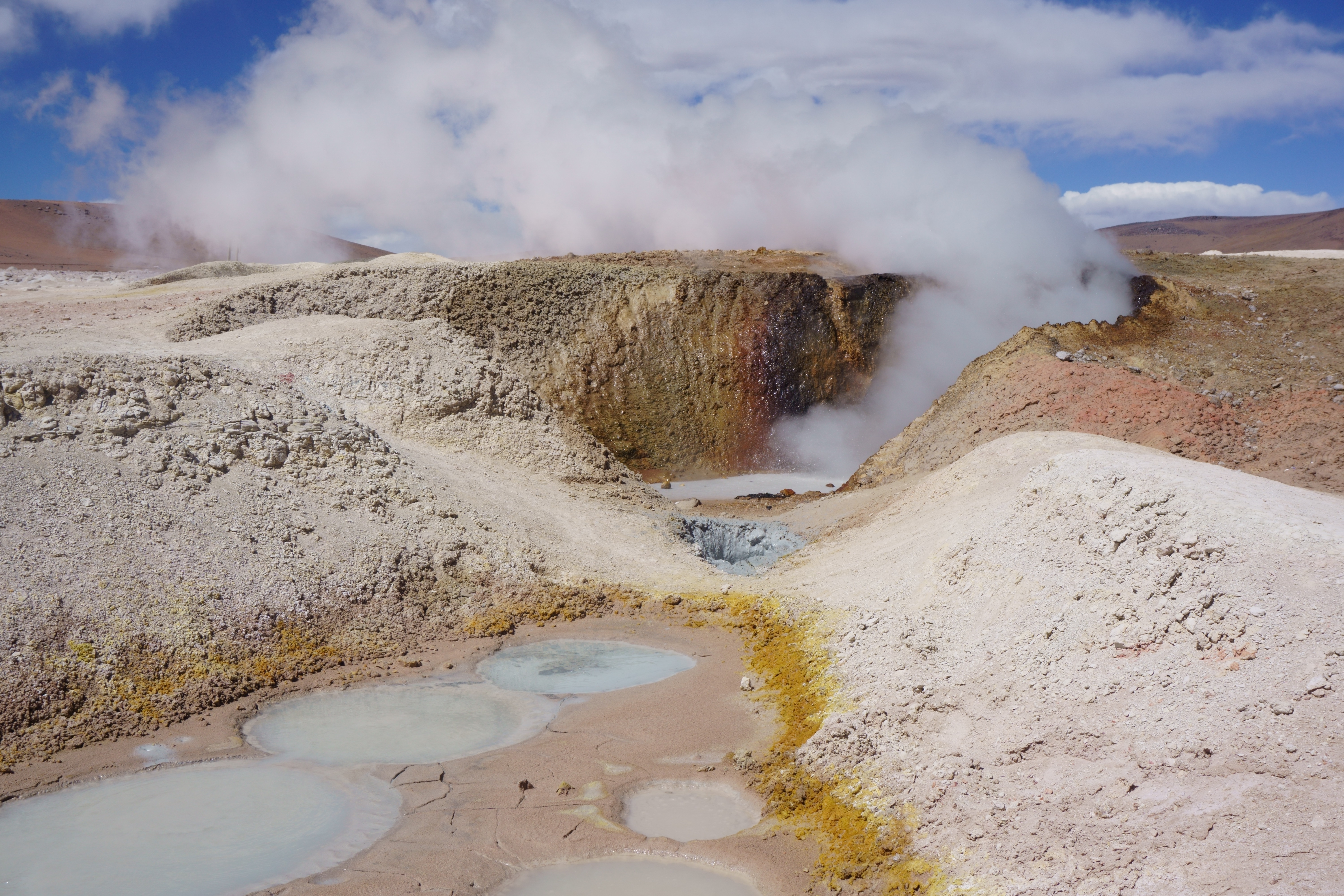
Fire and Sulfur on the Roof of the World
Across ten square kilometers of barren altiplano, Sol de Mañana presents nearly every form of geothermal expression the Earth can produce: steam vents, mud pools, hot springs, geysers, and fumaroles. Gas vents release sulfur-laden compounds that stain the surrounding rock in shades of yellow and orange. The springs reach temperatures of 30 degrees Celsius, while fumaroles hit 70 degrees -- hot enough to register as bright spots on ASTER satellite sensors. Seismic swarms and small earthquakes have been recorded in the field, reminders that the ground here is anything but stable. Additional geothermal features extend a few kilometers south-southwest at Apacheta and twelve kilometers north-northwest at Huayllajara, both sites of hydrothermally altered rock that some geologists classify as separate fields entirely.
Plumbing the Magma Body
The heat beneath Sol de Mañana comes from deep within the Andes. The Nazca Plate, diving beneath the South American Plate off the Pacific coast, drives the volcanism that built the Altiplano over the past 25 million years. Sol de Mañana sits within the Andean Central Volcanic Zone, one of four volcanic belts in the range, above the Altiplano-Puna Magma Body -- a vast reservoir of partially molten rock that underlies much of the high plateau. Drill cores have revealed several layers of dacitic ignimbrites between five and 1.2 million years old, along with andesitic lavas, all hydrothermally altered into thick bands of clay, silica, and epidote. Two underground heat reservoirs, capped by clay layers, hold water at temperatures around 250 degrees Celsius. Precipitation seeps down through deep faults to reach them, and the same faults channel heat upward to the surface.
A Twin Across the Border
Thirty kilometers to the west, across the Chilean frontier, lies El Tatio -- the best-known geothermal field in the Central Andes and a major tourist destination. The two fields share more than proximity. Drill core stratigraphy at Sol de Mañana closely mirrors what has been found at El Tatio, and geologists suspect the two systems may be physically connected underground, with Sol de Mañana sitting closer to the heat source and El Tatio functioning as an outflow at lower elevation. The surrounding landscape reinforces the volcanic kinship: Tocorpuri, Putana, and Escalante volcanoes rise to the southwest, while the Pastos Grandes and Cerro Guacha caldera systems sprawl nearby. Laguna Colorada, the crimson salt lake famous for its flamingo colonies, lies just 20 to 40 kilometers to the north.
The Long Road to Geothermal Power
The 1973 oil crisis sent Bolivia searching for alternative energy sources, and Sol de Mañana was among the first places it looked. The National Electricity Company and the state geological agency identified the Laguna Colorada area as one of three promising sites for geothermal power. Drilling began in 1978 and continued for fifteen years, but the effort stalled in 1993 when political and legal conditions turned unfavorable. A renewed push began in 2010, led by the Japan International Cooperation Agency, which drilled additional cores. Progress has been slow: the field's remote location would require extensive power transmission infrastructure, and Bolivia's low electricity prices make the economics difficult. An estimated electrical potential of 50 megawatts remains largely untapped, used only as process heat for the nearby San Cristobal mine. Bolivia still lacks legislation specifically governing geothermal energy.
Solitude at Altitude
Sol de Mañana lies within the Eduardo Avaroa Andean Fauna National Reserve, and for most visitors it is one stop on the multi-day journey between Uyuni's salt flats and the Chilean border at San Pedro de Atacama. The field receives only about 75 millimeters of precipitation per year, with mean temperatures hovering around minus 8.9 degrees Celsius. There are no settlements, no facilities, and no fences around the boiling mud pools -- just the altiplano stretching in every direction, broken by volcanic peaks and the occasional unpaved track leading to abandoned mines at Cerro Aguita Blanca and Cerro Apacheta. It is a landscape that rewards those willing to endure the altitude and the cold, offering in return a glimpse of the Earth's interior mechanics laid bare on the surface.
From the Air
Sol de Mañana is located at approximately 22.43S, 67.76W at about 4,900 m elevation in southern Bolivia. The steam plumes may be visible from altitude in cold conditions. The field lies within the Eduardo Avaroa Andean Fauna National Reserve, south of Laguna Colorada and east of El Tatio (30 km across the Chilean border). Nearest airports are in Uyuni (340 km southwest) or Calama, Chile (SCCF). Surrounded by volcanoes including Tocorpuri, Putana, and Escalante. Extremely remote -- no nearby airstrips.