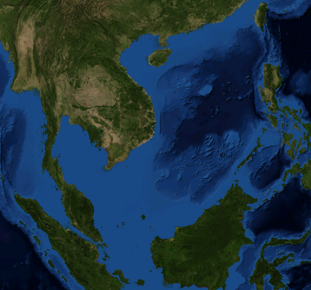
South China Sea
Every nation that touches it calls it something different. To China, it is the South Sea -- Nan Hai -- a name recorded in chronicles dating to the Western Zhou dynasty, three thousand years ago. Vietnam calls it the East Sea, Bien Dong. The Philippines, since 2012, has officially designated its portion the West Philippine Sea. Indonesia renamed its northern exclusive economic zone the North Natuna Sea in 2017. Even the act of naming this body of water is a territorial claim. At 3.5 million square kilometers, the South China Sea stretches from the Strait of Malacca to the Taiwan Strait, bordered by seven countries that agree on almost nothing except that these waters matter enormously.
Where Continents Drowned
The South China Sea sits atop a drowned continental shelf. During the last ice age, sea levels dropped hundreds of meters, and Borneo was part of the Asian mainland. The basin itself began forming roughly 45 million years ago, when a landmass geologists call the "Dangerous Ground" rifted away from southern China. Seafloor spreading began around 30 million years ago, propagating southwest to carve the V-shaped basin that exists today. The process ceased about 17 million years ago, but the debate over what drove it has not. One theory holds that the collision of India with Asia pushed Indochina southeast, shearing open the sea. Others dispute how far Indochina actually moved. What is beyond dispute is what accumulated in the basin afterward: enormous volumes of sediment from the Mekong, Red, and Pearl Rivers, creating deltas rich in oil and gas deposits. The sea's average depth is 1,212 meters; its deepest point plunges to roughly 5,560 meters.
Crossroads of Empires
Long before the territorial disputes, there was trade. The South China Sea has connected northeast Asia, Southeast Asia, India, and the West for centuries. The seafloor is littered with the wrecks of trading vessels -- Swedish engineer Sten Sjostrand alone has excavated nine historic ships carrying ceramics dating from the 10th to the 19th century. The kingdom of Champa, based in what is now central Vietnam, flourished as a maritime power here before the 16th century, lending the waters one of their older names: the Champa Sea. Portuguese sailors in the 1500s called it the China Sea, and the "South" was added later to distinguish it from nearby waters. During World War II, Japan seized control of most of the sea along with the surrounding territories. Today the South China Sea carries $3.4 trillion in maritime shipping annually -- roughly five percent of global GDP. More than half of the world's fishing vessels operate in its waters, harvesting 11.7 million tonnes of fish from the Western Central Pacific in 2010, up from less than 4 million in 1970.
Over Two Hundred Islands Nobody Owns
Scattered across the South China Sea are more than 250 small islands, atolls, cays, shoals, reefs, and sandbars. Most have no indigenous inhabitants. Many disappear beneath the waves at high tide. Some are permanently submerged. And yet they are among the most fiercely contested real estate on Earth. The Spratly Islands sprawl across an area of 810 by 900 kilometers, encompassing around 175 identified features, the largest of which -- Taiping Island -- measures just 1.3 kilometers long with a maximum elevation of 3.8 meters. Reed Bank, a 100-kilometer-wide seamount in the northeast Spratlys, was an island until rising seas submerged it about 7,000 years ago; at 8,866 square kilometers, it remains one of the largest submerged atoll structures in the world. The Paracel Islands, Scarborough Shoal, Pratas Island, and Macclesfield Bank complete the constellation of disputed features. Six governments and Taiwan have staked overlapping claims, fortified outposts on specks of rock, and confronted one another's navies in these waters.
The Nine-Dash Line and the World's Response
Both the People's Republic of China and Taiwan claim nearly the entire South China Sea within the so-called nine-dash line, a boundary that overlaps with the exclusive economic zones of Vietnam, the Philippines, Malaysia, Brunei, and Indonesia. The stakes have drawn blood. In 1974, a brief naval battle between China and South Vietnam over the Paracel Islands killed 18 Chinese and 75 Vietnamese sailors, leaving China in control of the entire chain. In 1988, over 70 Vietnamese sailors died near Chigua Reef in the Spratlys. In 2016, an international tribunal in The Hague ruled that China's nine-dash line had no legal basis under the United Nations Convention on the Law of the Sea -- a ruling China rejected outright. The United States, though not a signatory to UNCLOS, has conducted freedom-of-navigation patrols through the sea, sometimes sailing warships within twelve nautical miles of Chinese-controlled features. In December 2018, a senior Chinese military commentator suggested China's navy should ram American ships. The confrontations have expanded from the surface to the air: in 2025, Australia reported that a Chinese fighter jet dropped flares near one of its patrol planes over the sea, calling the maneuver "unsafe and unprofessional."
From the Air
The South China Sea is centered at approximately 12.00°N, 113.00°E and spans roughly from 3°N to 23°N latitude, bordered by Vietnam to the west, the Philippines to the east, Borneo and Malaysia to the south, and southern China and Taiwan to the north. Major airports on its periphery include Ninoy Aquino International (RPLL) in Manila, Tan Son Nhat (VVTS) in Ho Chi Minh City, Hong Kong International (VHHH), Changi (WSSS) in Singapore, and Kota Kinabalu (WBKK) in Borneo. Overflying aircraft at FL350-FL410 will see open ocean punctuated by the faint outlines of reef systems and, on clear days, the artificial islands China has constructed in the Spratlys. Commercial air routes across the sea are among the world's busiest.