Island-Hopping the Invisible Highway
Before December 7, 1941, Canton Island was a place almost nobody had heard of. A low coral atoll in the Phoenix Islands, three degrees south of the equator, it had no permanent population and no particular strategic value. Within weeks of the attack on Pearl Harbor, it became Station 7 -- a critical link in a chain of airfields stretching from Hawaii to Australia that the United States Army Air Corps built, quite literally, across the emptiest stretches of the Pacific Ocean. The South Pacific air ferry route was born from desperation: Japan had seized the Philippines, cut the shipping lanes, and left the Allies with no reliable way to move aircraft and personnel to the war's southwestern theater. The solution was to fly over what they could no longer sail through.
A Route Conceived Before the War
The idea of ferrying military aircraft across the Pacific predated the conflict by two decades. In the 1920s, the United States Army Air Service had experimented with staging routes to move planes to the Philippines, but the distances were punishing and the infrastructure nonexistent. When General Douglas MacArthur began preparing the Philippine defenses in 1940, he envisioned the Air Corps as the primary deterrent against Japanese aggression, which meant finding a way to reinforce the islands with heavy bombers. The plan called for B-17s to stage through Hawaii, then hop south and west through a series of island airfields before reaching Clark Field or Del Monte Field on Mindanao. It was an ambitious scheme that assumed time the United States did not have. When Japan struck Pearl Harbor and then invaded the Philippines in rapid succession, the ferry route's original purpose -- reinforcing MacArthur -- collapsed. But the route itself would prove more valuable than anyone had imagined.
Stitching the Chain
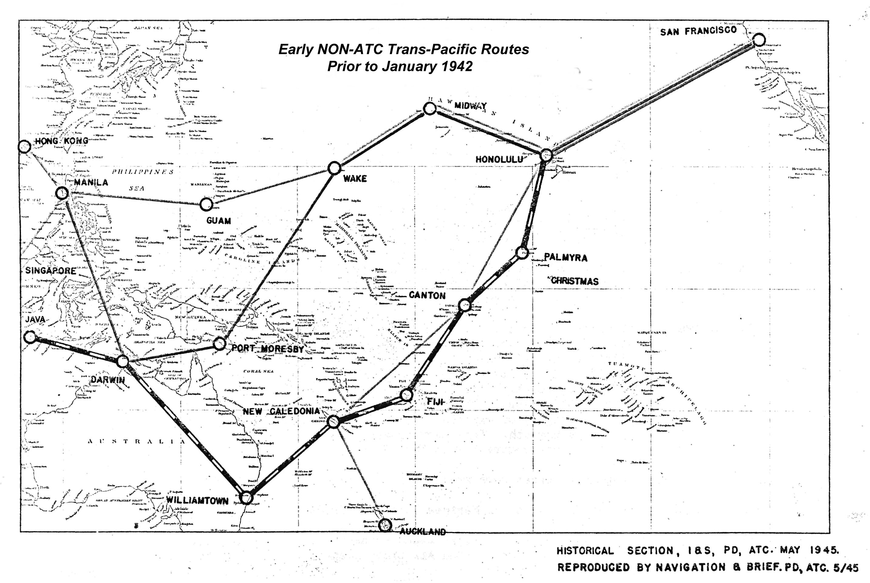
After Pearl Harbor, the only civilian air service still operating across the Pacific was Pan American Airways, and it could not begin to handle military logistics. Normal shipping lanes were severed. The Air Transport Command responded by inaugurating a trans-Pacific cargo and passenger service that skirted the Japanese-controlled waters west of Hawaii, running south through Christmas Island, Canton Island, Fiji, and New Caledonia before reaching Australia. Each stop required a functional airfield, fuel stores, maintenance facilities, and housing for transient crews -- all on islands that in many cases had never seen a construction project larger than a copra shed. Engineers poured coral-and-asphalt runways on atolls barely above sea level. Canton Island's airfield sat 1,046 miles from Christmas Island; Nandi Air Base in Fiji lay another 1,270 miles beyond. Tontouta Airfield in New Caledonia, 787 miles farther on, became the Air Technical Service Command's main supply depot for the South Pacific. From there it was 1,272 miles to RAAF Base Townsville in Queensland. The total distance from Hickam Field in Hawaii to Townsville measured 5,717 miles -- roughly the width of the continental United States, twice over, with nothing but ocean in between.
Staying Ahead of the Enemy
The Japanese did not wait politely while the Americans built their aerial highway. As ground forces pushed through the Southwest Pacific in early 1942, the southern segments of the ferry route came under threat. The 7th Bombardment Group, originally planned to stage B-17s through Darwin and on to Del Monte Field, had to divert to Brisbane when the Philippine situation deteriorated. Del Monte itself, intended as a dispersal field for heavy bombers, never functioned as a ferrying station -- the 19th Bombardment Group's surviving B-17s withdrew through Darwin to Batchelor Airfield in Queensland, where the group reformed. To counter the advancing Japanese, engineers constructed an easterly alternate route farther from enemy advances, running south from Christmas Island Airfield on a path that gave the chain breathing room. It was logistics as warfare: every new airstrip pushed the viable corridor beyond the reach of Japanese air power.
Expansion Across the Pacific
As Allied forces advanced, so did the route. New branches extended to the Solomon Islands and New Guinea in support of combat operations. The Gilbert and Marshall Islands, seized from the Japanese, became way stations. The Marianas opened a more direct path to the western Pacific. By war's end, Air Transport Command routes reached into occupied Japan itself and connected at Kunming Airport in China with the ATC's India-China Wing -- the supply line better known for its Himalayan segment, the Hump. Islands that had been unfamiliar to the outside world before the war, many of them formerly part of the Japanese South Seas Mandate, became bustling air terminals. Plaine Des Gaiacs Airfield in New Caledonia, used occasionally by ATC and the Thirteenth Air Force, was closed in 1945 and left to the vegetation. Today it sits abandoned, overgrown, with small traces of American use still visible in the undergrowth -- a ghost of the logistics machine that once moved an air force across an ocean.
What the Coral Remembers
The South Pacific air ferry route was not a single highway but a branching network that shifted with the war's geography, adding and discarding airfields as the front moved. At its peak, ATC operated Central Pacific, Southwest Pacific, and Southeast Pacific routes simultaneously, a web of scheduled flights connecting points that no airline had ever served. The human cost of building and maintaining this network -- the engineers who poured runways in equatorial heat, the ferry pilots who navigated thousands of miles of open ocean with rudimentary navigation aids, the ground crews who kept fuel flowing on atolls that received everything by ship or air -- rarely makes it into the histories focused on combat. But without these routes, the aircraft that fought at Guadalcanal, New Guinea, and the Philippines could not have gotten there. The invisible highway made the visible war possible.
From the Air
This article describes a Pacific-wide route system, but the Wikipedia entry is geolocated at 38.06N, 122.51W near Hamilton Field in Marin County, California -- a major departure point for Pacific-bound aircraft. Key route waypoints: Hickam Field (PHIK) in Hawaii, Christmas Island (PLCH), Canton Island, Nandi/Nadi (NFFN) in Fiji, Tontouta (NWWW) in New Caledonia, and Townsville (YBTL) in Australia. The route spanned over 5,700 miles. For historical context, Hamilton Field (now Hamilton Air Force Base, decommissioned) sits at the north end of San Francisco Bay near Novato. Best appreciated at cruise altitude while contemplating the vast Pacific distances these ferry pilots covered.