Southern Ute Indian Reservation
In the Ute language, they call it Kapuuta-wa Moghwachi Nuuchi-u. The name carries the identity of the Mouache and Capote bands, two of the three groups that formed the Southern Ute people. Their reservation stretches across southwestern Colorado near the New Mexico state line, a strip of land spanning parts of La Plata, Archuleta, and Montezuma Counties. At over 1,058 square miles, it encompasses forested highlands in the east and arid mesa country in the west. But those numbers only hint at the story. The Southern Utes once ranged across a territory that dwarfed this reservation, from the Rocky Mountain foothills near Denver to the headwaters of the Rio Grande, from the San Luis Valley to the Texas Panhandle.
Bands of the Mountain and Plain
The Capote band, or Kapuuta Nuuchi, made their home east of the Continental Divide, south of the Conejos River and toward the Sangre de Cristo Mountains. They lived in the San Luis Valley and along the Animas River, near present-day Chama and Tierra Amarilla in Rio Arriba County, New Mexico. The Muache, or Moghwachi Nuuchi, ranged farther, along the eastern foothills of the Rockies from Denver south to Las Vegas, New Mexico. They traded with the northern Puebloan peoples, especially Taos Pueblo, earning the nickname Taos-Ute. After adopting the horse, the Muache and their allies, the Llanero band of the Jicarilla Apache, ranged as far southeast as the Texas Panhandle. A third band, the Weeminuche, eventually separated to form what is now the Ute Mountain Ute Tribe on the western end of the original reservation.
Promises Written on Shrinking Maps
The treaty of 1868 granted the Southern Utes roughly one-third of present-day Colorado, mostly the mountainous regions west of the Continental Divide. The promise lasted barely five years. When precious metals were discovered in the central mountains, settlers pushed in, and the Brunot Agreement of 1873 reduced the reservation to the narrow strip it occupies today. Earlier treaties in 1855, 1865, and 1866 had attempted to define Ute territory, but the U.S. Senate failed to ratify any of them. The 1865 treaty had offered the Uintah River valley in Utah plus annual payments of $25,000 for ten years, then $20,000 for twenty years, based on an estimated Ute population of 5,000. President Abraham Lincoln appointed Ouray of the Uncompahgre band as head of all Ute tribes, a decision the Southern Ute bands never accepted.
The Hunter Act and Its Fractures
In 1895, the Hunter Act carved the reservation into individual plots for the heads of Mouache and Capote households, opening vast stretches of land to non-native settlers. The Weeminuche had approved an 1888 congressional bill to relocate them to San Juan County, Utah, but the bill failed. Brought back to Colorado, they refused to return to the old agency grounds and instead established camps on the western end of the reservation. This split cemented the division between the Southern Ute Indian Tribe, centered in Ignacio, and the Ute Mountain Ute Tribe to the west. Today, Ignacio and the nearby community of Arboles remain the largest settlements on the reservation.
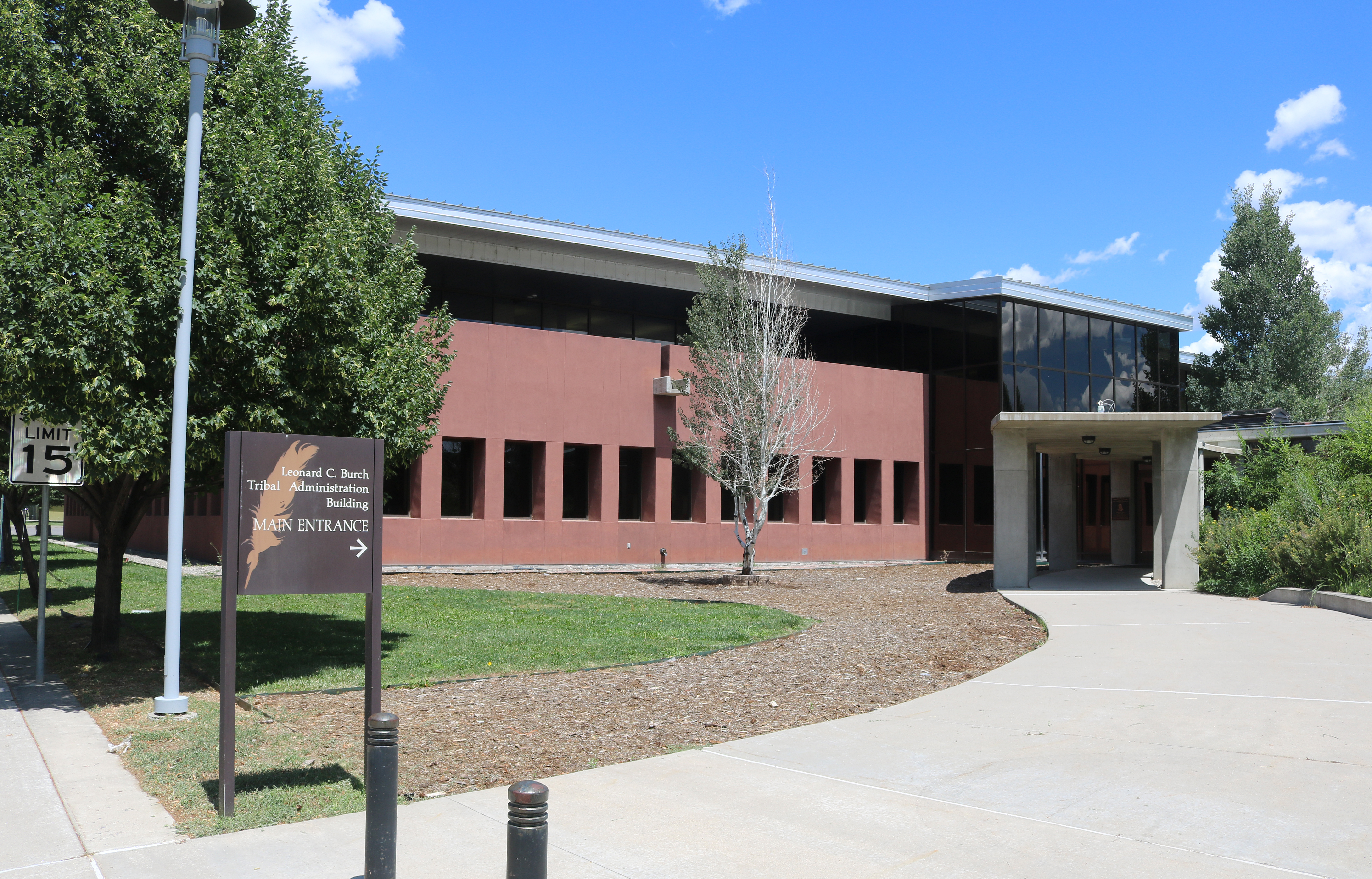
Self-Governance and Modern Enterprise
The Southern Ute Indian Tribe organized its government under the Indian Reorganization Act of 1934, led by a tribal council with an elected chairman. Leonard C. Burch served as chairman for decades through the late twentieth century, providing long continuity of leadership. In 2011, Pearl Casias became the first chairwoman in the tribe's history. The tribe has also turned to environmental innovation: their coalbed methane capture project reduced greenhouse gas emissions by the equivalent of roughly 379,000 metric tons of carbon dioxide between 2009 and 2017. Where conventional methane wells were not economically viable due to low seepage volumes, the tribe found a way to deliver captured gas to pipelines while generating revenue from carbon offset sales.
Land Between Forest and Mesa
From the air, the reservation's geography tells its own story. The eastern portion rises into forested mountains, while the western half drops into arid mesa and open rangeland. The Animas River threads through the landscape, connecting the reservation to a broader network of rivers and valleys that the Ute have known for centuries. Below, the communities of Ignacio and Southern Ute carry on, governed by the same tribal council structure that has adapted through generations. It is a landscape shaped by treaty lines and topography, by forced reduction and stubborn persistence, by a people who once held a third of Colorado and now steward this remaining piece of it with both memory and ambition.
From the Air
The Southern Ute Indian Reservation is centered near 37.11N, 107.65W in southwestern Colorado, stretching across La Plata, Archuleta, and Montezuma Counties. From the air, note the contrast between forested highlands in the east and arid mesa to the west. The town of Ignacio serves as the tribal headquarters. Nearest airports include Durango-La Plata County Airport (KDRO) approximately 20 miles to the north, and Animas Air Park (00C) closer to the reservation. The Animas River provides a strong visual corridor. Best viewed at 3,000-5,000 feet AGL.