Spangen Castle
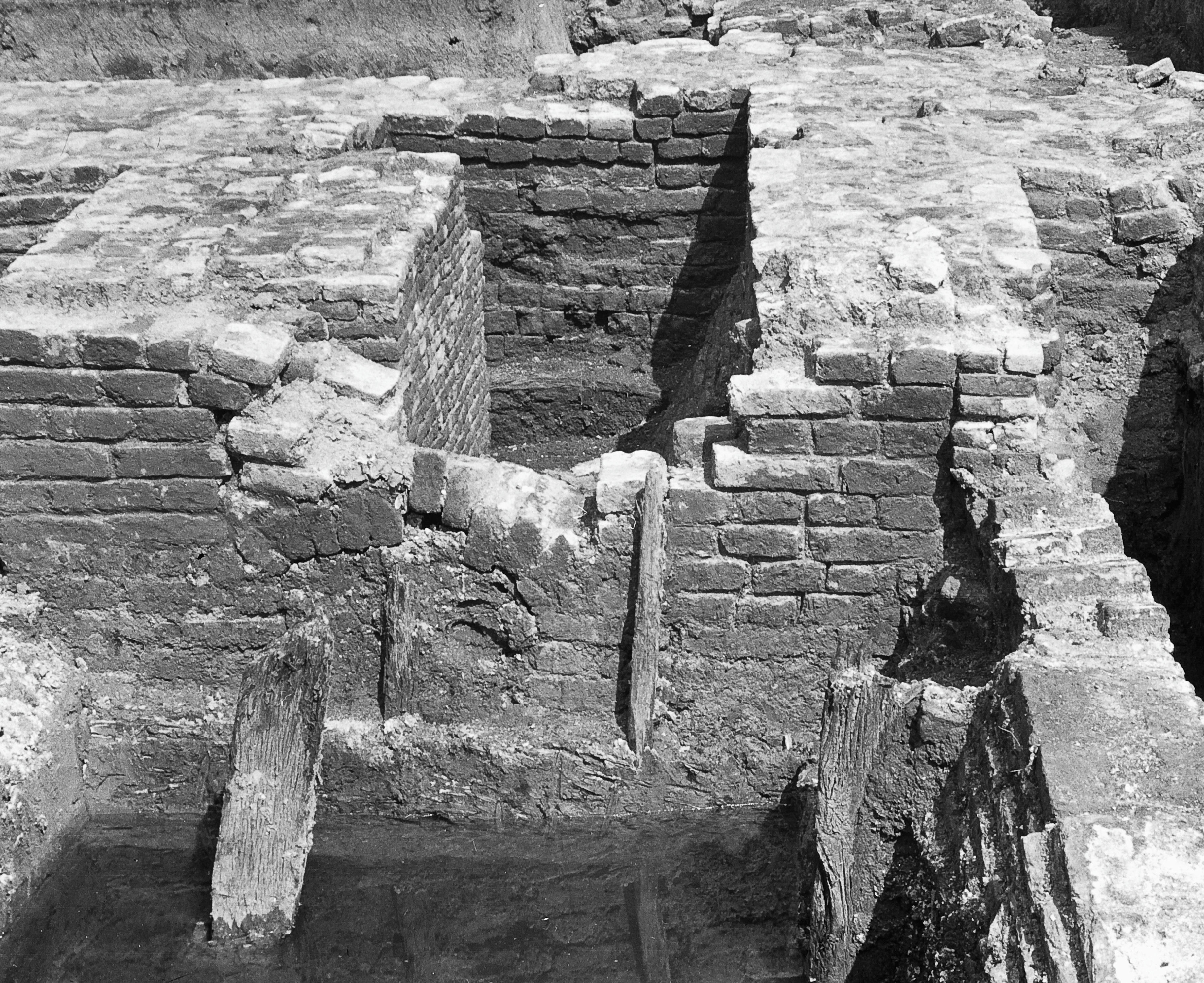
In 1942, in the middle of the German occupation of the Netherlands, Rotterdam's municipal engineers needed to dig a new inland harbor in a quiet corner of the Spangen district. The site was nothing special - empty grass, a former canal embankment, the kind of land a busy port city periodically reorganizes. But the city historian Johan Ringers had a theory: somewhere under this grass, he believed, lay the foundations of a medieval castle that had stood here for two and a half centuries and then vanished so completely that locals in 1900 could no longer point to where it had been. Ringers persuaded the occupation authorities to allow an archaeological survey before the bulldozers arrived. The archaeologist Jaap Renaud spent that wartime summer carefully troweling away topsoil. Six meters down, he found a tower house. Above it, on the surface of his floor plan, he had drawn the outline of a castle that had not been seen by any living eye in eighty years.
The Family Who Took the Name
The castle's first owner was a minor knight named Philips Uytter Nesse, mentioned in surviving documents in 1307. His name simply meant Philip Out of the Headland - Nesse being the local word for a promontory of land jutting into water. In 1323 his probable descendant Dirk Bokel was granted 47 morgen of farmland along a small river called the Spange. He kept twenty-seven morgen, built a stone tower on it, and his son Jan rebranded the family as Jan van der Spange. Within a generation the family identity had been transferred from the original headland to a small new estate. The pattern is common in medieval Holland: the land made the lord, the lord renamed himself for the land, and the new name eventually replaced the old. Rotterdam's modern Spangen district takes its name through this exact chain - from a vanished castle through a vanished family from a vanished river.
Four Phases in Brick
Renaud's careful 1942 excavation could date the castle's growth by the bricks themselves. The oldest part, the early fourteenth-century tower house, was built of dark red brick measuring 31 by 15 by 7 centimeters - massive by later standards, with walls more than two meters thick on the moat sides and much thinner on the courtyard side. The owners had not yet decided to defend all four walls equally. Later in the century a second phase added a brick perimeter wall around a small courtyard, in pale red brick 26 by 13 by 6 centimeters - noticeably smaller and lighter. In the fifteenth century the family filled in part of the moat itself and built a new northeast wing with a rare medieval cavity wall, using a harder pale-red brick of 22 by 10 by 5 centimeters. The final phase, around 1500, added annexes in a distinctive yellow IJsselsteen brick. The whole excavated floor plan reads like a family fortune slowly improving: each generation, smaller bricks and bigger ambitions.
Hook and Cod
From 1350 to roughly 1490, the County of Holland tore itself apart in a civil war so peculiar that historians named it for fish. The Hooks - Hoeken - and the Cods - Kabeljauwen - were the two factions in a dynastic dispute over the succession to William IV. The factions outlived the original quarrel by more than a century, becoming inherited identities that ordinary Dutch farmers, burghers and knights kept for generations. Dirk van Spangen, the castle's lord in the mid-fourteenth century, was on the Hook list. Whether his castle was burned by Cod forces in 1351, as one contemporary chronicler claimed, or simply surrendered, has never been settled. What is certain is that the family kept switching sides over the next 150 years, and the castle kept being expanded, garrisoned and quietly damaged.
The Geuzen Take It, the Royalists Burn It
The end came during the opening phase of the Eighty Years' War - the Dutch Revolt against Spanish Habsburg rule. In 1572 the Sea Beggars - Watergeuzen - the irregular Protestant militia commanded by William de la Marck, the Count of Lumey, occupied Spangen Castle as a base for raids against the Spanish garrisons in the area. The Spanish reaction was swift: a force from Delft retook the castle, sacked it, and in 1574 the Royalist Army burned what was left to prevent any further occupation by either side. The Van der Spangen family had already moved south to the Southern Netherlands - what would become Belgium - and never returned. The ruins stood for two more centuries, a useful subject for landscape engravers but increasingly mined for building stone. The last visible walls disappeared sometime in the second half of the nineteenth century. By 1900 even the location was uncertain.
The Spangen That Replaced It
The modern Spangen district of Rotterdam, built in the early twentieth century on the site of the long-buried castle and its surrounding farmland, is now best known for something the medieval Van der Spangens would have found incomprehensible: it is the home of Sparta Rotterdam, the city's oldest football club, founded 1888. Het Kasteel - The Castle - is the affectionate name fans use for Sparta's stadium, whose mock-medieval brick facade and crenelated towers nod to the vanished real castle that once stood a few hundred meters away. The naming is too perfect to be accidental, and turns out not to be: when Sparta opened the stadium in 1916, the architects chose the design specifically as a tribute to the lost Spangen Castle. The real castle is a floor plan in a 1942 archaeological monograph. The fake castle hosts league matches every weekend. Both are remembered. Different cities choose different forms of memory.
From the Air
Spangen Castle's original site sits at 51.93 N, 4.43 E, in the modern Spangen district of west Rotterdam, between the Delfshavense Schie canal and the railway line west out of Rotterdam Centraal. Nothing of the castle is visible from above. The Sparta Rotterdam stadium - Het Kasteel - about 400 m southwest is the easiest visual landmark, distinguished by its mock-medieval brick towers. The site is roughly 2.5 km west of the Erasmusbrug and the Rotterdam city centre. Rotterdam The Hague Airport (EHRD) is about 5 km north. Industrial buildings of the Marconiplein area dominate the surrounding skyline.