Spokane: The Lilac City Where the Inland Northwest Meets
Spokane is the center of something called the Inland Northwest - a region that's not quite Pacific Northwest (too dry, too conservative) and not quite Northern Rockies (too wet, too urban). The city of 230,000 (metro area of 580,000) occupies the point where water meets desert, the Spokane River providing the falls that powered early industry, the surrounding landscape transitioning from forested mountains to wheat-covered plateau. Spokane was a railroad hub, then a mining supply center, then a city in slow decline, then the host of Expo '74 (the environmental World's Fair that cleaned up the riverfront), and now something new: an affordable alternative for those priced out of Seattle, a destination for outdoor recreation, a city finally becoming what its setting suggests it should be.
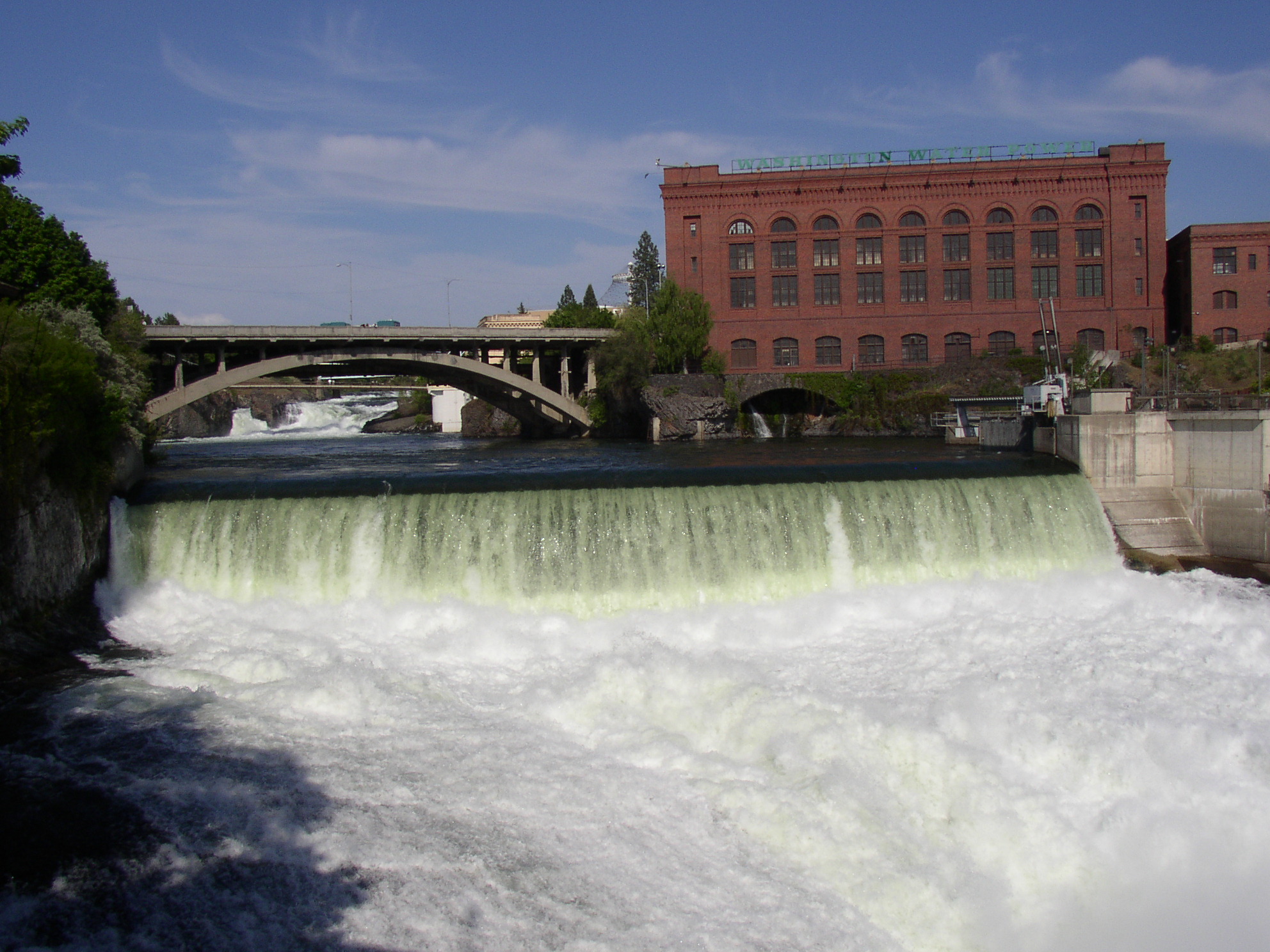
The Falls
The Spokane Falls, in the heart of downtown, drew the first settlers and powered the first mills. The falls are impressive - 100 feet of drop in a series of cascades, visible from bridges and parks, the reason the city is here. For decades, railroad tracks and industrial buildings blocked the falls from view; Expo '74 cleaned up the riverfront, removed the tracks, and created Riverfront Park. The falls are now Spokane's symbol, visible from downtown, crossed by the SkyRide gondola that Expo left behind. The city that hid its best feature for a century now celebrates it.
The Expo
Expo '74 was the smallest world's fair in modern American history - and possibly the most successful. The theme was environmental, the result was a cleaned-up riverfront that transformed downtown Spokane. The railroad tracks that blocked the falls were removed; the industrial pollution was addressed; Riverfront Park emerged from industrial wasteland. The fair drew 5 million visitors to a city of 170,000. The legacy persists: the park remains, the gondola still runs, the commitment to livable downtown that Expo demonstrated continues to shape city planning. Expo '74 showed that small cities could achieve large transformations.
The Politics
Spokane is the most conservative city in Washington, the red to Seattle's blue. The political divide reflects cultural differences: Spokane is more religious, more rural-connected, more suspicious of government, more attached to guns and trucks and traditional values. The refugees from Seattle's prices bring some political diversity, but Spokane remains culturally distinct from the coast. The tension between liberal Seattle and conservative Spokane shapes state politics; the I-90 corridor is the dividing line between two Washingtons that share a state but not much culture. Spokane is Washington for those who find Seattle too expensive and too progressive.
The Outdoors
Spokane's outdoor access is the appeal - skiing at 49 Degrees North and Mount Spokane, hiking in the surrounding mountains, lakes within driving distance, the sense that wilderness is close. The Centennial Trail runs 37 miles from downtown to the Idaho border. The climate is four-season: cold winters with real snow, hot dry summers, the distinct seasons that coastal Washington lacks. The outdoor orientation explains why people tolerate the winter cold and the summer smoke from forest fires. Spokane is a base camp for a region of natural beauty.
Visiting Spokane
Spokane is served by Spokane International Airport (GEG). Riverfront Park and the falls are essential; the SkyRide gondola offers views. The Northwest Museum of Arts and Culture covers regional history and indigenous culture. Manito Park provides gardens and greenhouse. The Kendall Yards neighborhood offers restaurants and urban atmosphere. For day trips, Coeur d'Alene (30 miles east) provides lake access; Grand Coulee Dam (90 miles west) shows massive engineering. The food scene is improving; the craft beer scene is established. Summer is best; winter is cold but skiable; smoke from forest fires can affect air quality in August.
From the Air
Located at 47.66°N, 117.43°W where the Spokane River's falls provided power at the transition between mountains and plateau. From altitude, Spokane appears as urban development at the landscape transition - forested hills to the north and east, wheat-covered plateau to the south and west. The Spokane River cuts through the city. What appears from altitude as eastern Washington's largest city is the Lilac City - where the falls power and attract, where Expo '74 transformed the riverfront, and where the affordable Northwest draws those priced out of Seattle.