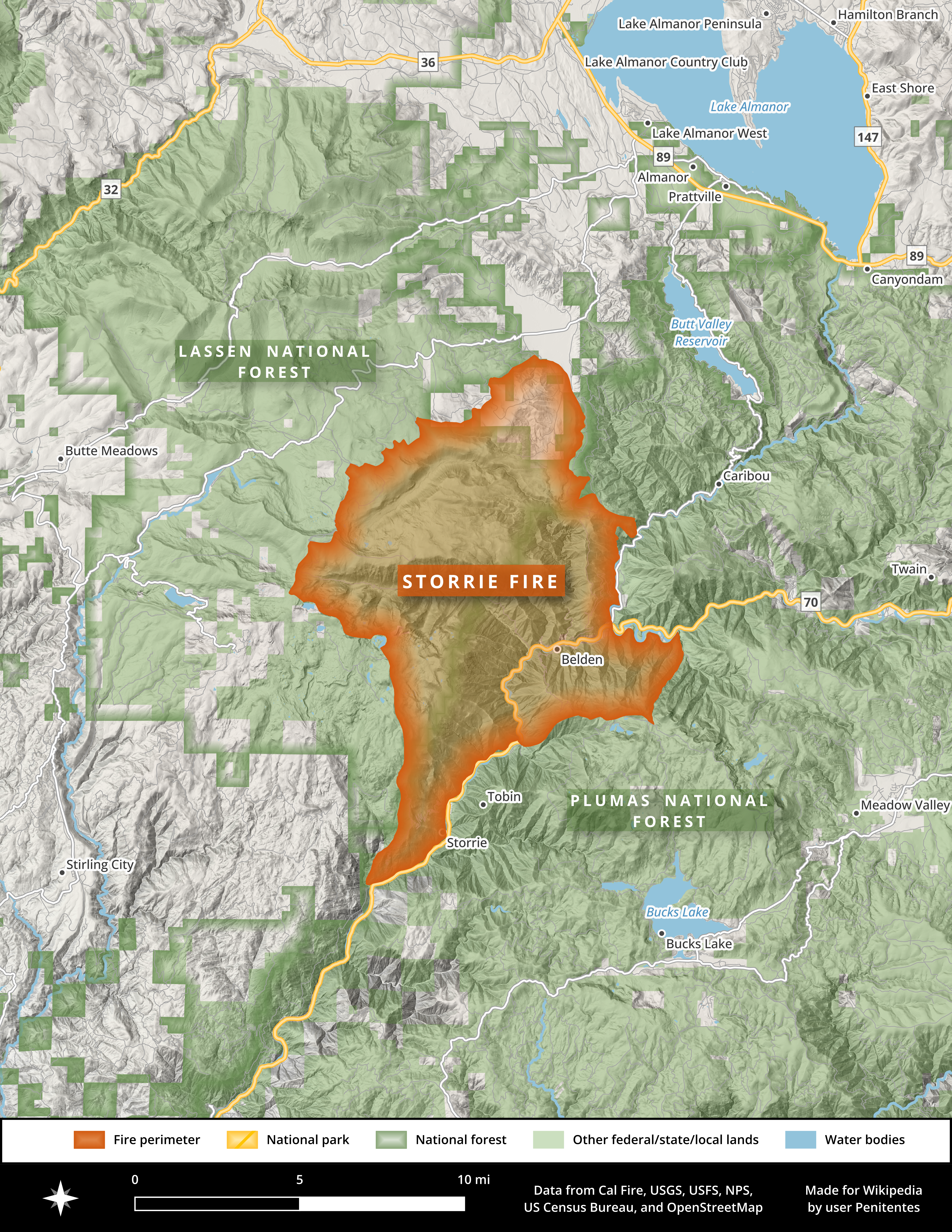
Storrie Fire
The five-person Union Pacific crew was doing routine work on the Feather River Route that August afternoon in 2000. Using a saw to cut through rail, then a grinder to smooth the edge, they worked in the steep terrain near the tiny community of Storrie. Later tests would show their sawing process could throw fragments of hot metal nearly 40 feet. The workers had not employed spark shields. They had not cleared flammable material from the area. In the drought-parched canyon, where temperatures had stayed hot and dry for weeks, a single spark was all it took. Within hours, fire was racing up the rugged slopes of the Feather River Canyon.
Canyon of Fire
The Feather River Canyon is a funnel for flame. The gorge runs much of the width of the Sierra Nevada range, winding northeast from Lake Oroville toward Indian Valley and Lake Almanor. In places, canyon walls rise more than 5,000 feet from the river to surrounding peaks. Before the Storrie Fire, large blazes had already swept through in 1999. After it, the canyon would burn again in 2008, 2012, 2018, and 2021. The Dixie Fire of 2021 would eventually reburn nearly all of the Storrie Fire's footprint. But in 2000, only 12 percent of the area had burned in the previous century. The landscape was primed with decades of accumulated fuel. When fire was first spotted on a steep slope that afternoon, it measured just a quarter acre. By 5:20 PM, officials closed Highway 70. By 8:00 PM, the fire had consumed 800 acres.
Spotting Ahead
On August 19, winds drove the fire with terrifying speed. The burned area more than doubled to 5,000 acres as embers launched ahead of the main fire front, landing more than a mile away in the Indian Creek drainage. Flames jumped across the Feather River Canyon and Highway 70 for the first time near Rodgers Flat, igniting the Bucks Lake Wilderness. Voluntary evacuations began for canyon communities: Belden, Seneca, Caribou Road, Butt Lake. The following night, the fire damaged electrical infrastructure, cutting power to more than 20,000 people from Quincy and Lake Almanor to Susanville. By August 21, over 1,100 firefighters and aircraft were battling the blaze as it continued burning north toward Lake Almanor, growing past 22,000 acres with just 20 percent containment.
Labor Day Relief
By early September, the Storrie Fire had burned more than 50,000 acres, with over 18,000 of those in the Bucks Lake Wilderness. Flames had approached within three miles of Chester. Then the weather shifted. Over Labor Day weekend, nearly an inch of rain fell on the fire area, aiding exhausted crews who had been fighting flames for three weeks. The Forest Service declared decreased potential for significant fire spread. On September 9, crews achieved full containment. The fire was declared controlled on September 27, having burned 56,000 acres total. No deaths occurred, though three firefighters were injured by falling rocks and two developed heat exhaustion. Property damage was limited to a single shed in the Rich Bar area. The cost of suppression reached $22 million.
What Is a Forest Worth?
In 2006, the U.S. government sued Union Pacific for $200 million. The railroad's crew members gave conflicting sworn testimony about how they had responded when they first noticed fire: two said they put water on it, two said they did not; two said they stomped on it, three said they had not. In February 2008, U.S. District Judge Frank Damrell Jr. issued a ruling that changed wildfire litigation forever. He allowed the government to seek damages beyond just timber destruction and suppression costs. For the first time, federal prosecutors could claim compensation for habitat and wildlife damage, loss of recreational usage, and what the judge termed the area's grandeur. They could also seek reforestation costs. Legal experts called it a landmark decision that expanded how America values public lands harmed by fire.
The $102 Million Lesson
Union Pacific settled for $102 million, which the company paid from insurance proceeds. The settlement acknowledged that a wildfire's true cost extends far beyond the timber that burns. The Storrie Fire's aftermath also revealed tensions over forest management. Environmental groups appealed multiple proposed salvage logging operations in the burned area, successfully blocking plans in both Plumas and Lassen National Forests. The Sierra Club and others argued that officials were attempting to pass healthy trees as doomed. By the time logging projects finally won approval in August 2002, two years after the fire, the dead trees had begun to rot and logging companies lost interest. The Feather River Canyon would burn again and again in the years that followed, each new fire rewriting the landscape. Nearly all of the Storrie Fire's footprint eventually reburned in the 2021 Dixie Fire, the canyon's pattern of destruction continuing where railroad sparks had once started it all.
From the Air
The Storrie Fire burn area is centered around 39.92N, 121.32W in the Feather River Canyon of Plumas County. The community of Storrie sits along Highway 70 and the Union Pacific's Feather River Route, visible threading through the canyon below. Lake Oroville lies to the southwest, Lake Almanor to the northeast. The Bucks Lake Wilderness extends south of the canyon. Nearby airports include Quincy-Gansner Field (2O1, 15 miles east), Oroville Municipal (KOVE, 30 miles southwest), and Chico Municipal (KCIC, 50 miles west). The area is best appreciated from 4,000-6,000 feet AGL, where the dramatic relief of the canyon becomes apparent. Much of this area has since reburned in subsequent fires, including the 2021 Dixie Fire.