Storseisundet Bridge
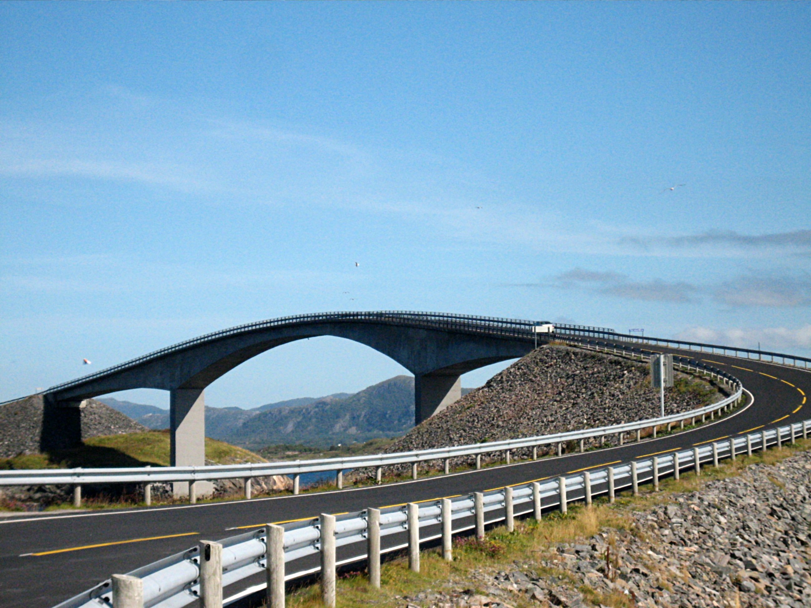
From certain angles, Storseisundet Bridge appears to lead nowhere. The road rises, curves sharply upward, and seems to end in midair -- a trick of perspective that has made it one of the most photographed bridges in the world and earned it the informal nickname "the road to nowhere." The illusion dissolves as you drive onto it, but the drama does not. At 260 meters, Storseisundet Bridge is the longest and most recognizable of the eight bridges that compose Norway's Atlantic Ocean Road, the 8.3-kilometer stretch of County Road 64 that hops between skerries and islands along the exposed coast of More og Romsdal.
Engineering Against the Elements
Storseisundet Bridge is a cantilever design, rising to a maximum clearance of 23 meters above the sea. Including the earthen embankments on both ends, its total length reaches approximately 750 meters. Construction took six years, during which workers on the exposed archipelago were battered by twelve major windstorms. The Norwegian Sea offers little shelter here -- Hustadvika, the stretch of water the bridge overlooks, is one of the most notoriously rough sections of Norway's coast. The bridge opened on July 7, 1989, along with the rest of the Atlantic Ocean Road, and operated as a toll crossing until June 1999. Planners had projected fifteen years of toll collection to recoup the investment, but the road's popularity meant the debt was cleared in just ten years.
The Bridge Between Two Municipalities
The municipal boundary between Hustadvika Municipality and Averoy Municipality runs directly beneath Storseisundet Bridge, making it a literal border crossing as well as an engineering achievement. The bridge sits at the heart of the Atlantic Road's route, connecting the mainland side to the island of Averoya and its communities. Before the road opened, the Tovik-Orjavik ferry was the only way across. The bridge replaced dependence on timetables and weather cancellations with a fixed link that functions year-round, though winter storms can still make the crossing a white-knuckle experience. Waves breaking over the road surface during gales have become a spectacle in their own right, drawing photographers and thrill-seekers who time their visits to coincide with rough weather.
A Road to Somewhere After All
Storseisundet Bridge has become arguably the defining image of the Atlantic Ocean Road, which the Norwegian construction industry named the "Norwegian Construction of the Century" in 2005. The Guardian declared the overall route the world's best road trip in 2006, and the bridge's distinctive curving profile appears in most photographs and promotional materials associated with the designation. More than ten automotive manufacturers have filmed television commercials along the road, many choosing Storseisundet Bridge as the backdrop. The bridge's visual drama -- the way it seems to launch vehicles into empty sky before revealing the road's continuation on the far side -- has made it a symbol of Norwegian coastal engineering. The Norwegian Directorate for Cultural Heritage preserved the entire Atlantic Ocean Road as a cultural heritage site in December 2009, a designation that protects the bridge along with the rest of the route as one of Norway's eighteen National Tourist Routes.
From the Air
Storseisundet Bridge is at 63.02N, 7.35E on the Atlantic Ocean Road along the More og Romsdal coast. The bridge's distinctive curved cantilever profile is visible from the air -- it arcs dramatically between two low skerries. Nearest airports are Kristiansund Airport Kvernberget (ENKB) about 30 km north and Molde Airport Aro (ENML) about 50 km east. Best viewed at 2,000-4,000 ft AGL for the bridge's distinctive silhouette against the sea.