Straits State Park
Two promises were made and never kept at Straits State Park. Twice, planners agreed to build a pedestrian bridge to reconnect sections of the park that highway construction had severed. Neither bridge was ever built. It is a small irony for a place whose identity is now defined by a bridge -- the Mackinac Bridge, whose five-mile span dominates the view from nearly every campsite and overlook in the park. Established in 1924 on the northern shore of the Straits of Mackinac in Michigan's Upper Peninsula, Straits State Park has spent a century being carved up, reimagined, and rebuilt, and through it all has remained one of the finest places to watch the sun set behind one of America's most iconic engineering achievements.
Where Two Peninsulas Almost Touch
The Straits of Mackinac are the narrow passage where Lake Michigan flows into Lake Huron, a bottleneck of open water separating Michigan's Upper and Lower Peninsulas. For centuries, this crossing defined travel in the region. The Anishinaabe peoples paddled canoes through the straits long before European explorers arrived. Father Jacques Marquette established a Jesuit mission near present-day St. Ignace in 1671, and the area became a critical waypoint for the fur trade. Straits State Park sits on the northern bluffs above this crossing, in Moran Township and the town of St. Ignace in Mackinac County. Within its boundaries lies the Father Marquette National Memorial, a tribute to the French Jesuit explorer who made this shore his final home. From the park's elevated vantage points, the full sweep of the straits is visible, a corridor of deep blue water framed by the forested shores of two peninsulas.
A Park Remade by the Bridge
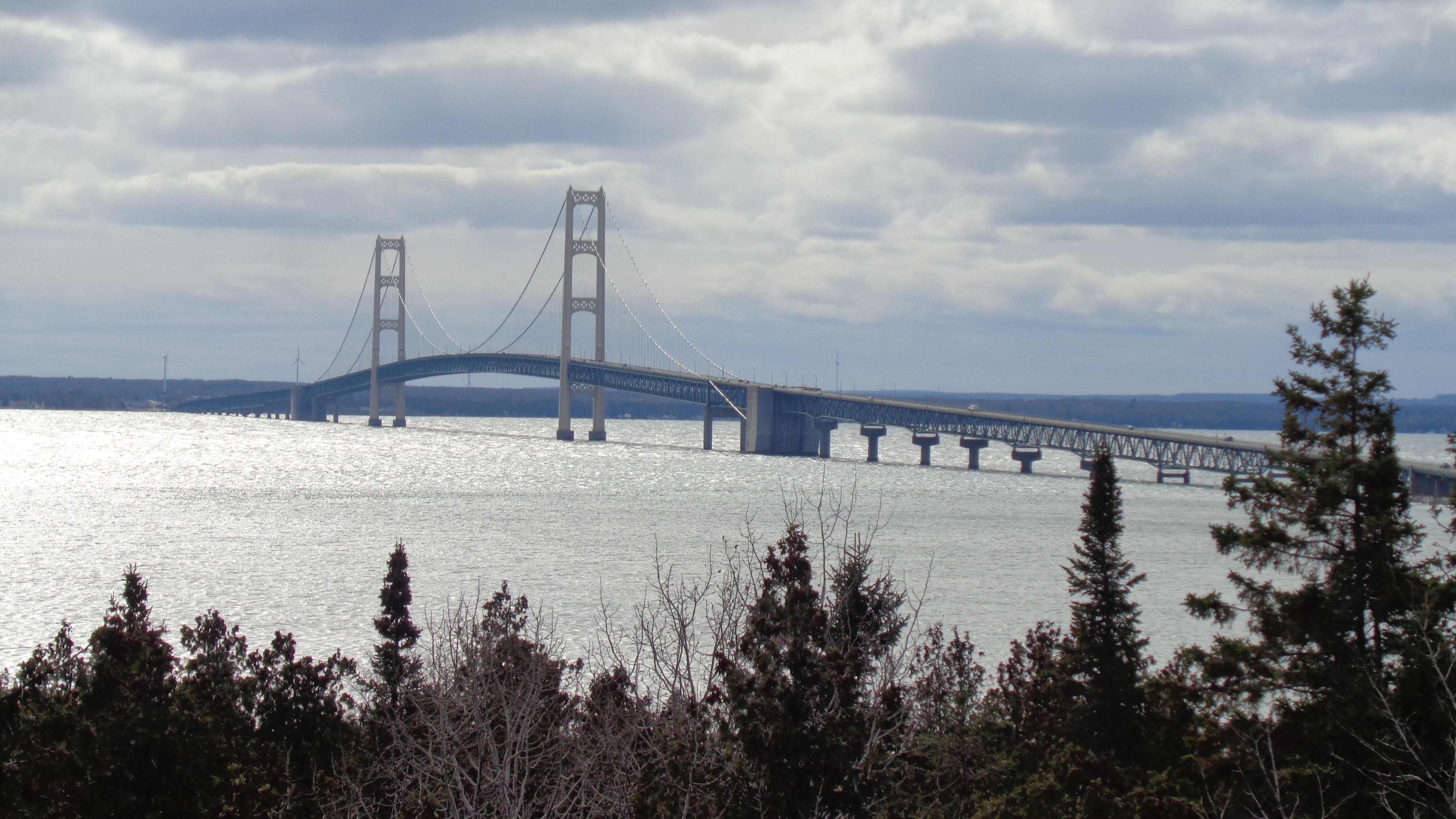
When Straits State Park opened in 1924, it was a simple day-use park at the corner of Paro and Hombach streets. By the mid-1940s, 32 tent campsites lined the shore, drawing families who arrived in St. Ignace aboard car ferries from the Lower Peninsula. The ferry dock sat just half a mile from the park entrance. Then the Mackinac Bridge changed everything. Construction began in the mid-1950s, and the approach road was designed to slice directly through the park's recently expanded northern section. A compromise promised a pedestrian bridge to reconnect the severed halves, but it was never built. Plans for a Mackinac Bridge Museum on the northern end would have taken still more parkland; the museum was never constructed either. That land eventually became the Upper Peninsula Welcome Center. The park adapted, as parks do, and today its 255 campsites are spread across lower and upper sections, with the bridge itself as the main attraction rather than the obstacle.
Marquette's Last Shore
In 1975, the decision was made to create the Father Marquette National Memorial on the park's western section, across Interstate 75. Once again, a pedestrian bridge was proposed to link the memorial to the rest of the park. Once again, it was never built. The memorial and its museum opened in 1979, offering interpretive trails that traced the life of the Jesuit missionary who explored the Mississippi River and founded missions across the Great Lakes. Then, in 2000, lightning struck the museum building and burned it to the ground. The memorial grounds remain, but the museum's destruction underscored the fragility of even our efforts to preserve memory. Father Marquette himself died in 1675 near present-day Ludington, Michigan, but his legacy is deeply rooted in the straits. The memorial's trails wind through the woods above the water, offering quiet contemplation far from the bustle of the campground.
Campfire Views of Big Mac
The modern park, renovated extensively in the 1970s and again in 2003 and 2004, is organized around its relationship with the Mackinac Bridge. The bridge overlook, an accessible structure with coin-operated binocular scopes, provides a side-on view of the suspension span that locals call 'Big Mac.' A hiking trail running through the park leads to the spot where surveyors laid out the bridge's construction lines, believed to be directly beneath the bridge's center point. The trail connects to the North Country Trail, the 4,600-mile footpath that stretches from North Dakota to Vermont, marked here with blue blazes against the park trail's yellow. Three playground areas, picnic groves with charcoal grills, and two rentable mini cabins round out the amenities. Swimming is technically allowed but rarely attempted, given the rocky Lake Huron shoreline and the cold currents pouring through the straits.
The View from Above
From the air, Straits State Park reads as a green wedge along the northern shore, bisected by the pale ribbon of Interstate 75 as it feeds into the Mackinac Bridge approach. The bridge itself stretches southwest across the straits, its twin towers rising from the deep blue water like needles. St. Ignace spreads along the shore to the east, and Mackinac Island is visible a few miles to the southeast, its white limestone bluffs catching the light. The park's observation tower, accessible from the North Country Trail spur, offers a taste of this aerial perspective at ground level. For a century, this park has existed in the shadow of something grander, first the straits themselves, then the bridge that spans them, yet it has quietly maintained its own particular appeal: the simple pleasure of watching the bridge lights trace a glowing arc across the water after dark, from the warmth of a campfire on the shore.
From the Air
Coordinates: 45.853N, 84.719W. Straits State Park lies on the northern shore of the Straits of Mackinac, immediately east of the Mackinac Bridge approach on the Upper Peninsula side. The park is clearly visible as a forested area along the shore west of St. Ignace. The Mackinac Bridge, one of the longest suspension bridges in the Western Hemisphere, dominates the view. Nearby airports: Pellston Regional (KPLN) approximately 20 miles south, and Mackinac Island Airport (KMCD) about 8 miles southeast. Recommended viewing altitude: 3,000-6,000 feet AGL. Best viewed on clear days when the bridge and both peninsulas are visible.