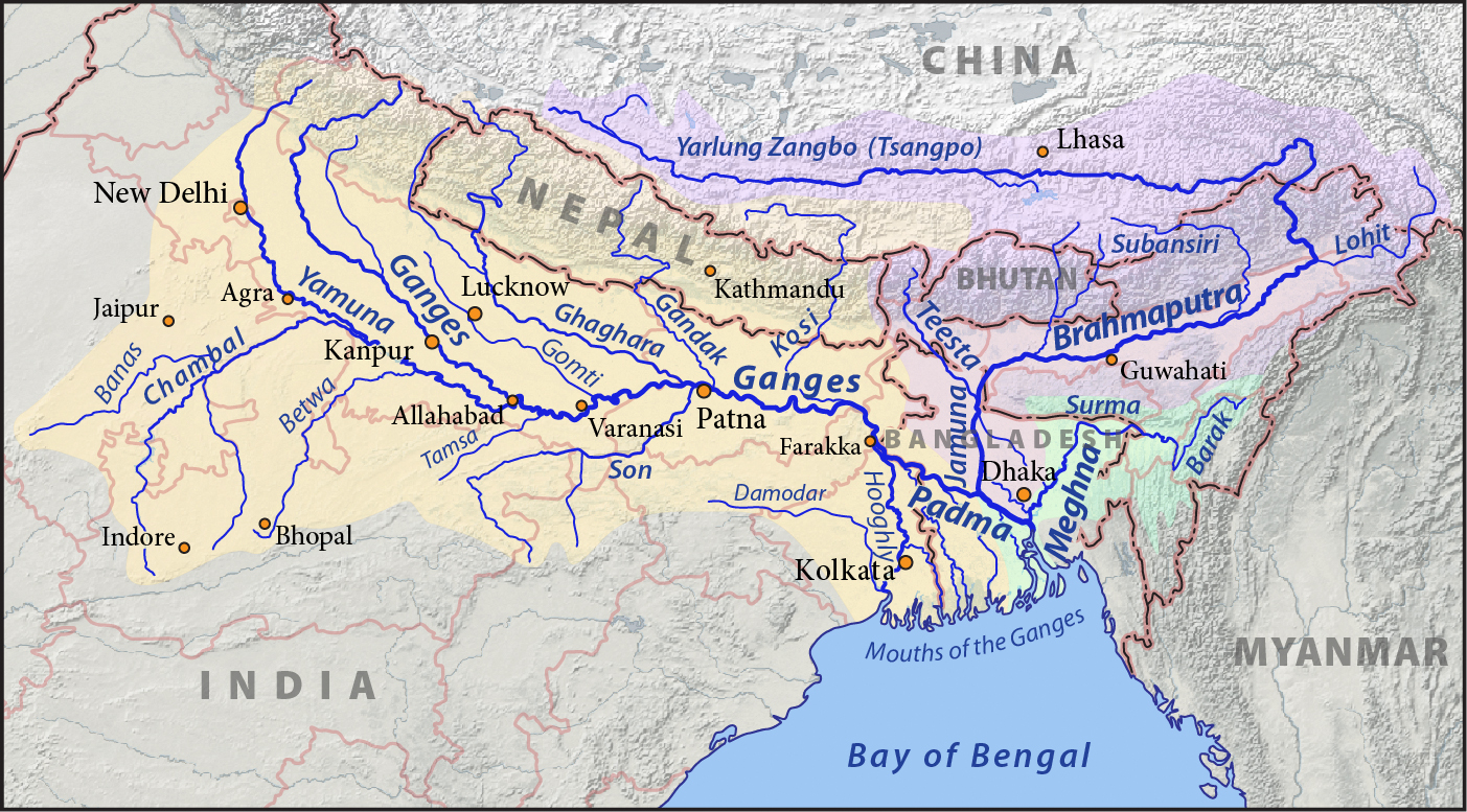
Subansiri River
Its name means gold, from the Sanskrit svarna, and the Mising people who fish its lower reaches call it Obonori, a word rooted in a relationship with this river that predates any written record. The Subansiri begins not as one stream but as several, gathering its waters from Tibetan valleys where Buddhist pilgrims once walked a twelve-year circumambulation circuit around a sacred peak. By the time it joins the Brahmaputra at Jamurighat in Assam's Lakhimpur district, it has traveled 518 kilometers, drained a basin of 32,640 square kilometers, and contributed nearly 8% of the Brahmaputra's total flow, making it that great river's single largest tributary.
Two Rivers Become One
The Subansiri's story begins as two distinct rivers converging at Chayul Dzong in Tibet. The Nye Chu originates in Tsome County and flows roughly 100 kilometers through the Nyelto valley, passing the towns of Ritang and Kyitang before reaching the confluence. The Loro Chu forms from the merger of its own two headwaters: the Loro Karpo Chu (the "White Loro River") and the Loro Nakpo Chu (the "Black Loro River"), both rising in Tsona County. Together they create the Chayul Chu, which flows about 50 kilometers through Tibet, gathering the Char Chu and Yume Chu tributaries before crossing into Arunachal Pradesh near the town of Taksing. Only then does it take the name Subansiri, flowing east and southeast through the Miri Hills before turning south toward the Brahmaputra. The river lends its name to two entire districts in Arunachal Pradesh: Upper Subansiri and Lower Subansiri.
The Sacred Circuit of Dakpa Sheri
The Tsari Chu, one of the Subansiri's major tributaries, flows through terrain that Tibetan Buddhists consider holy ground. At the center of the Tsari district rises Dakpa Sheri, a mountain peak held to be the home of the tantric deity Demchok (Chakrasamvara) and his consort Dorje Phagmo (Vajravarahi). No animals were killed and no food was grown in the sacred areas around the peak, with the sole exception of the town of Migyitun. Every twelve years, during the monkey year of the Tibetan calendar, pilgrims performed the rongkor, or "ravine circuit," a wide circumambulation that followed the Tsari Chu valley to its junction with the Subansiri, then returned via the Subansiri and Yume Chu valleys. The last rongkor took place in 1956. The Sino-Indian border dispute sealed the route, and the pilgrimage has not been completed since.
When the Earth Moved
On August 15, 1950, one of the most powerful earthquakes in recorded history struck the region where Tibet meets Assam. The 1950 Assam-Tibet earthquake, measuring 8.6 on the Richter scale, triggered massive landslides that blocked the Subansiri's flow at Gerukamukh. For three days, the river backed up behind the natural dam. When it broke, the resulting flash flood swept downstream with devastating force, reshaping the riverbed and the communities along it. The Subansiri's discharge range tells the story of a river capable of extremes: it swings from a minimum flow of 131 cubic meters per second to a maximum of 18,799, a variation factor of more than 140. Flooding remains an annual threat to the people living along its lower reaches, where the river spreads across the Assam Valley before joining the Brahmaputra at Jamurighat.
A Dam and Its Discontents
The Lower Subansiri Hydroelectric Project, an under-construction gravity dam at Gerukamukh, has become one of northeast India's most contentious infrastructure projects. Proponents point to the region's vast untapped hydroelectric potential. Opponents, including local communities and environmental organizations, warn of the dam's social and environmental consequences in an earthquake-prone zone that already demonstrated its capacity for catastrophic natural damming in 1950. The controversy has inspired protest movements and even a novel, Ishan Kashyap Hazarika's The River, which tells the story through the imagined perspectives of dolphins, fish, and human characters along the Subansiri. The debate crystallizes a tension that runs through all of northeast India: the gap between the region's resource wealth and the aspirations of the people who live closest to it.
From the Air
Located at approximately 26.89°N, 93.91°E where the Subansiri meets the Brahmaputra in the Assam Valley of northeast India. The river is a major visual feature from the air, flowing generally north-to-south from the Himalayan foothills to the Brahmaputra floodplain. Nearest airports include Lilabari (VELR) and Dibrugarh (VEMN). The river valley is flanked by mountains to the north and the broad Brahmaputra floodplain to the south. Heavy monsoon conditions (May-September) bring flooding and reduced visibility. The construction site at Gerukamukh is visible from moderate altitude as a cleared area in the forested gorge.