Suez Canal
Ferdinand de Lesseps was a diplomat, not an engineer, and that may explain why he succeeded where engineers had hesitated. In 1854, leveraging a personal friendship with Egypt's ruler Sa'id Pasha, the Frenchman secured the concession to build what experts, bankers, and the British Empire all considered impossible or unwise: an artificial waterway, with no locks, cut at sea level through 193 kilometers of desert to connect the Mediterranean and Red seas. Construction began on 25 April 1859 and lasted a decade. When the Suez Canal opened on 17 November 1869, with fireworks over Port Said and the Empress Eugenie aboard the imperial yacht, it changed the geometry of world trade overnight. Combined with the American transcontinental railroad, completed six months earlier, the canal made it possible to circle the globe in record time. It has been fought over, nationalized, blockaded, and bombed -- and it still carries roughly 50 ships and 12 percent of the world's trade every day.
The Dream That Would Not Die
The desire to link the Mediterranean to the Red Sea is nearly four thousand years old. Pharaoh Senusret III may have started digging an east-west canal from the Nile through the Wadi Tumilat around 1850 BC. The Persian king Darius I took up the work around 500 BC. Ptolemy II reportedly completed it with the world's first canal lock around 274 BC. Roman Emperor Trajan rebuilt it, the Arab commander Amr ibn al-As reopened it after the Muslim conquest in 641, and the Abbasid Caliph al-Mansur sealed it in 767 AD. Venice, the Ottomans, and Napoleon all considered reviving the route. But every ancient canal had connected the Nile to the Red Sea, requiring ships to navigate the river. De Lesseps's canal was different: it cut straight south through the isthmus, creating a direct sea-level passage between two oceans. The idea had been surveyed by Linant de Bellefonds and validated by Bourdaloue's measurements proving that the Mediterranean and Red Sea sat at virtually the same height -- debunking a misconception that had stalled projects for millennia.
Blood, Cholera, and Forced Labor
The canal's construction was an engineering triumph shadowed by human suffering. As many as 30,000 laborers worked on the canal at any given time, drawn through the corvee system of forced labor that the Egyptian government imposed on its population. Estimates of the total workforce over the decade-long project reach 1.5 million people. Tens of thousands died, many from cholera and other epidemics that swept through the crowded work camps. Gamal Abdel Nasser, upon nationalizing the canal in 1956, cited 120,000 deaths -- a figure disputed by the canal company's own records, which claimed mortality rates of no more than 2.49 per thousand in 1866. The true number lies buried with the laborers themselves. Three new cities rose along the canal's route during construction: Port Said at the Mediterranean entrance in 1869, Ismailia near the midpoint in 1862, and Port Tewfik at the southern end in 1867. The canal that the British mocked as a folly and investors shunned ultimately cost more than double its original estimate.
Empire's Chokepoint
The canal's strategic significance became apparent almost immediately. In 1875, Egypt's Khedive Isma'il Pasha, unable to pay his debts, sold his 44 percent share to the British government for four million pounds. Britain invaded Egypt outright in 1882 and took effective control of the canal for the next seven decades. Under the Anglo-Egyptian Treaty of 1936, a garrison of 70,000 British troops occupied the Canal Zone. During World War II, Italo-German attempts to capture the canal were repulsed during the North Africa Campaign. The defining crisis came on 26 July 1956, when President Nasser nationalized the canal to fund the Aswan Dam after the West withdrew its financial support. Britain, France, and Israel invaded in the Suez Crisis of October-November 1956, only to be forced into withdrawal by American economic pressure and a United Nations resolution championed by Canadian diplomat Lester Pearson, who would win the Nobel Peace Prize for the effort. The canal reopened in April 1957 after UN crews cleared sunken ships that Nasser had ordered scuttled.
Wars, Closure, and the Yellow Fleet
The canal's worst chapter began on 5 June 1967. Egypt closed the waterway at the start of the Six-Day War, and it would not reopen for eight years. Israeli forces occupied the entire east bank, turning the canal into a fortified front line. Fifteen cargo ships, caught mid-transit, became the so-called Yellow Fleet -- stranded in the Great Bitter Lake for the duration, their hulls slowly yellowing with Saharan sand. The War of Attrition from 1968 to 1970 left the canal banks saturated with mines and ordnance. In October 1973, the Yom Kippur War's opening act was Operation Badr, an Egyptian assault across the canal into Israeli-held Sinai. An international clearance operation in 1974 discovered 686,000 landmines along the banks. On 5 June 1975, President Anwar Sadat led the first convoy through on an Egyptian destroyer. The Yellow Fleet, after eight years of involuntary anchorage, finally sailed free.
The Modern Passage
Today the Suez Canal is a sea-level waterway 193 kilometers long with no locks, operated by the state-owned Suez Canal Authority. Ships transit in daily convoys -- two southbound, one northbound -- at roughly eight knots, taking 11 to 16 hours to pass. In 2015, President Abdel Fattah el-Sisi opened a $9 billion expansion of the Ballah Bypass, widening a 35-kilometer section to allow two-way traffic and nearly doubling the canal's theoretical capacity from 49 to 97 ships per day. In 2021, more than 20,600 vessels transited the canal. The vulnerability of this chokepoint was dramatically demonstrated in March 2021, when the container ship Ever Given ran aground and blocked the canal for six days, tying up $9.6 billion in goods per day and forcing ships to reroute around the Cape of Good Hope. The canal that de Lesseps built through what skeptics called impassable desert now handles roughly twelve percent of global sea trade, and its tolls generate billions in annual revenue for Egypt.
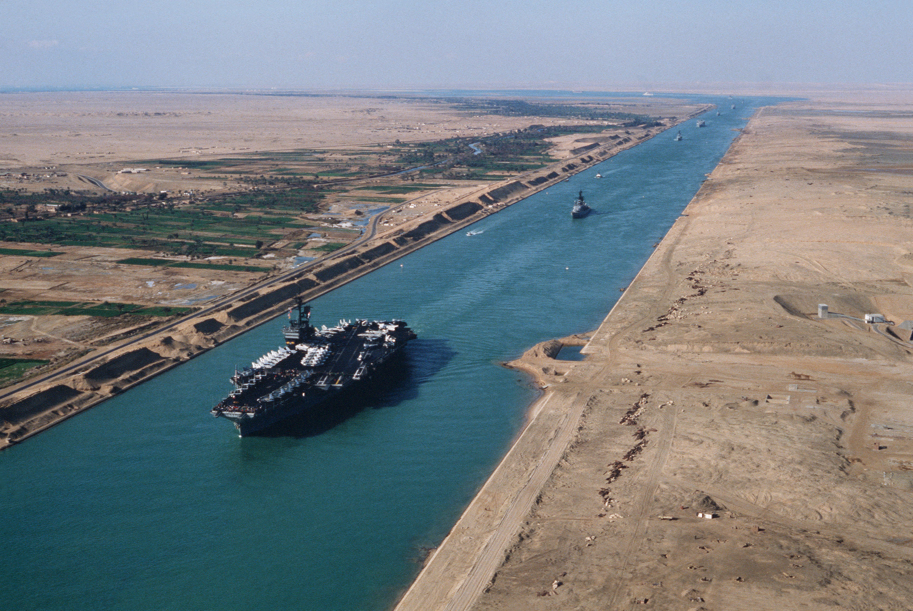
From the Air
The Suez Canal runs 193 km from Port Said (31.26N, 32.30E) on the Mediterranean to Suez (29.97N, 32.55E) on the Gulf of Suez. Its midpoint, near Ismailia and the Great Bitter Lake, lies at approximately 30.58N, 32.31E. From cruising altitude, the canal is unmistakable: a perfectly straight line of water cutting through tan desert, with the green ribbon of the Nile Delta to the west and the Sinai Peninsula to the east. The Great Bitter Lake is the most prominent feature midway along the route. Key airports include Port Said (HEPS), Cairo International (HECA) approximately 120 km to the southwest, and Ras Nasrani/Sharm el-Sheikh (HESH) to the southeast at the tip of the Sinai.