Sumida River
The poet Matsuo Basho chose to live beside the Sumida River, in a hut shaded by a banana tree -- basho in Japanese -- from which he took his pen name. Hokusai painted its bridges at sunset. Hiroshige immortalized it dozens of times across his One Hundred Famous Views of Edo. Every summer since 1733, fireworks have exploded above its dark water between Ryogoku and Asakusa, making the Sumida River Fireworks Festival the oldest of its kind in Japan. This is not merely a river that runs through Tokyo. It is the river that taught Tokyo how to see itself -- in ink, in poetry, in light reflected off water at dusk.
A River Rerouted to Save a Palace
The Sumida branches from the Arakawa River at Iwabuchi in Kita Ward and flows south for 27 kilometers through seven of Tokyo's 23 special wards before emptying into Tokyo Bay. Its tributaries include the Kanda and Shakujii rivers. But the Sumida as it exists today is an engineering artifact. What we call the Sumida was once the main channel of the Arakawa itself. Toward the end of the Meiji era, in the early 20th century, the government manually diverted the Arakawa into a new channel to reduce the catastrophic flooding that threatened central Tokyo -- and, critically, the Imperial Palace in nearby Chiyoda. The old channel kept flowing under a new name, and the Sumida became its own river, carrying the identity of old Edo while the rerouted Arakawa took on the role of flood control. That act of engineering split a single waterway into two distinct narratives.
Canvas of the Floating World
No river in Japan has been painted, printed, and illustrated more obsessively. In the Edo period, when Tokyo was still called Edo, the Sumida formed the eastern boundary of the city's pleasure districts, and ukiyo-e artists documented every angle. Hiroshige painted the Eitai Bridge and Tsukuda Island in 1830, then returned to the river repeatedly for his landmark One Hundred Famous Views of Edo in the 1850s -- the Senju Great Bridge, the nighttime glow of Matsuchiyama, the cherry blossoms at Bokusui embankment. Hokusai captured sunset across the Ryogoku Bridge from Onmayagashi around the same period. Kobayashi Kiyochika painted the river at night in 1881, using Western-influenced techniques to show gas lamps reflecting off the water. Beyond prints, the Sumida gave its name to Sumida Gawa pottery, developed in the Asakusa district in the late 1890s by potter Inoue Ryosai I, whose style of applied figures on flowing glaze became wildly popular with Western collectors for its depictions of dragons, Buddhist disciples, and mythological creatures.
Fireworks, Noh, and a Banana Tree
In 1733, the eighth shogun Tokugawa Yoshimune ordered fireworks launched from barges on the Sumida to pray for the souls lost to a devastating famine and epidemic the year before. That ceremony, the Ryogoku River Opening, continued for over two centuries and was rebranded in 1978 as the Sumida River Fireworks Festival -- today drawing nearly a million spectators who crowd the riverbanks and pack the bridges between Ryogoku and Asakusa each July. The river also shaped Japan's performing arts. The medieval Noh play Sumida-gawa tells the story of a mother searching for her kidnapped son along these banks. When the British composer Benjamin Britten attended a performance in 1956 during a visit to Japan, the play moved him so deeply that he composed Curlew River in 1964, transplanting the story from the Sumida to an English marshland. The kabuki drama Hokaibo, written by Nakawa Shimesuke and first staged in Osaka in 1784, draws from the same river. And Basho, the haiku master, lived right here -- his famous banana tree growing beside his hut on the riverbank, giving him the name the world remembers.
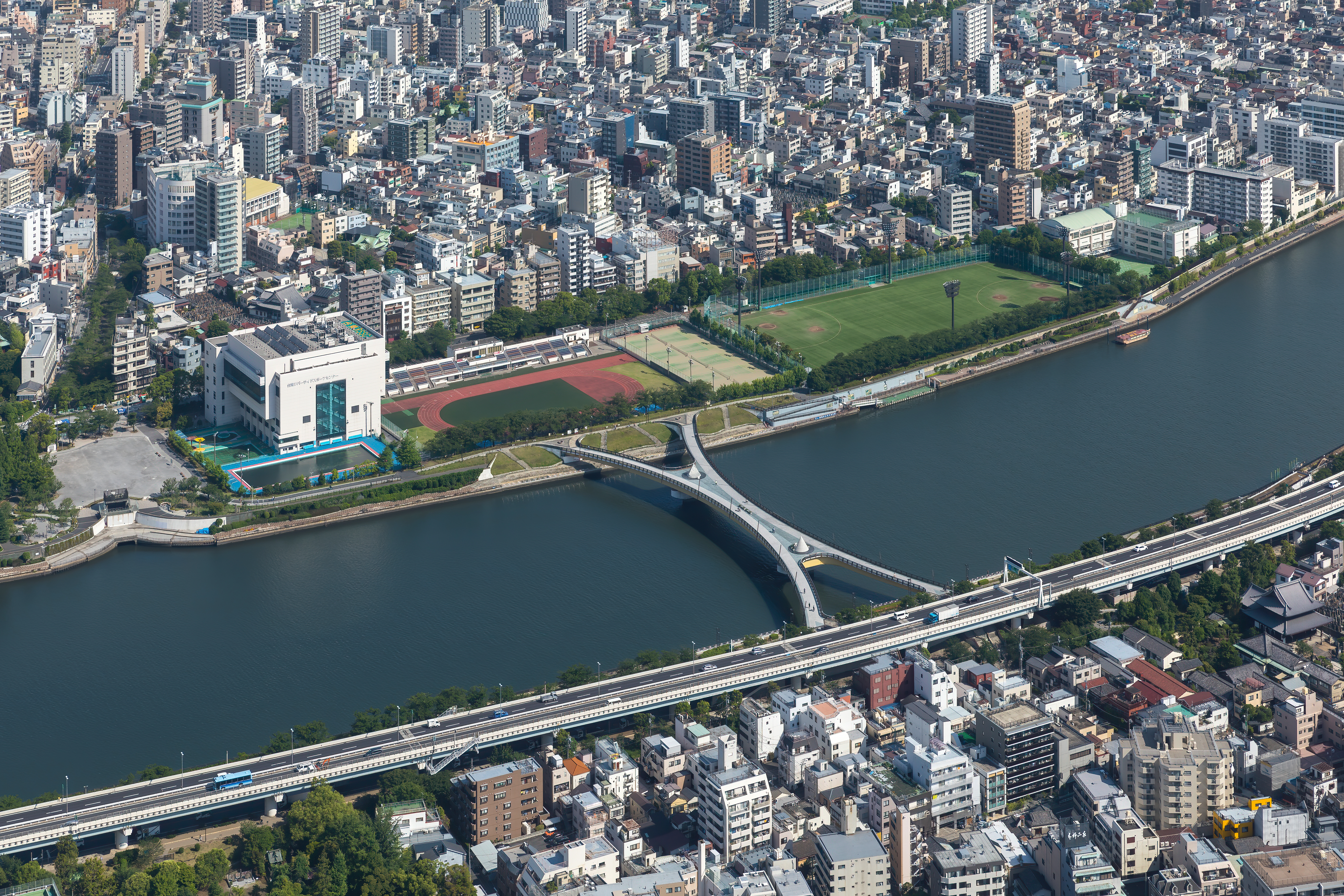
Twenty-Six Bridges, One Per Kilometer
The Sumida runs under 26 bridges across its 27 kilometers, roughly one per kilometer. The oldest lineage belongs to the Ryogoku Bridge, first built in 1659 and rebuilt in its current steel form in 1932 -- a span Hiroshige depicted so many times it became one of the defining images of Edo. The Eitai Bridge dates its origins to 1696, the current structure standing since 1924. The Kachidoki Bridge, built in 1940 to commemorate Japan's victory at Lushun during the Russo-Japanese War, is the only drawbridge on the Sumida -- though it has not been raised since 1970. The Tsukuda Bridge, completed in 1964, was the first bridge built across the Sumida after World War II, connecting Tsukiji to Tsukishima. The newest crossing is Tsukiji Ohashi, which opened in 2018 beside the former site of the famed Tsukiji Fish Market. Each bridge marks a different era of the city's ambitions, from feudal-era timber to postwar reconstruction to 21st-century urban renewal.
The River That Writes the City
From altitude, the Sumida appears as a dark ribbon threading through an impossibly dense urban grid, its curves punctuated by the geometric lines of bridges and the green strips of riverside parks. Tokyo Skytree, at 634 meters the tallest structure in Japan, rises from the western bank in Sumida Ward, casting its shadow across the water in late afternoon. The river bends past Asakusa's Senso-ji temple district, slides under the distinctive red Azuma Bridge, and continues south past the warehouses and apartment towers of Koto Ward before opening into the broad tidal flats of Tokyo Bay. Its banks have been lined with cherry trees since the Edo period, and in spring the pale blossoms drift onto the water -- a sight that Hiroshige, Hokusai, and Basho each captured in their own medium. The Sumida is not Tokyo's longest river or its widest, but it is the one the city cannot stop depicting, century after century.
From the Air
Located at approximately 35.719N, 139.807E (mid-course reference point near Asakusa). The Sumida River is clearly visible from altitude as a sinuous dark waterway running roughly north-south through central Tokyo, threading between dense urban development on both sides. Tokyo Skytree (634 m) on its western bank near Sumida Ward is the dominant landmark. The river empties into Tokyo Bay to the south. Numerous bridges cross at regular intervals. Nearest major airport is Tokyo Haneda (RJTT), approximately 14 km south-southwest. Narita International (RJAA) is about 60 km east-northeast. The Tokyo Imperial Palace grounds are visible roughly 2.5 km to the west-southwest.