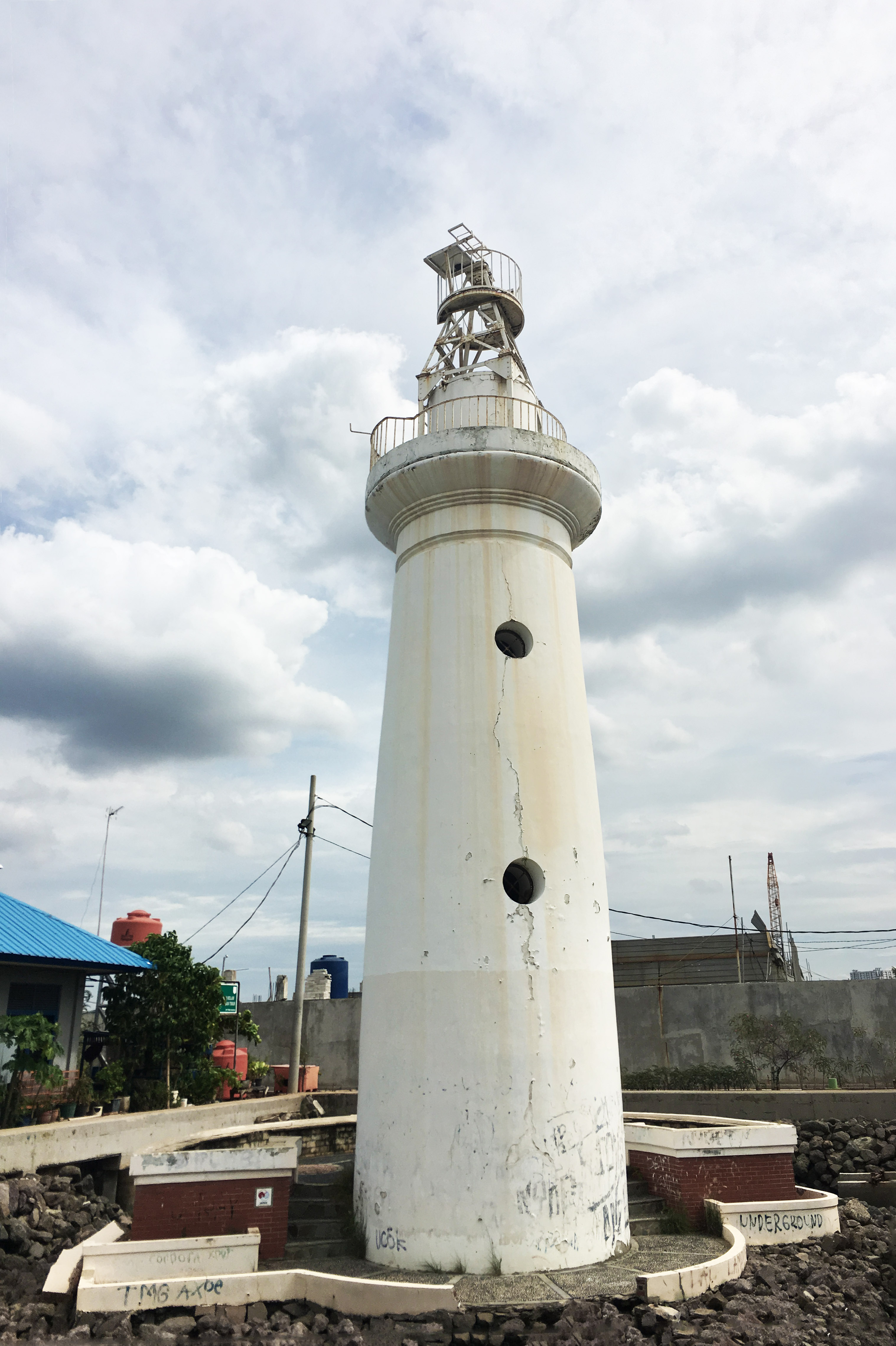
The Lighthouse That Defined Zero
At the base of a white stone tower in North Jakarta, a stone inscribed with Chinese characters marks a point of absolute significance: the zero longitude of Batavia. From this single reference point, Dutch cartographers drew the meridian lines that organized their maps of the entire East Indies archipelago - thousands of islands, millions of hectares of territory, all oriented to a lighthouse at the mouth of a harbor. The Sunda Kelapa Lighthouse was built in 1862 on the western mole of the old port of Batavia, and for a structure that carried such cartographic weight, it is remarkably unassuming: a round stone tower just 16 meters tall, painted white, with a red light flashing every three seconds.
Built on the Sea Itself
In the mid-nineteenth century, the ground where the lighthouse stands today did not exist. It was shallow sea, lying north of the colonial city of Batavia. The Dutch had been struggling with Sunda Kelapa harbor for two centuries - sandbanks built up at its mouth, the canal was too narrow for large vessels, and the tropical climate made maintenance work lethal. By 1860, they completed a mole extending north into the Java Sea, its western arm serving as a jetty to guide ships into the harbor. Two years later, the lighthouse rose on this western mole. It replaced the Menara Syahbandar, an older watchtower located further inland at the mouth of the Ciliwung River. The new light stood at the northernmost point of Batavia, a sentinel positioned roughly 2.5 kilometers north of the Sunda Kelapa port itself - the first thing approaching sailors would see.
The Measure of All Things
The zero-longitude stone at the lighthouse's base deserves attention, because it represents something more than navigational convenience. Before international agreements standardized the Greenwich meridian in 1884, colonial powers often established their own prime meridians. The Dutch chose this point - the tip of the Batavia mole, the entrance to their most important port in Asia - as the reference from which all East Indies cartography would be measured. The stone bears Chinese writing, a reflection of the Chinese community's deep involvement in Batavia's commercial and maritime life. Alongside the zero-longitude marker, the lighthouse also houses an antique marine chronometer, the kind of precision instrument that made longitude calculation possible at sea. Together, these artifacts make the lighthouse less a navigational aid and more a museum of the science that enabled colonial expansion.
Overtaken and Overlooked
The lighthouse served its original purpose for well over a century, its red flash guiding vessels into the old harbor until the 1990s. But by then, the world had changed around it several times over. The completion of the Tanjung Priok port in 1885 diverted major shipping traffic nine kilometers to the east. The lighthouse kept operating for the smaller vessels that continued to use Sunda Kelapa, but its strategic importance diminished with each passing decade. The auxiliary buildings that once surrounded it - the guardhouse, the lighthouse keeper's quarters - were demolished at some point, leaving the tower standing alone. Then came the redevelopment of the Muara Baru fish harbor complex, which swallowed the lighthouse's surroundings. New office buildings and a tall seawall now partly obscure the tower. The ground around it has been raised and leveled, so the lighthouse sits in a kind of depression, lower than the terrain it once dominated.
Still Standing, Barely Visible
The lighthouse was recently restored, but its situation remains paradoxical. A structure that once marked the northernmost extent of an entire colonial capital now hides behind modern construction in a working fish market. Of its original three windows, only two survive. The focal plane - the height at which the light sits - reaches 17 meters, barely above the rooflines of the commercial buildings that crowd in on all sides. Yet the tower endures, and so do the objects inside it: the chronometer, the zero-longitude stone. These are not decorative relics. They are instruments that shaped the way an empire understood geography, the tools with which the Dutch imposed a grid of measurement on an archipelago of seventeen thousand islands. The lighthouse is easy to miss today, hemmed in by the infrastructure of a modern city that has long since outgrown it. But the stone at its base still marks the point from which all distances were once measured.
From the Air
Located at 6.105S, 106.805E on the waterfront of the Muara Baru fish harbor complex in North Jakarta. The lighthouse is a small white round tower, difficult to spot from altitude due to surrounding modern buildings and the tall seawall. It sits approximately 2.5 km north of the old Sunda Kelapa port, which is identifiable by the rows of traditional pinisi sailing ships. The Kota Tua (Old Town) historic district with Fatahillah Square lies roughly 3 km to the south. Nearest major airport is Soekarno-Hatta International (WIII), about 23 km northwest. Halim Perdanakusuma Airport (WIHH) is approximately 19 km southeast.