Sundarbans
The name means "beautiful forest," though some linguists trace it instead to the sundri tree that dominates its canopy. Either way, the Sundarbans earns both readings. Spanning the vast Ganges Delta where three of Asia's mightiest rivers -- the Ganges, Brahmaputra, and Meghna -- empty into the Bay of Bengal, this is the largest mangrove forest on Earth, a tidal labyrinth of channels, mudflats, and salt-tolerant trees that stretches across India's West Bengal and Bangladesh's Khulna Division. Four protected areas within it hold UNESCO World Heritage status. And yet this is no pristine wilderness frozen in time. The tides here are so extreme that roughly a third of the Sundarbans disappears underwater and reappears again every single day.
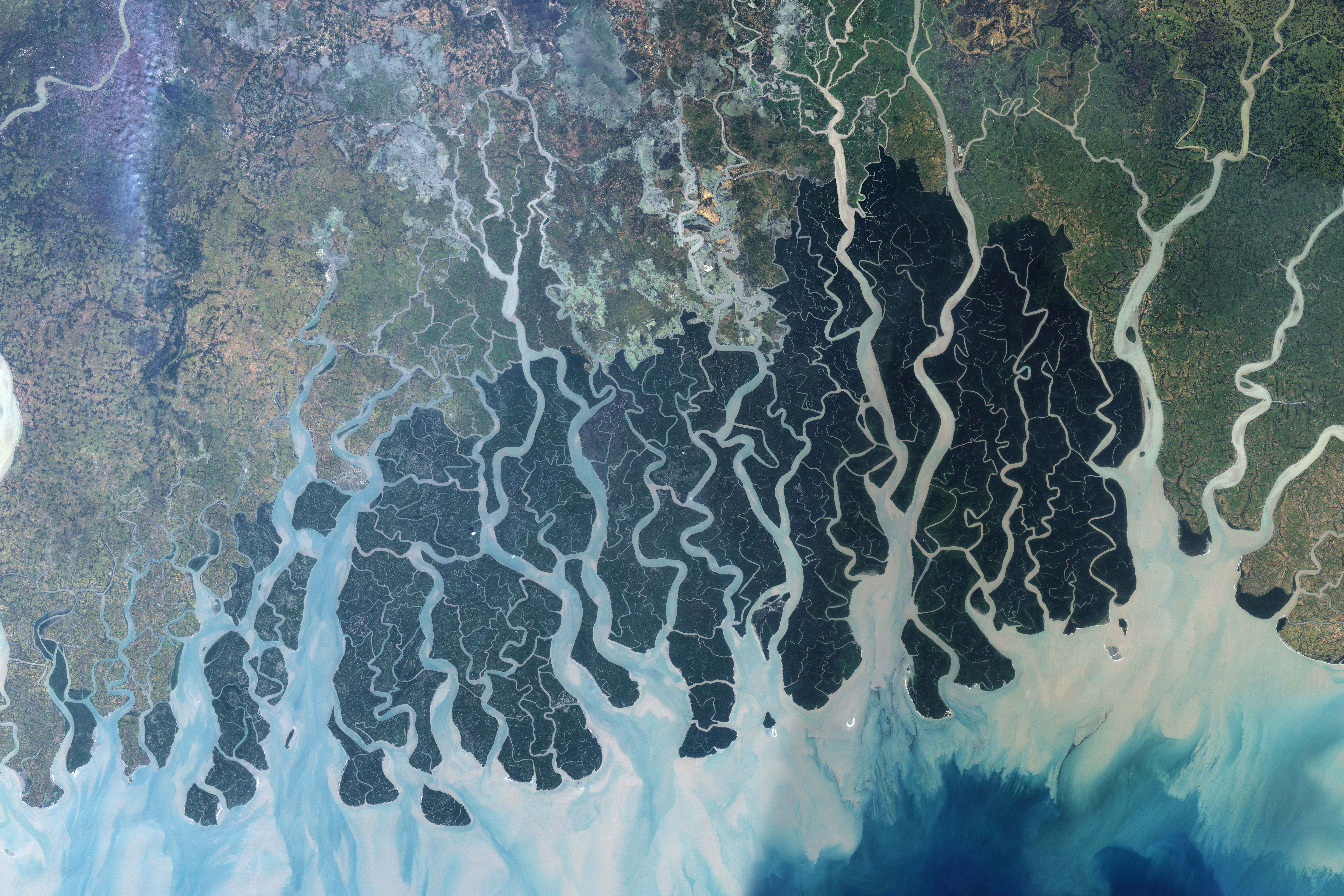
Where Rivers Become the Sea
The Sundarbans sits at the mouth of the Ganges-Brahmaputra-Meghna super-confluence, one of the most geologically active deltas on the planet. Freshwater from the Himalayan glaciers meets the salt of the Bay of Bengal in a constantly shifting interface, and the result is an ecosystem unlike any other. The interconnected waterways make almost every corner of the forest accessible by boat, yet navigation remains treacherous -- channels migrate, sandbars appear overnight, and the forest itself advances and retreats with each tidal cycle. Pioneer species like Sonneratia colonize newly accreted mud, followed by Avicennia and Nypa palms, until eventually the sundri trees establish themselves on higher ground. This slow-motion ecological succession has been building land for millennia, one sediment deposit at a time.
The Tiger That Swims
This is the only mangrove forest in the world that harbors the Bengal tiger. Unlike their upland cousins, Sundarbans tigers are accomplished swimmers, crossing tidal channels to hunt chital deer, wild boar, and rhesus macaques on scattered islands. According to the 2015 Bangladesh and 2011 India censuses, approximately 180 tigers survive here -- 106 in Bangladesh, 74 in India. The earlier estimates, based on pugmark counting, ran higher; camera traps have given a more sobering picture. Human-tiger conflict remains intense. Between 2000 and 2010, around 40 people were killed by tigers in the Sundarbans. Honey collectors, fishermen, and woodcutters working the forest's interior face the constant reality that they share these waterways with the Indo-Pacific region's largest land predator.
A Living Inventory
Beyond the tigers, the Sundarbans supports a staggering catalog of life: 290 bird species, 120 species of fish, 42 mammals, 35 reptiles, and eight amphibians -- 453 wildlife species in all. Twenty-six of the world's fifty broad mangrove species grow here. The canopy is dominated by sundri and gewa trees, but the full botanical inventory, first cataloged by David Prain in 1903, runs to 245 genera and 334 plant species. Fishing cats stalk the waterline. Saltwater crocodiles patrol the estuaries. Irrawaddy and Ganges river dolphins surface in the deeper channels. Yet despite a total ban on killing or capturing wildlife other than fish and some invertebrates, biodiversity has been declining steadily. Two amphibians, 14 reptiles, 25 bird species, and five mammals are now classified as endangered.
Centuries of Human Entanglement
Human presence in the Sundarbans traces back to the Mauryan era in the fourth to second centuries BCE. Ruins of an abandoned city in the Baghmara Forest Block are attributed to Chand Sadagar, a pre-Mauryan figure from Bengali folklore. During the Mughal period, local rulers leased forest tracts for settlement. The British East India Company acquired proprietary rights in 1757, completed mapping by 1764, and established the first Forest Management Division in 1869. A large portion was declared reserved forest in 1875 under the Indian Forest Act. Two centuries ago, the Sundarbans covered roughly 16,700 square kilometers. Today, it has shrunk to about a third of that original extent -- a measure of just how deeply human activity has reshaped this landscape even as people remain dependent on the forest for their livelihoods.
A Forest Under Siege
The threats converging on the Sundarbans read like a catalog of modern environmental crises. Cyclone Sidr damaged 40 percent of the forest in 2007. Cyclone Aila devastated it again in 2009, affecting at least 100,000 people. Rising sea levels driven by climate change are increasing salinity, while reduced freshwater flow from upstream dams compounds the problem. The Indian Sundarbans were assessed as endangered under the IUCN Red List of Ecosystems framework in 2020. A proposed coal-fired power station at Rampal, just upstream of the forest in Bangladesh, drew a critical 2016 UNESCO report warning of further damage. The mangroves serve as a natural barrier protecting millions of people in Kolkata, Khulna, and the port city of Mongla from cyclone-induced flooding. Losing them would expose some of the most densely populated land on Earth to the full force of the Bay of Bengal.
From the Air
Centered at 21.75N, 88.75E in the Ganges Delta. From altitude, the Sundarbans appears as a vast green labyrinth of waterways and islands between the Bay of Bengal and the cultivated mainland. The forest boundary is sharp against agricultural land to the north. Nearest major airport is Netaji Subhas Chandra Bose International (VECC) in Kolkata, approximately 100 km north. Mongla Port (near VGMG) sits on the western edge of the Bangladeshi portion. Best viewed at 5,000-15,000 feet to appreciate the tidal channel network and the scale of the delta.