Sundial Bridge at Turtle Bay
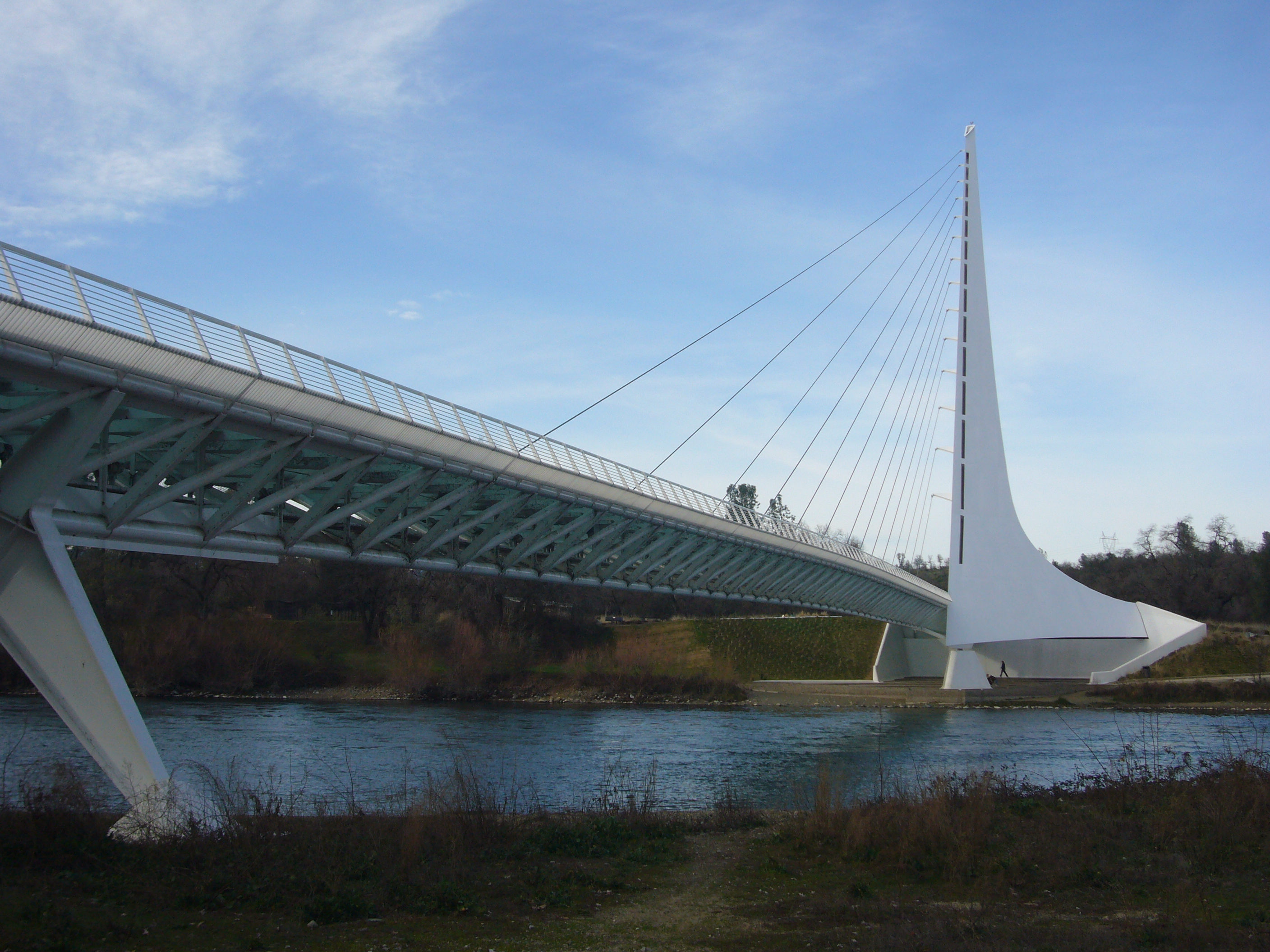
At precisely noon on the summer solstice, the shadow of a 217-foot white tower falls exactly on the midday marker. This is no accident. The Sundial Bridge at Turtle Bay was designed by Spanish architect Santiago Calatrava to function as a massive timepiece, its cantilevered mast serving as the gnomon that ancient sundial makers would recognize. The bridge cost $23.5 million and took years longer than planned to complete, dividing Redding between residents who saw a bold statement about the city's future and those who wanted a more traditional covered bridge. The bold vision won. Today, this gleaming structure spanning the Sacramento River has become the defining symbol of a Northern California city that wagered big on art and architecture.
Time Made Visible
The support tower rises at a precise 42-degree angle, pointing due north, though the bridge sits at approximately 40.59 degrees latitude - a slight mismatch that means the sundial is perfectly accurate only on the summer solstice. The rest of the year, there is a small discrepancy. But watch the shadow's tip: it moves at roughly one foot per minute, fast enough to see the Earth's rotation with the naked eye. North of the bridge, a large dial marked with time indicators catches the shadow. The time displayed is Pacific Daylight Time. Though it has been billed as the world's largest sundial, that claim is disputed - Taipei 101 and its adjoining park create a larger one - but the Sundial Bridge remains the most dramatic.
Calatrava's Signature
Santiago Calatrava pioneered this type of structure with his Puente del Alamillo in Seville, Spain in 1992. Traditional cable-stayed bridges balance forces symmetrically, with cables pulling equally on both sides of the support tower. Calatrava's cantilever design loads cables on only one side, with the angled tower itself resisting the asymmetric forces. It is less structurally efficient, but the architectural effect is striking - the bridge appears to leap across the water. The cables divide the 700-foot span into a major and minor path. The deck surface is translucent structural glass from Quebec, illuminated from below, glowing aquamarine after dark. The steel structure was fabricated in Vancouver, Washington and trucked to Redding in sections. White tile from Spain decorates the sundial plaza.
Salmon Beneath the Span
One design requirement shaped everything: the bridge could not touch the Sacramento River. Below these waters, salmon spawn - the same steelhead and rainbow trout that fishermen in drift boats still chase beneath the bridge today. Every cable, every foundation, every structural element had to respect that biological imperative. The result is a bridge that soars above the river in a single graceful leap. The Sundial Bridge connects the north and south areas of Turtle Bay Exploration Park, a complex of environmental, art, and history museums plus the McConnell Arboretum and Gardens. It also serves as the gateway to the Sacramento River Trail. To the north, Mount Shasta rises on clear days; Shasta Bally is visible to the west, upriver.
The Gamble That Paid Off
When the bridge opened in 2004 - three years late and millions over budget - critics still questioned whether a small city like Redding needed such an extravagant pedestrian crossing. A group of doctors, lawyers, and professionals had championed the project; other residents preferred something more modest and "folksy." Tourism settled the argument. In the fiscal year following the grand opening, Turtle Bay Exploration Park saw a 42 percent increase in visitors. The bridge became Redding's icon, its image appearing on everything from city marketing to a physics textbook cover demonstrating how structures resist wind and gravity. Each October since 2009, the bridge glows pink for Think Pink Day, raising awareness for breast cancer detection.
From the Air
Located at 40.5922N, 122.3775W in Redding, California, spanning the Sacramento River at Turtle Bay. The bridge's white cable-stayed structure and angled tower are distinctive from the air, especially the translucent glass deck that glows at night. Mount Shasta (14,179 ft) visible to the north on clear days; Shasta Bally prominent to the west. Nearest airports: Redding Municipal (RDD) approximately 4nm southeast, Benton Field (O85) 7nm south. Best viewing at lower altitudes in morning or afternoon light when the sundial shadow is visible on the north dial.