Taal Volcano
Imagine a lake that fills an ancient caldera. Now imagine an island rising from the center of that lake -- an island that is itself an active volcano, with its own crater lake inside. This is Taal, the second most active volcano in the Philippines, a geological nesting doll located just 50 kilometers south of Manila. With 39 recorded historical eruptions, Taal is not a relic of deep time. It erupted in January 2020, killing 39 people. It erupted again in 2021, 2022, 2024, 2025, and as recently as January 2026. The question with Taal is never whether it will erupt again, but when.
The Lake That Hides a Monster
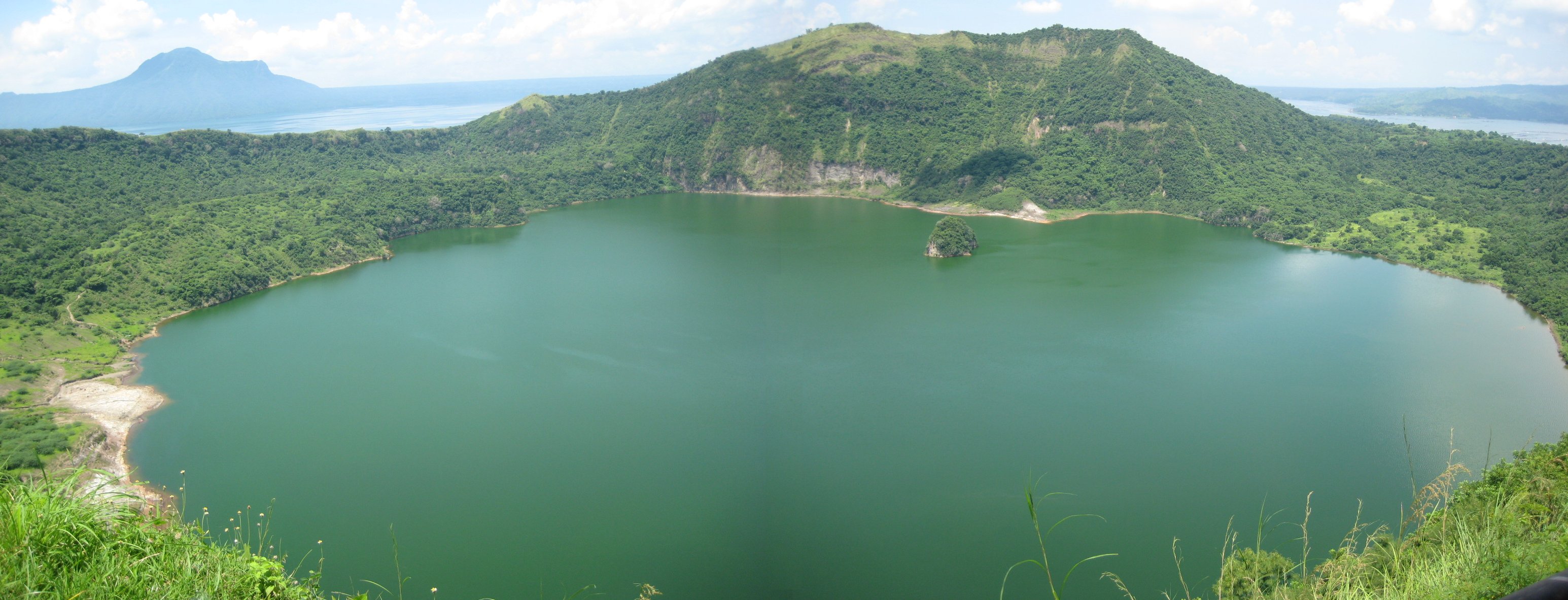
Taal Lake fills a caldera formed by prehistoric eruptions of extraordinary violence -- events classified at VEI-6 and VEI-7, powerful enough to reshape the surrounding landscape. The lake stretches across Batangas province, deceptively calm, its surface reflecting the green hills that rim the caldera. Volcano Island rises near the center, roughly five kilometers across, its slopes scarred by centuries of explosive activity. The main crater on Volcano Island contains its own lake, creating the famous nested structure: a crater lake on an island in a lake in a caldera. Fishing communities once lived on Volcano Island itself, their daily lives unfolding on ground that could -- and repeatedly did -- turn lethal beneath their feet. The Philippine government has since declared the island a permanent danger zone, though enforcement remains an ongoing challenge.
The Afternoon Everything Changed
On the afternoon of January 12, 2020, Taal erupted. The Philippine Institute of Volcanology and Seismology escalated the alert from Level 2 to Level 4 as a Plinian eruption column rocketed skyward from Volcano Island's main crater. Scoria fragments and ash rained across Calabarzon, Metro Manila, and parts of Central Luzon and Pangasinan -- regions home to millions. Volcanic lightning crackled through the ash cloud, an eerie spectacle visible from the capital. The eruption progressed into a magmatic phase, producing lava fountains accompanied by thunder. Schools closed, flights were cancelled, and forced evacuations pulled thousands from the danger zone. By January 26, activity had decreased enough to lower the alert to Level 3, and by February 14 to Level 2. Thirty-nine people died, many because they refused to leave their homes or suffered health emergencies during the chaotic evacuation.
A Volcano That Never Sleeps
What makes Taal particularly unnerving is its refusal to stay quiet. The 2020 eruption was not a singular event but the opening act of a period of sustained unrest that continues to this day. In July 2021, Taal erupted again. In early 2022, nine phreatomagmatic bursts rattled the main crater in two days, and a March eruption displaced nearly 4,000 people. Sulfur dioxide emissions have become a chronic problem: in August 2022, emissions spiked to 12,125 tons in a single day, blanketing Batangas and surrounding towns in volcanic smog -- a choking haze called vog. Throughout 2023 and 2024, vog forced repeated school suspensions across Batangas and neighboring provinces. Phreatic and phreatomagmatic eruptions continued through 2025 and into January 2026, each one a reminder that the magma system beneath Taal Lake remains pressurized and restless.
Reading the Warning Signs
PHIVOLCS operates a dedicated alert system for Taal, one of only six Philippine volcanoes with its own distinct warning scale, ranging from Level 0 to Level 5. Scientists monitor an arsenal of precursors: seismic tremors, ground inflation measured by deformation surveys, rising temperatures in the crater lake, shifts in water pH, increased carbon dioxide and sulfur dioxide emissions, the appearance of new fumaroles and mudpots, fish die-offs, and the drying of vegetation. A solar-powered remote monitoring station sits on Volcano Island itself, gathering data from a place too dangerous for permanent human habitation. In 1994, volcanologists detected a sixfold increase in radon gas concentration in the island's soil. Twenty-two days later, a magnitude 7.1 earthquake struck off the coast of Mindoro, 50 kilometers to the south. Typhoons were ruled out as the cause -- the radon spike pointed to deep tectonic stress accumulation. Taal, it seems, telegraphs not only its own eruptions but the seismic tension of the region itself.
Living on the Edge of the Caldera
Despite the danger, millions of people live within the broader Taal Volcano region. Batangas province is densely populated, and the lake's fertile shores support agriculture and fishing communities that have coexisted with the volcano for generations. The landscape is stunningly beautiful: the green caldera walls, the lake shimmering in tropical light, the dark cone of Volcano Island rising from the water. Taal is designated both a national geological monument and a Decade Volcano -- one of sixteen volcanoes worldwide identified by the International Association of Volcanology as deserving particular study because of their history of destructive eruptions and proximity to populated areas. From above, the nested structure is unmistakable: the caldera rim, the lake, the island, the crater, the inner lake. It is a geography that invites wonder and demands respect in equal measure.
From the Air
Located at 14.01N, 120.99E in Batangas province, Philippines, approximately 50 km south of Manila. The caldera and Taal Lake are unmistakable from altitude -- look for the large lake with Volcano Island at its center. The nested crater-within-island-within-lake structure is best appreciated from 5,000-10,000 ft. Nearest major airport is Ninoy Aquino International Airport (RPLL) to the north. Caution: volcanic activity may produce ash plumes and sulfur dioxide emissions; check PHIVOLCS alerts before overflying at low altitude.