Tabubil
Eight meters of rain. That is the average annual precipitation at Tabubil, Papua New Guinea, and in wet years the total has hit ten. Nothing about a town exists without reckoning with that fact first. Roads are sealed and gridded with floodways so the water can sluice over the bitumen without stopping traffic. Houses sit up on stilts, with the undersides turned into church halls and meeting rooms. Snakes stretch themselves across the warm asphalt to steal heat from the only surface in town that is ever dry. And all of it, all ten thousand people and their four churches and their Dash 8 runway, exists because a mountain 30 kilometers to the northwest turned out to be made of copper.
Before the Outside World Arrived
The Star Mountains are one of the most remote pieces of terrain in the Pacific, a rumpled, cloud-wrapped highland where the Min people lived for centuries with only brief and second-hand contact with anyone from outside. Tradition holds that the Min were pushed north long ago by wars with the Gogodala peoples of the central Fly plain. Before the 1940s, even colonial mapmakers could not say with certainty how many Min there were, or where they lived. In 1943, during World War II, United States Army Air Forces gliders landed in the Star Mountains to establish an airstrip at what is now Telefomin, about 25 kilometers northeast of the future site of Tabubil. The Telefolmin were at the time engaged in tribal warfare with their neighbors, the Falamin and Tifalmin, and the arrival of Americans bringing Western goods and services — backed up by Australian colonial administrators who actively suppressed intergroup fighting — produced a rapid cessation of hostilities. Trade, which had been throttled by conflict, flourished.
A Camp Around an Airstrip
Tabubil itself was not a town. It was a drilling camp. In the 1970s the Kennecott Copper Corporation, hunting the mineral deposit that would become the Ok Tedi Mine, set up a base of operations around a rough airstrip at a clearing that had nothing else to recommend it. In 1976, the Australian mining giant BHP opened negotiations with the Papua New Guinea government to take over the camp and turn it into a gold-mining town; the deal closed in 1980. A year later, Ok Tedi Mining was incorporated. Tabubil grew. The Mission Aviation Fellowship moved in to service the new airstrip. The YMCA and YWCA became the main civic organizations. Four major churches took root, and many more small congregations met beneath the B-type and C-type houses on stilts. The town's central Spine Road — known locally as Dead End Road — was blocked to cars by boulders at each intersection and became a busy, safe pedestrian market.
Living in the Wettest Town
Tabubil is unofficially considered one of the wettest inhabited places on Earth. The climate sits under the Intertropical Convergence Zone, which hangs over the equator and delivers rain almost daily. Because the town is well inside the tropics and protected by terrain, cyclones do not reach it. The rain does everything else. Floodway after floodway crosses the sealed roads. Airstrip operations at Tabubil Airport — a 1,280-meter dirt and gravel runway with IATA code TBG — depend on weather windows that can close for days. Dash 8s from Asia Pacific Airlines fly daily to Port Moresby and Mount Hagen, and tri-weekly to Cairns, Australia. Before the Dash 8s, it was a Beechcraft Super King Air 200 shuttling mine traffic. The highway to the port of Kiunga, on the upper Fly River, is the other lifeline; it parallels the Ok Tedi River and is regularly eaten away by the river it follows.
A Company Town, Mostly
BHP held the controlling interest until 2002, when the company — under international pressure over the downstream environmental disaster on the Ok Tedi River — transferred its stake to the PNG Sustainable Development Program. In 2013 the PNG government nationalized the mine outright. Tabubil, through all the changes in ownership, remained a company town. Its population at the 2011 census was 10,270, making it the largest settlement in Western Province despite the provincial capital at Daru being similar in size. The town's amenities — the international school, the Cloudlands hotel, the OTM headquarters known locally as the White House — exist because the mine exists. So do its four churches, its local television station OTV, and its shortwave broadcaster Radio Fly on 3915 and 5960 kHz.
Walking to the Next Village
For many people in the surrounding country, walking remains the standard way to get anywhere. Locals can tell a visitor exactly how many days it will take to reach a given village on foot. Many local airstrips have fallen into disrepair — their maintenance is the responsibility of underfunded Local Level Governments — so even where flight used to be possible, it often isn't now. Tabubil sits in a strange position: a modernized, serviced, computer-owning town (though most residents rarely use the internet) perched at the end of a gravel highway, surrounded by country where the fastest connection to the next community is still your own feet on a forest track.
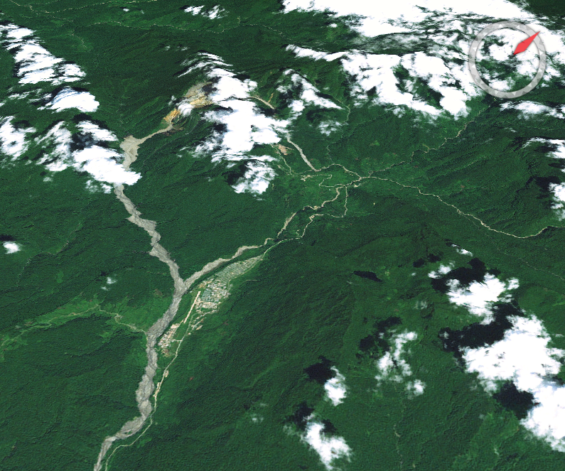
From the Air
Located at 5.28 S, 141.23 E in the Star Mountains of Western Province, Papua New Guinea, at an elevation of around 500 meters, with Mount Fubilan rising above 2,000 meters 30 km to the northwest. Tabubil Airport (TBG/AYTB) has a 1,280-meter dirt and gravel runway served by Dash 8s from Port Moresby (POM/AYPY) and Mount Hagen (HGU/AYMH), plus tri-weekly flights to Cairns (CNS). Weather is the limiting factor: cloud and heavy rain close operations regularly. Early-morning flying gives the only reliable windows. At 5,000 to 7,000 feet AGL, the scale of the town, the airstrip, and the nearby Ok Tedi pit becomes visible.