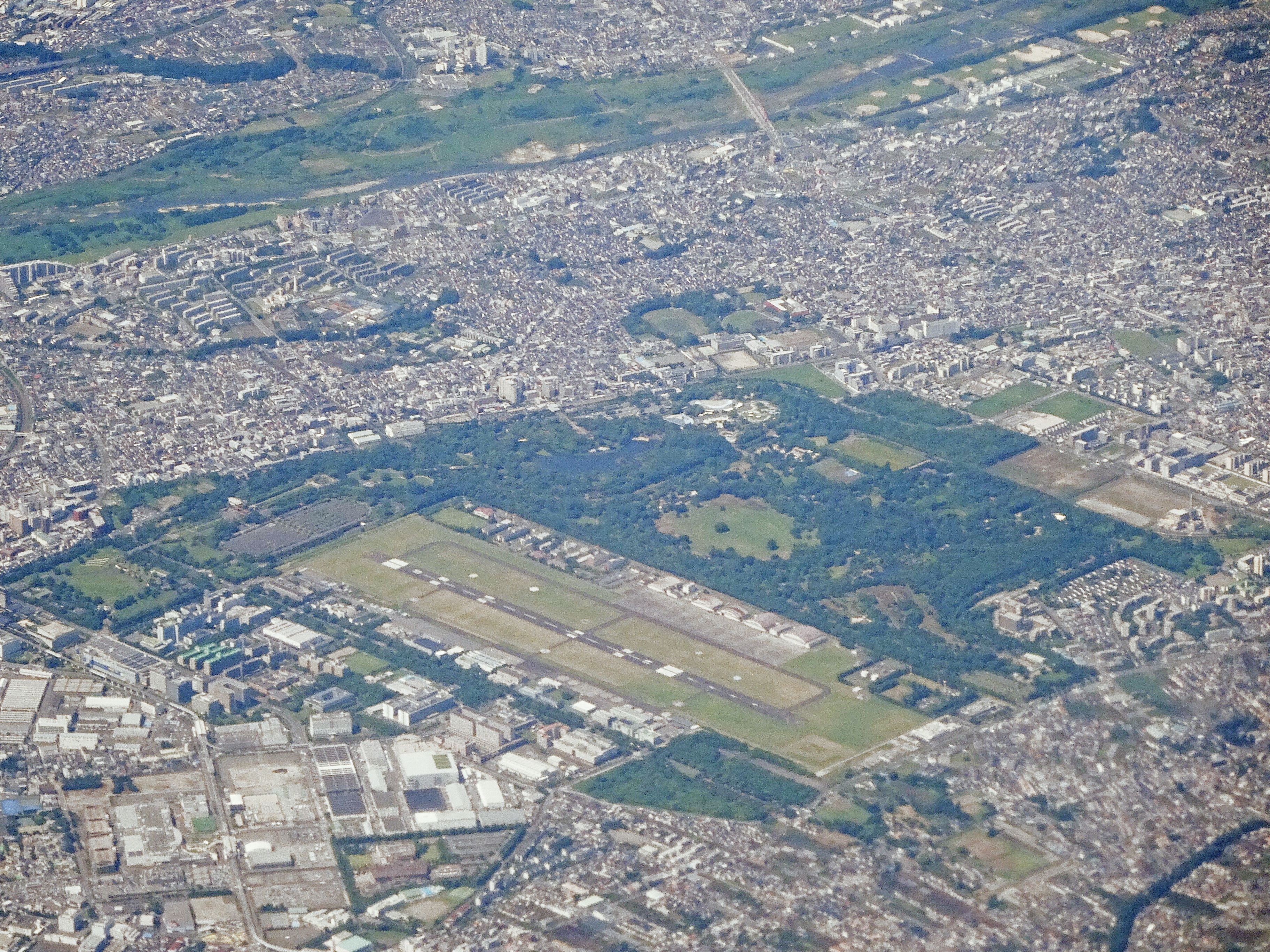
Tachikawa Airfield: Tokyo's Secret Bunker City
On June 18, 1953, a U.S. Air Force C-124 Globemaster II lumbered off the runway at Tachikawa, lost an engine seconds after takeoff, and crashed into a field near the base. All 129 people aboard died -- at the time, the deadliest air disaster in history. The runway that killed them was too short for the planes that needed it, and the neighborhood beyond the fence had grown so close that extending it would spark riots. That tension between a military airfield and the sprawling city that swallowed it defines Tachikawa's century-long story. What began as an Imperial Guard outpost on flat farmland west of Tokyo became Japan's first commercial airport, then the busiest American air transport hub in the Pacific, and finally -- after the last aircraft departed and the runways went quiet -- something stranger still: a disaster-preparedness fortress built atop a network of wartime tunnels, enlarged to sustain 5,000 people underground for an entire year.
Biplanes and the Birth of Japanese Aviation
The Imperial Guard chose this stretch of flat ground along the Chuo Main Line railway in western Tokyo after considering sites in Sagamihara, Kawagoe, and Kodaira. Proximity to central Tokyo, good rail access, and sparse population made Tachikawa ideal. On March 14, 1922, a flying squadron of Farman III biplanes, a balloon squadron, and a material depot relocated here from Tokorozawa under the command of Colonel Arikawa, with Captain Yoshitoshi Tokugawa leading the flying squadron. Seven years later, in 1929, Japan Air Transport inaugurated the country's first scheduled commercial air service from Tachikawa -- a three-hour flight to Osaka. Routes soon extended to Dalian and Seoul. By the late 1930s, the Tachikawa Aircraft company was employing thousands and would ultimately produce more than 6,000 military aircraft -- fighters, troop carriers, and bombers -- with prototypes designed and tested on site.
From Ruins to Round-the-Clock Operations
American B-29 Superfortresses hammered Tachikawa in April and June 1945, reducing the airfield to rubble. The Shintentai, an anti-aircraft kamikaze unit, defended the facilities but could not prevent the destruction. When U.S. forces arrived on September 5, 1945, they found an airfield in shambles. Air Transport Command cleaned up the wreckage, and by January 1946, C-47 Skytrains and C-46 Commandos were operational. Larger C-54 Skymasters followed by April. Tachikawa became the primary Military Air Transport Service hub for the Western Pacific, running flights 24 hours a day to Hickam Field in Hawaii, Clark Air Base in the Philippines, and onward to Saigon, Bangkok, Guam, and Karachi. During the Korean War, the pace became relentless: a typical flight carried 35,000 pounds of hand grenades south and returned with 80 wounded soldiers bound for the base hospital. For thousands of servicemen rotating through the Far East, Tachikawa was the gateway.
The Sunagawa Struggle
The 1953 air disaster underscored Tachikawa's fundamental problem: the runway was too short for heavy jet-age transports. The U.S. military proposed extending it into the neighboring farming town of Sunagawa. On July 8, 1957, farmers, students, and labor activists clashed with police in what became known as the Sunagawa Struggle -- a pivotal moment in Japan's postwar anti-base movement that rippled across the country and fueled opposition to the U.S. military presence. The extension was canceled, though the announcement did not come until 1968. Meanwhile, Tokyo's suburbs had encircled the base, making heavy transport operations increasingly untenable. Operations began shifting to nearby Yokota Air Base in 1964, and by 1969 flying activity at Tachikawa had effectively ceased. The base lingered as military housing and a hospital through the Vietnam era before closing officially on September 30, 1977, when it was returned to the Japanese government.
Cherry Blossoms Over the Bunkers
Walk through Tachikawa today and you would never guess the ground beneath your feet holds a small underground city. The central portion of the old airfield is now Showa Memorial Park, a verdant expanse opened in 1983 and named for Emperor Hirohito. Cherry trees bloom where transport planes once idled. An IKEA store and city hall occupy other patches of the former base. But deeper in the complex, the Japan Ground Self-Defense Force maintains Camp Tachikawa, home of the Eastern Army Aviation Group and its fleet of UH-1J Iroquois and Kawasaki OH-1 helicopters. The Tachikawa Disaster-Preparedness Base serves as Japan's alternate seat of national government -- a command center the government would use if forced to relocate during a catastrophic event. Beneath it all lies a network of tunnels originally dug by the Imperial Japanese military during World War II to shelter aircraft from American bombing. The U.S. military used them for storage from 1945 to 1977. Since reversion, Japan has enlarged the tunnel and bunker system to accommodate up to 5,000 people and sustain them for a full year if necessary.
Three Flags, One Runway
Tachikawa has served under three flags in a single century. It began as an Imperial Guard aviation outpost, became one of America's most critical Cold War logistics bases, and now functions as Japan's emergency nerve center. The annual Tachikawa Air Show still fills the sky with helicopters -- GSDF, Tokyo Police, and Tokyo Fire Department machines performing formation flights where Farman biplanes once wobbled aloft. The agencies gathered at the disaster-preparedness base read like a directory of the Japanese government: the Cabinet Office, Coast Guard, Ministry of Agriculture, National Hospital Organization, Red Cross. It is, in essence, a shadow government campus hidden in plain sight among parks, shopping centers, and apartment blocks in western Tokyo -- ready for the disaster everyone hopes never comes.
From the Air
Located at 35.71N, 139.40E in western Tokyo, the former Tachikawa Airfield site is visible as a large open area amid dense urban sprawl. Showa Memorial Park occupies the central portion and is identifiable by its green expanse and distinctive canal gardens. The GSDF heliport is active on the western side -- monitor appropriate frequencies. Yokota Air Base (RJTY) lies approximately 5 nautical miles to the northwest. Best viewed at 3,000-5,000 feet AGL approaching from the south, where the contrast between the park's open space and surrounding urban density is most dramatic.