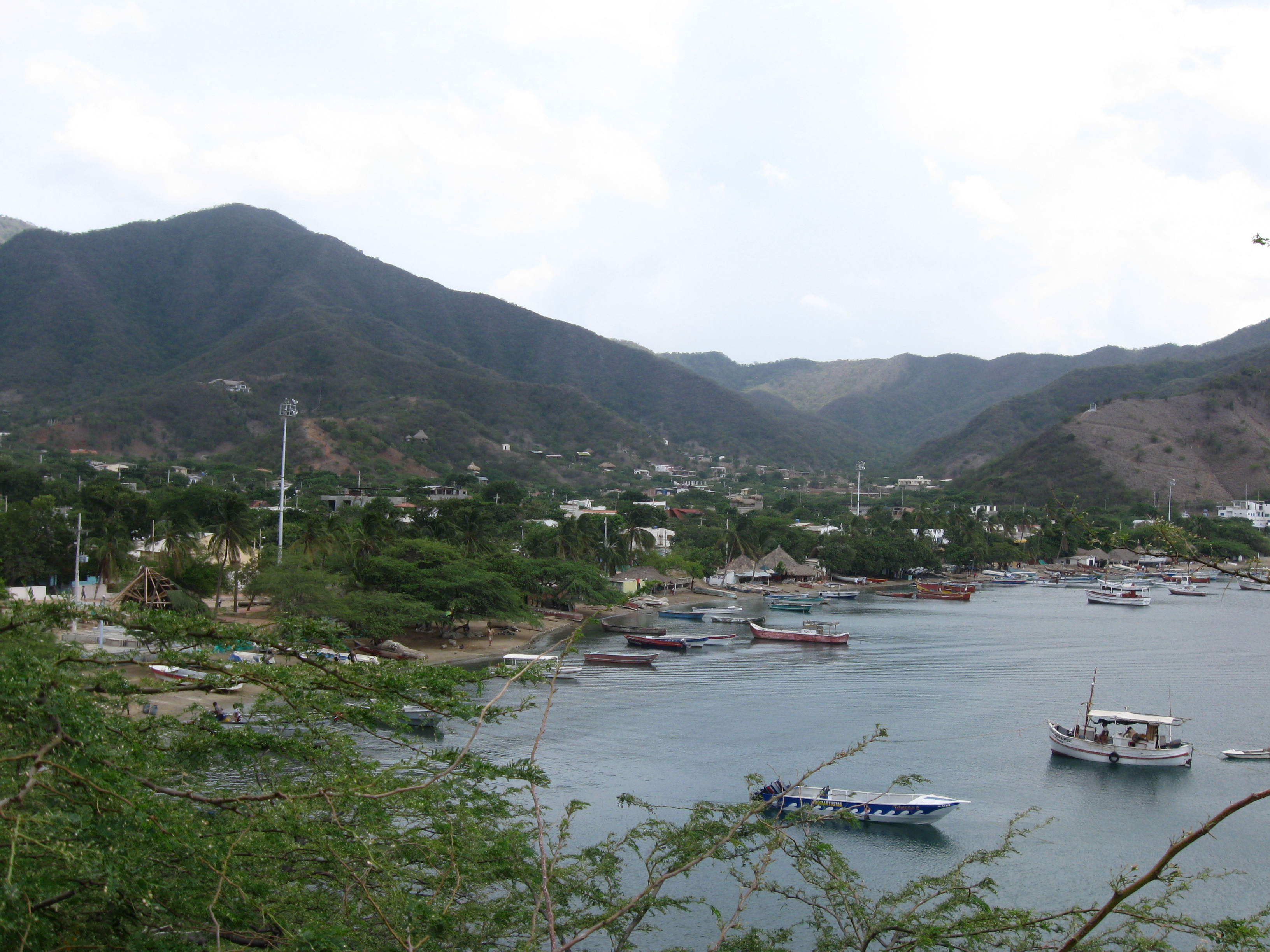
Taganga
The name itself is a kind of argument. It might come from the Taganga people who lived here before the Spanish arrived, from the words ta and gunmy -- meaning "snake mountain range" -- or from the Tairona words ta and ganga, "entrance of the sea." Nobody has settled the question, and in a place where a tectonic fault line literally divides the village from the national park next door, a little uncertainty seems appropriate. Taganga is a fishing village on the Caribbean coast of Colombia, three kilometers north of Santa Marta. Both were founded by Rodrigo de Bastidas on July 29, 1525, making them among the oldest European settlements still standing in the Americas.
Where Mountains Meet the Sea
Taganga occupies roughly one square kilometer at the northwestern base of the Sierra Nevada de Santa Marta, a triangular mountain range that rises to the twin peaks of Pico Cristobal Colon and Pico Simon Bolivar at 5,700 meters. These are the highest mountains in the world within 42 kilometers of the ocean. The village itself sits on alluvial fan deposits washed down from the foothills, and the rocks beneath it tell a story that predates human habitation by more than a hundred million years. The phyllites and amphibolites of the Santa Marta Supergroup date to the Lower and Mid-Cretaceous, formed under pressures up to 9.5 kilobars and temperatures reaching 650 degrees Celsius. Greenish phyllites rich in pyrite crystals give way to amphibolites laced with quartzite veins -- a geological contact zone that runs directly through the town. The Taganga Fault, a reverse fault trending northeast, marks the boundary between the village and Tayrona National Park to the north.
Five Centuries of Footprints
Before the Spanish arrived, the Gaira people populated the Santa Marta area while the Taganga people lived in this cove under the authority of a cacique. Their population was substantial, though colonial upheaval would change that. Although Colombia takes its name from Christopher Columbus, he never actually saw the country's shores -- the farthest south he ventured was present-day Panama, then part of Gran Colombia. It was Alonso de Ojeda who first set foot on mainland Colombia in 1499, and by 1502, the Caribbean coast from Cabo de la Aguja to the Gulf of Uraba had been charted. The chronicler Juan de Castellanos visited Taganga in 1534, less than a decade after its founding. In the 17th century, during the encomienda system, the region fell under the governance of Diego Fernandez de Argote y Cordoba. The village's church was rebuilt after an earthquake on May 22, 1834 destroyed the original clay hermitage -- a tremor produced by the Oca Fault, the same tectonic system that shaped the rocks beneath the village.
Nets at Dawn
Fishing remains the heartbeat of Taganga. Each morning, fishermen push off from the harbor in small wooden boats -- three people rowing while a fourth manages a dragging net stretching 90 meters wide and 7 to 12 meters deep. They pursue common snook, mojarra, Parassi mullet, and Atlantic tarpon, species that have sustained the community for generations. Until the 1950s, Taganga was effectively isolated, reachable only by sea because no road connected it to Santa Marta. The construction of that road in 1953 cracked the isolation, and tourism followed slowly at first, then in a rush. Hostels and restaurants multiplied through the late 20th century, and Taganga found itself on the South American Gringo Trail, its bohemian atmosphere and low prices drawing backpackers from around the world. The village established a cultural center in 2004 to preserve local traditions amid the changes that tourism brought.
The Caribbean's Quiet Diving Capital
More than ten dive centers operate in Taganga, offering courses at prices that compete with Panama and Utila, Honduras, for the cheapest in the Caribbean. Most diving concentrates around Isla Aguja -- Needle Island -- within the waters of Tayrona National Park. The underwater world here is extraordinary: over 129 species of fish have been identified, along with corals, sponges, sea turtles, and crustaceans. Slender seahorses cling to sea fans while great barracuda patrol the blue water beyond the reef. Queen angelfish, French angelfish, and rock beauties flash their colors against the coral, and spotted morays coil in rocky crevices. The reef system connects Taganga to the broader constellation of Colombian dive sites -- Malpelo and Gorgona Island in the Pacific, San Andres and Providencia in the western Caribbean, and the Rosario and San Bernardo corals off Cartagena. For a village of one square kilometer, Taganga punches remarkably far above its weight beneath the waterline.
Growing Pains at the Park's Edge
Taganga's position on the southern boundary of Tayrona National Park has created a tension that the village has not fully resolved. Illegal construction has encroached on protected parkland, and water shortages plague the community during the frequent dry spells in a climate that receives only 661 millimeters of rain annually. Sea pollution has drawn the attention of authorities in the 21st century, prompting water treatment projects. The village has weathered darker episodes too -- a period in 2017 when a hotel operator exploited the tourism economy for criminal purposes, leading to his arrest and deportation. Locals reported that security improved after the intervention. These are the growing pains of a fishing village that became a destination before it had the infrastructure to handle one. Taganga endures because the fundamentals remain: the mountains dropping to the sea, the morning catch coming in, the reef humming with life just offshore.
From the Air
Taganga sits at 11.27N, 74.19W on the Caribbean coast of Colombia, nestled in a cove at the northwestern base of the Sierra Nevada de Santa Marta. The nearest airport is Simon Bolivar International Airport (SKSM) in Santa Marta, approximately 5 nautical miles to the south. Tayrona National Park extends north and east from the village, visible as a heavily forested coastline with dramatic headlands. Best viewed at 2,000-5,000 feet AGL for the contrast between the village, the cove, and the mountains rising steeply behind. On clear days, the snow-capped peaks of Pico Cristobal Colon (5,700m) are visible to the southeast. The alluvial fan shape of the village is clearly distinguishable from the air.