Taiping War Cemetery
More than five hundred of the headstones carry no name. They say only "A Soldier of the 1939-1945 War" or "Known Unto God," and they stand in rows so precise they could be mistaken for a formation still holding ranks. The Taiping War Cemetery, maintained by the Commonwealth War Graves Commission on the slopes of Bukit Larut in Perak, Malaysia, holds more than 850 Allied dead from World War II. That the majority remain unidentified speaks to the chaos of the Malayan Campaign and the years of Japanese occupation that followed -- a period when record-keeping gave way to survival, and the dead were buried where they fell.
The Retreat Down the Peninsula
When Japanese forces invaded northern Malaya in December 1941, the British defensive plan collapsed faster than anyone had predicted. Taiping sat directly on the line of retreat down the west coast of the peninsula. The town normally hosted a garrison of one Indian Army infantry battalion, but as the fighting intensified, it was pressed into service as something far more desperate: a casualty receiving station. The Indian 20th Combined General Hospital set up operations there, and the 6th and 15th Indian Infantry Brigades rotated through for rest and refitting between engagements in northern Malaya. Medical units arrived, stabilized the wounded, and then retreated south toward Singapore alongside everyone else. Taiping was not a battlefield in the conventional sense -- it was a waystation on a long, losing road.
Gathering the Dead
After Japan's surrender in 1945, the work of accounting for the dead fell to Major J. H. Ingram and his War Graves Registration Unit. The task was enormous. Bodies lay in battlefield graves, in temporary burial grounds hastily dug during the retreat, in village cemeteries where locals had interred the fallen, and in scattered sites across the jungle where permanent maintenance would never be possible. Ingram designed the cemetery and supervised the concentration of graves from across northern Malaya into this single site. The identification effort was painstaking but often futile -- decomposition, lost records, and the years of occupation had erased the identities of hundreds. Each unidentified soldier received a white granite headstone nonetheless, inscribed with whatever was known: regiment, date, or simply the acknowledgment that someone had served and died.
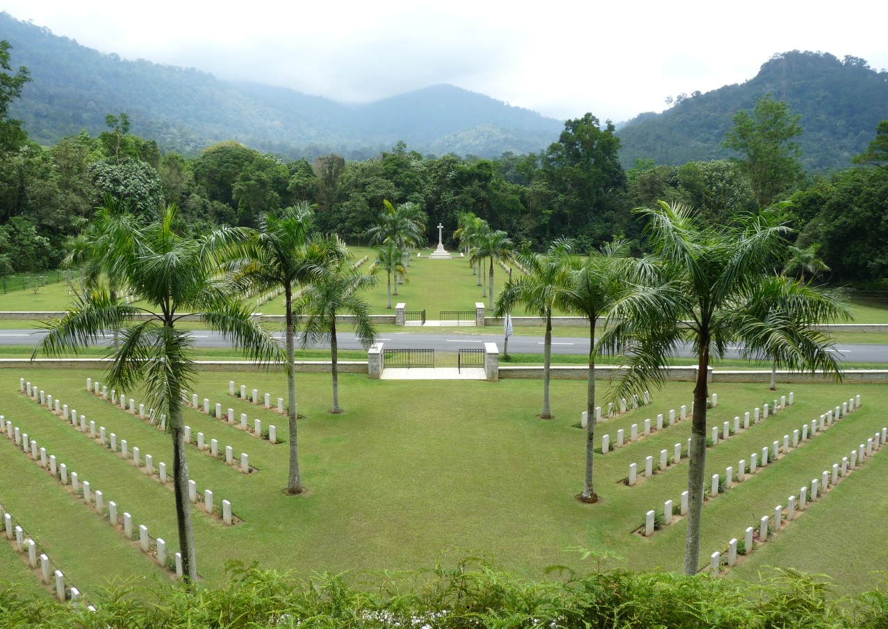
A Road Between Two Faiths
Jalan Bukit Larut, the road that climbs toward the hill station above Taiping, passes directly through the cemetery and divides it in two. On the southeastern side lie the Christian graves, marked by a Cross of Sacrifice on the boundary. On the northwestern side lie the non-Christian graves, anchored by a Stone of Remembrance. Muslim headstones are aligned to face Mecca, as their faith requires. The division reflects the diversity of the forces that fought in Malaya -- British, Indian, Australian, Malay -- and the care the Commonwealth War Graves Commission takes to honor the dead according to their own traditions. Where regimental insignia could be identified, they are carved into the white granite. Where nothing was known, the stone speaks for itself.
Squadron Leader Scarf's Last Flight
Among the identified graves, one stands apart. Squadron Leader Arthur Stewart King Scarf of the Royal Air Force was one of the first British airmen killed in Malaya. On 9 December 1941 -- just one day after the Japanese invasion began -- Scarf led a bombing mission against the Japanese at Singora in southern Thailand. His squadron was devastated by enemy fighters, and Scarf was severely wounded during the attack, but he managed to fly his damaged aircraft back across the border and crash-land at Alor Star. He died of his wounds shortly afterward, at the age of 28. His Victoria Cross, awarded posthumously, was one of the first of the war in the Pacific theater. He rests now in Taiping, his headstone bearing the regiment's insignia and the letters "VC" -- a distinction shared by relatively few of the thousands who lie in Commonwealth cemeteries around the world.
From the Air
Located at 4.859N, 100.758E on the lower slopes of Bukit Larut, Taiping, Perak, Malaysia. The cemetery is adjacent to Jalan Bukit Larut, the road climbing toward Maxwell Hill. Sultan Azlan Shah Airport (WMBA) in Ipoh is approximately 60 km southeast. Penang International Airport (WMKP) is roughly 90 km northwest. From the air, look for the orderly rectangular layout with white headstones visible against manicured green lawns, divided by the road. Best viewed at 2,000-4,000 feet. The Titiwangsa Range rises sharply to the east.