Takata-matsubara
Seventy thousand pine trees stood along two kilometers of beach at Rikuzentakata. On the afternoon of March 11, 2011, every single one was ripped from the earth by a ten-meter tsunami, except one. That solitary survivor, a 27-meter pine roughly 170 years old, became the most photographed tree in Japan overnight, a living symbol of hope rising from a field of absolute destruction. The Japanese called it the Miracle Pine.
A Merchant's Living Wall
The Takata Matsubara began as a practical act of engineering dressed in green. In 1667, a wealthy local merchant named Kanno Mokunosuke planted 6,200 Japanese red pine trees along the shore under instructions from Date Tsunamune, the daimyo of Sendai Domain. The purpose was blunt: create a living seawall to shield the port village from high winds, storm surges, and tsunami. Two generations later, Mokunosuke's son Shichizaemon and grandson Hachisaburo expanded the grove dramatically during the Kyoho period of 1716 to 1736, adding 70,000 more trees in a mix of Japanese red pine and Japanese black pine. What began as coastal defense became something grander. The forest stretched for two kilometers along the beach, a thick green curtain between the village and the Pacific, and over the centuries it grew into one of the most celebrated landscapes in Japan.
Three Centuries of Standing Guard
The pines earned their keep. When the 1896 Sanriku earthquake sent a tsunami crashing into the coast, the Takata Matsubara absorbed the blow and protected the settlement behind it. The grove held again during the 1933 Sanriku earthquake and once more against waves generated by the 1960 Valdivia earthquake in Chile, which traveled across the entire Pacific to strike this shore. By 1940, the forest had been designated a nationally recognized Place of Scenic Beauty. In 1964, it became part of the Rikuchu Kaigan National Park, drawing thousands of visitors who came to walk beneath the canopy and look out across the sand to the sea. The pine forest was simultaneously infrastructure and icon, a working seawall that happened to be beautiful.
Ten Meters of Black Water
The tsunami that followed the magnitude 9.0 Tohoku earthquake on March 11, 2011, was unlike anything the Takata Matsubara had faced in its 344-year history. The wave exceeded ten meters in height at this stretch of coast, dwarfing the pines that had turned back every previous assault. Within minutes, the forest was gone. Tens of thousands of trees were snapped, uprooted, and carried inland in a churning wall of water and debris. The city of Rikuzentakata behind the grove was devastated. When the water finally receded, the two-kilometer beach was buried under meters of silt, and the landscape was unrecognizable. Except for one tree. A single pine, roughly 170 years old and standing 27 meters tall, remained upright in the wreckage, battered but alive.
The Miracle and the Monument
The image of that lone pine standing against a gray sky became a national sensation. Newspapers worldwide carried the photograph. The tree was dubbed the Miracle Pine, and for a traumatized nation it embodied something desperately needed: the idea that survival was possible against impossible odds. Because one tree still stood, Japan's official designation of Takata Matsubara as a Place of Scenic Beauty was technically not revoked. But the miracle had limits. By December 2012, seawater contamination in the surrounding soil killed the tree. Rather than let it disappear, the city of Rikuzentakata launched a preservation project costing 150 million yen. The trunk was dismantled, hollowed out, treated against decay, and fitted with a carbon fiber spine. The branches, too damaged to save, were replaced with carefully modeled replicas. The reconstructed Miracle Pine was reinstalled as the centerpiece of the Takata Matsubara Memorial Park, a monument to both loss and persistence.
Seeds in the Sand
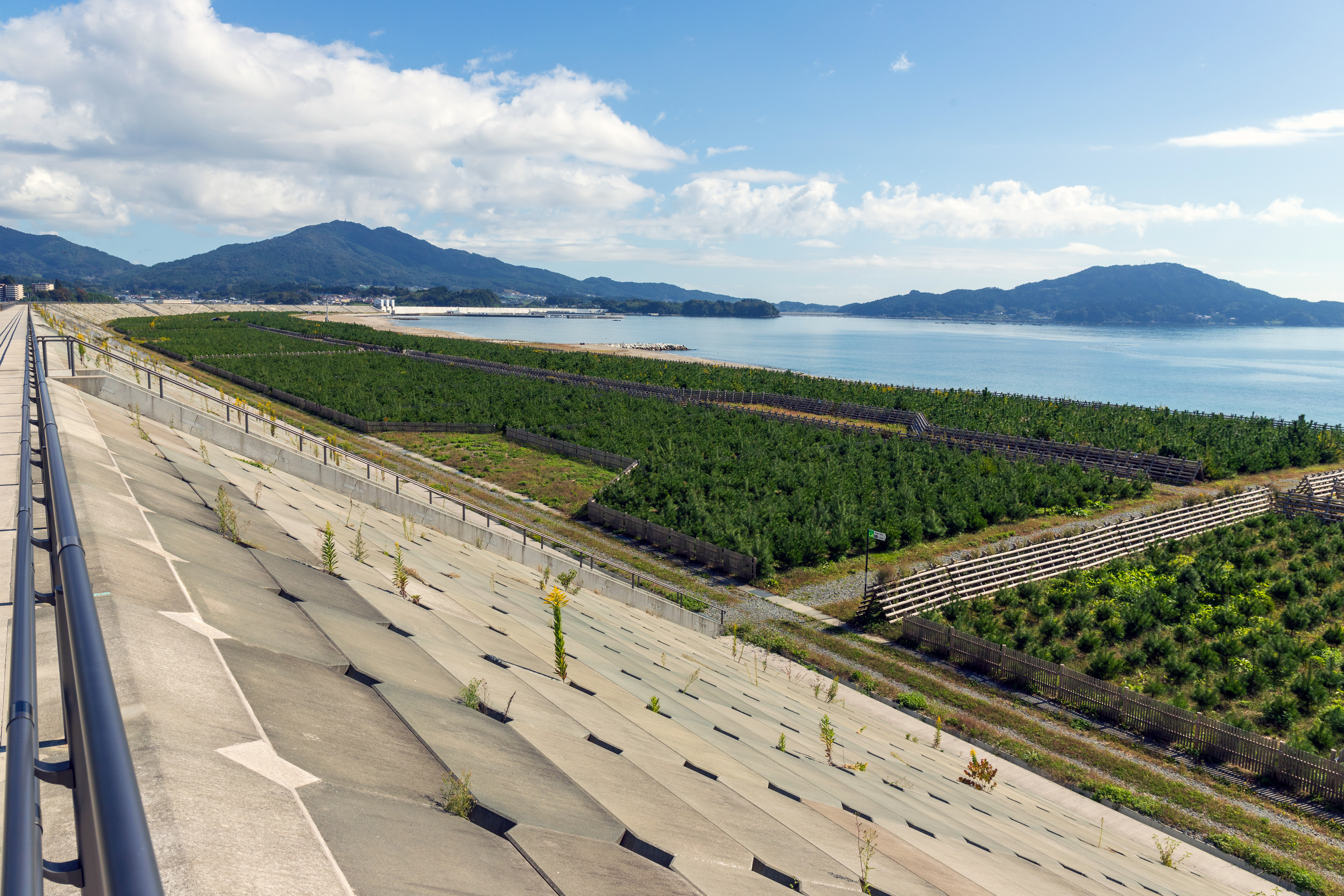
Recovery at Takata Matsubara has been slow and deliberate. A massive new seawall was constructed beginning in December 2013, and years of work went into clearing the silt that had buried the beach. Cleanup was complicated by fears that wood from the fallen pines had been contaminated by radiation from the Fukushima Daiichi nuclear disaster. In 2017 and 2018, volunteer tree-planting events brought 2,500 pine seedlings into the ground along the restored shoreline. The area is now part of the Sanriku Fukko National Park, a new park created specifically to support recovery and commemoration along the tsunami-affected coast. The seedlings are still small. It will take decades, perhaps a century, before anything resembling the original forest stands here again. But the planting continues, just as it did when Kanno Mokunosuke put the first red pines into the sand more than 350 years ago.
From the Air
Takata Matsubara is located at 39.00N, 141.63E along the Pacific coast of Iwate Prefecture, on the shoreline of Rikuzentakata. From the air, look for the broad crescent beach at the head of Hirota Bay, with the reconstructed seawall and the memorial park visible along the waterfront. The Miracle Pine monument stands as a solitary vertical element near the beach. The nearest airport is Hanamaki Airport (RJSI), approximately 90 km inland to the west. The Sanriku Coast here features dramatic rias topography with deep bays cutting into forested hills. Recommended viewing altitude: 2,000-4,000 feet to see the contrast between the beach, memorial park, and the new seedling plantings.