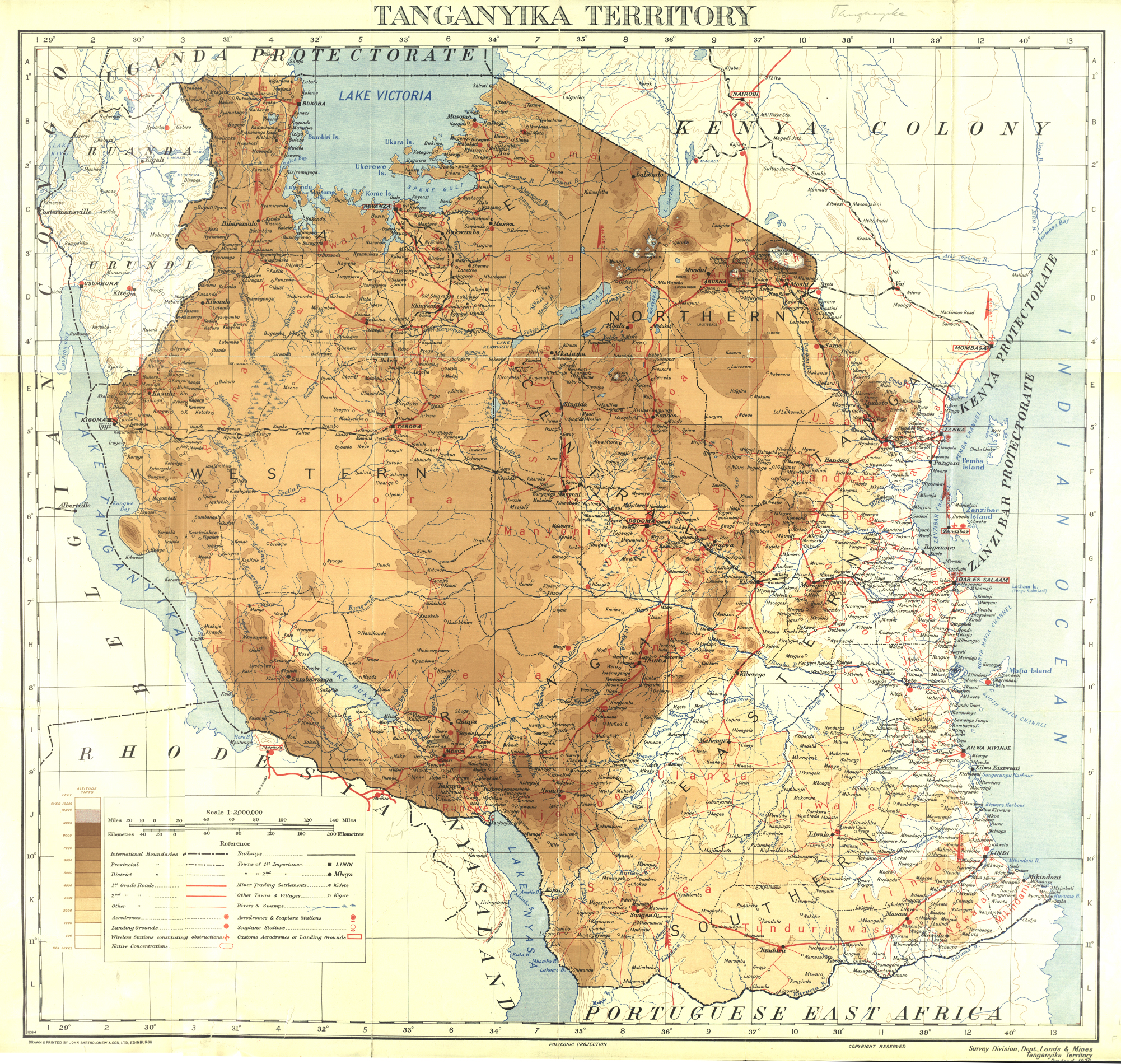
Tanganyika Territory
Before it was called Tanganyika, it nearly became "Smutsland." When the British took control of German East Africa after World War I, officials debated what to rename the vast territory stretching from the Indian Ocean to the Great Lakes. Suggestions included "New Maryland," "Windsorland," and "Eburnea" -- all rejected. "Kilimanjaro" was considered, borrowing the Kenya model of naming a country after its tallest mountain. A junior colonial official finally pointed out that under a League of Nations mandate, "Territory" was more appropriate than "Protectorate," and so the land took the name of the great lake on its western border -- a name that explorer Henry Morton Stanley had recorded in 1876, noting that locals translated it roughly as "the great lake spreading out like a plain."
Caravans, Sultans, and the Scramble
Long before European powers divided East Africa on maps, Omani and Arab traders had woven the coast into a web of commerce that stretched deep into the continental interior. When Seyyid Said took power in Oman in 1806, Zanzibar became the western Indian Ocean's commercial fulcrum, and the mainland opposite it -- the territory that would become Tanganyika -- served as both source and corridor. Trade caravans carried ivory and enslaved people from the Great Lakes region to the coast, connecting hundreds of communities along routes that also spread Islam among peoples like the Yao in the south. In 1885, Carl Peters declared a German protectorate over the area. When the Sultan of Zanzibar objected, German warships threatened to bombard his palace. He acquiesced. The Germans brutally suppressed the Maji Maji Rebellion of 1905, then set about building railways and cultivating cash crops -- sisal above all. By 1913, the colony exported over 20,000 tons of sisal, accounting for 30 percent of its total exports, shipped out through Dar es Salaam along the Mittellandbahn, a central railway line still in use today.
From German Colony to British Mandate
World War I ended German rule. British and Belgian forces gradually occupied the territory during the East Africa Campaign, though German resistance under General Paul von Lettow-Vorbeck held out until 1918. The Treaty of Versailles carved the colony apart: Ruanda-Urundi went to Belgium, the tiny Kionga Triangle to Portuguese Mozambique, and the rest became British Tanganyika. The new administrators pursued what they called a "Black man's country" policy, modeled loosely on Nigeria's system of indirect rule. But the transition was hardly smooth. Sir Horace Bryatt, the territory's first civilian administrator, expelled so many German settlers that the European population halved. Former German plantations were sold to European companies; British owners took over mixed farms. The economy remained tethered to cash crops, especially coffee. Meanwhile, the Asian community grew under British protection -- from 8,698 people in 1912 to 25,144 by 1931 -- many recruited from British India to staff the colonial administration.
The Teacher Who Won Every Seat
Julius Nyerere was a schoolteacher before he became a revolutionary, and his revolution was remarkably quiet. The Tanganyika African National Union, which he led, did not seize power through armed struggle. It won elections. In the 1958 colonial elections, TANU candidates or TANU-backed candidates took every available seat -- a result that astonished British administrators and left little room for argument. TANU's message resonated because it spoke to a genuine fear: that even after independence, European and Asian minorities would retain disproportionate power. Two-thirds of the 28,500 registered voters were African, and they voted in overwhelming unity. Fresh elections in 1960 confirmed the mandate. On 9 December 1961, Tanganyika became independent, one of the most peaceful transfers of power in African colonial history. Nyerere won the presidential election the following year. At its peak, the territory had also been the world's largest producer of beeswax -- a detail that hints at the richness of the land European powers had fought to control.
A Young Nation's Crossroads
Independence brought freedom but not stability. Tanganyika shared borders with the Congo, Burundi, and Rwanda -- all embroiled in their own post-colonial crises -- and refugees poured across the frontiers into a country with almost no infrastructure to absorb them. Nyerere's answer was Ujamaa, an African socialist philosophy that called for collective farming and national self-reliance. The ideology was idealistic; its implementation displaced many rural farmers whose livelihoods were disrupted by state-directed agricultural consolidation. Then came the event that created modern Tanzania. In 1964, the Zanzibar Revolution overthrew the island's Arab sultanate in a violent upheaval. Within months, Tanganyika and Zanzibar merged to form the United Republic of Tanganyika and Zanzibar -- renamed the United Republic of Tanzania on 29 October 1964. The name Tanganyika faded from political maps, but it endures in the lake, in the railway, and in the memory of a territory that changed hands three times in less than fifty years.
From the Air
Centered on Dar es Salaam at approximately 6.80S, 39.28E. From cruising altitude, the coastline of the former territory stretches hundreds of kilometres along the Indian Ocean. The Mittellandbahn railway corridor runs west from Dar es Salaam toward Lake Tanganyika. Nearest major airport is Julius Nyerere International Airport (HTDA) in Dar es Salaam. Kilimanjaro International Airport (HTKJ) lies to the north near Arusha. The Wami River delta and Zanzibar Channel are visible features from altitude.