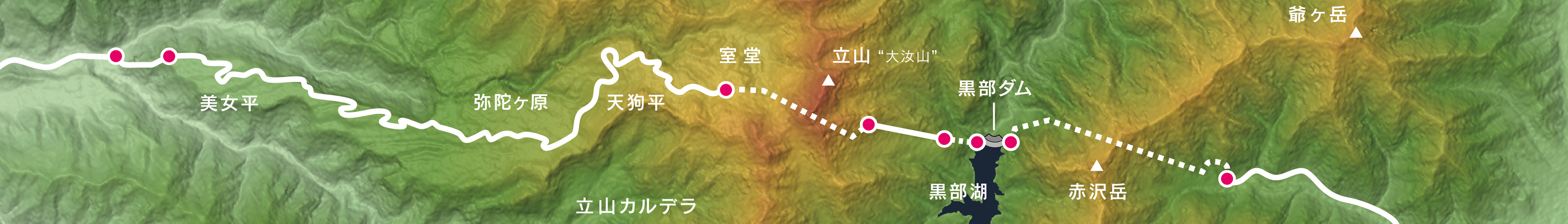
Tateyama Kurobe Alpine Route
Every April, snowplows carve a narrow corridor through drifts that can tower 20 meters above the roadbed, and for a few weeks tourists walk between walls of packed snow taller than a six-story building. This is Yukino-otani, the most photographed stretch of the Tateyama Kurobe Alpine Route -- but the snow walls are just the opening act. The full route spans 37 kilometers across the Hida Mountains from Tateyama in Toyama Prefecture to Omachi in Nagano Prefecture, climbing nearly 2,000 meters in elevation through a chain of cable cars, tunnel buses, aerial tramways, and one of the last trolleybus lines in Japan. Opened on June 1, 1971, the route was stitched together from infrastructure originally built for one of the most ambitious engineering projects of the 20th century: the construction of Kurobe Dam.
The Construction Project of the Century
Kurobe Dam stands 186 meters tall, making it the highest dam in Japan, and its construction between 1956 and 1963 was an undertaking so vast it became known as the "Construction Project of the Century." Ten million workers labored over those seven years, and 171 died in the process -- their names inscribed on a memorial at the dam site. The most harrowing chapter was the excavation of what is now the Kanden Tunnel through the mountains. Workers hit a massive fracture zone in the rock that halted progress for seven months as water and debris poured into the bore. The section of the Alpine Route between Kurobe Dam and Ogisawa exists because those tunnels were carved for dam construction. The road was already there; someone just had to open it to tourists.
Seven Vehicles, One Crossing
No single machine can cross the Japanese Alps. The Tateyama Kurobe Alpine Route requires seven different transportation services using five distinct modes: funicular railway, highway bus, trolleybus, aerial tramway, and walking. Three of the transport lines run through tunnels, shielded from the crushing snowfall that buries the mountains each winter. The Tateyama Tunnel Trolleybus is the last trolleybus line still operating in Japan -- its parallel, the Kanden Tunnel line, converted to battery-electric buses in 2018, leaving the Tateyama route as the sole survivor of a once-common technology, chosen because electric motors produce no exhaust fumes in the confined tunnel air. The Tateyama Ropeway, which carries passengers from Daikanbo to Kurobedaira, has no support towers along its span, hanging free over a valley where, on clear days, Mount Fuji is visible on the eastern horizon.
Walking Through Winter's Architecture
The snow walls of Yukino-otani are not sculpted or constructed. They are simply what remains when plows clear the road to Murodo Station each spring. The Tateyama Mountains receive some of the heaviest snowfall on Earth, and by winter's end, drifts along the route to Murodo can reach 20 meters -- the record height, set in the year 2000. The 500-meter walking corridor flanking the road opens from mid-April to June, and visitors from across East Asia -- charter flights arrive from Taipei, Incheon, and Thailand during peak season -- come to walk between these towering white cliffs. The snow is dense and layered, each stratum recording a different storm. By June the walls have begun to sag and drip, and by summer they are gone, replaced by the green marshlands of Midagahara, a plateau of flowing grasses and blue ponds that looks nothing like the frozen canyon it was three months earlier.
Sulfur and Shrines at the Roof of the Route
Murodo Plateau, at 2,450 meters, is the highest point on the Alpine Route and a world apart from the valley floor. The Oyama Shrine sits near the summit, a reminder that Mount Tate is one of Japan's three sacred mountains. Nearby, Hell's Valley -- Jigokudani -- vents sulfurous gas from volcanic fumaroles, the acrid smell mixing with the cold alpine air. Visitors cannot enter the valley itself due to gas concentrations, but the hiking paths that ring its edge offer views of the barren, mineral-stained landscape. There is also an onsen on the plateau, fed by sulfur spring water, where hikers soak after a day on the trails. The contrast is pure Japan: sacred shrines, volcanic danger, and hot baths, all within walking distance of each other at the top of an engineering marvel.
From the Air
The Tateyama Kurobe Alpine Route runs roughly east-west through the Hida Mountains (Northern Japanese Alps), centered near 36.57N, 137.53E. Kurobe Dam is visible as a distinctive arc-shaped structure in a deep gorge. The Yukino-otani snow walls are along the road approaching Murodo Station at approximately 2,450 meters elevation. Terrain rises to 3,015 meters (Mount Tate / Tateyama). Maintain significant altitude clearance -- minimum 12,000 feet MSL recommended for overflight. The aerial tramway cables between Daikanbo and Kurobedaira are a wire-strike hazard at low altitude. Nearest airport: Toyama Airport (RJNT), approximately 25nm east. Also accessible from Matsumoto Airport (RJAF) on the Nagano side. Expect mountain wave turbulence, rapid weather changes, and orographic cloud formation year-round.