Tatoosh Island
Half a mile off Cape Flattery, where the Strait of Juan de Fuca surrenders to the open Pacific, a cluster of rocky islands rises from the swells. The largest is Tatoosh, named for a Makah chief also known as Tatooche or Tetacus, and it carries more history and scientific importance than its 40 acres would suggest. No one lives here now. The seasonal Makah fishing camps are gone, the Coast Guard and Weather Bureau personnel departed long ago. What remains is a lighthouse that has warned mariners since 1857, an entire island listed on the National Register of Historic Places, and one of the most studied marine ecosystems on the Pacific Coast.
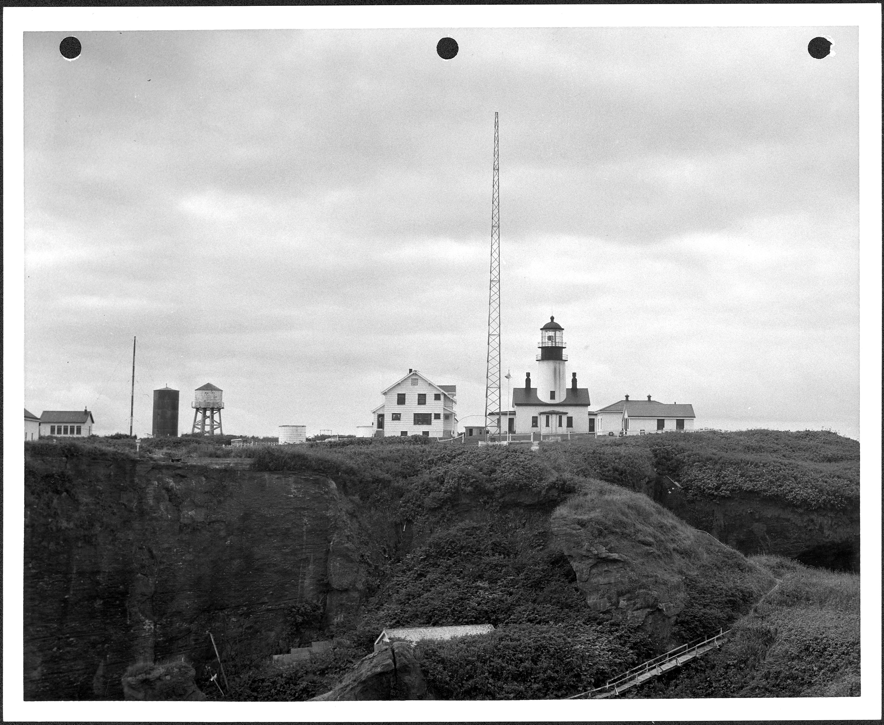
The Light at the Edge
Cape Flattery Light began operating on December 28, 1857, its beam sweeping across the entrance to the Strait of Juan de Fuca. For mariners rounding the Olympic Peninsula, this was the signal that they had reached the gateway to Puget Sound or were about to leave it for open ocean. The lighthouse served for over a century alongside weather observers, Coast Guard personnel, and Navy staff who rotated through the island's small complement of buildings. A weather station on Tatoosh recorded climate data until 1966, contributing decades of meteorological records for this notoriously unpredictable stretch of coast. The entire island was placed on the National Register of Historic Places in 1972, recognizing both the lighthouse and the broader cultural landscape shaped by the Makah people who used these islands for centuries before any lighthouse keeper arrived.
Where Keystone Species Were Defined
In 1967, Professor Robert T. Paine of the University of Washington began studying the marine life clinging to Tatoosh's intertidal rocks. What he and his colleagues discovered here reshaped the field of ecology. Paine's work on Tatoosh helped establish the concept of the keystone species, the idea that certain organisms exert an outsized influence on their ecosystem relative to their abundance. His research revealed how species are linked through intricate webs of interaction, and how the removal of a single predator can cascade through an entire community. In 1990, Julia Parrish joined the island's research effort and launched a long-term study of seabirds that continues to generate insights into population dynamics, ocean acidification, and the ecological ripple effects of El Nino events. Tatoosh became, and remains, a place where the complexity of marine ecosystems is laid bare.
Scotland on the Pacific
Tatoosh's climate has more in common with northern Scotland or Haida Gwaii than with the rest of Washington state. Fully exposed to maritime winds from every direction, the island experiences extremely moderated temperatures year-round. Summers are cool and long but never warm. Winters are mild and relentlessly wet. The dry-summer pattern that defines most of the Pacific Northwest simply does not exist here; rain falls abundantly in every season. This exposure places Tatoosh in USDA hardiness zone 9b, warmer than most of western Washington despite being farther north, because the surrounding ocean buffers against temperature extremes. It is a climate shaped entirely by water and wind, with no mountains or forests to interrupt either.
Makah Ground, Closed to Visitors
Tatoosh Island belongs to the Makah Reservation, and accessing it requires written permission from the tribe. This is not a place you visit casually. The Makah used these islands as seasonal fishing camps, a practice that predates written records by millennia. The islands sit almost as far west as Cape Alava, about 15 miles to the south, which holds the distinction of being the westernmost point in the contiguous 48 states. Together, Tatoosh and Cape Flattery define the extreme northwest corner of the lower United States, a geographic fact that makes the isolation feel intentional, as if the land itself is drawing a boundary. For seabirds and marine mammals, that isolation is an asset. Nesting colonies thrive here precisely because humans stay away.
From the Air
Located at 48.39N, 124.74W, approximately 0.5 miles northwest of Cape Flattery. Visible as a small rocky island group off the tip of the Olympic Peninsula. Nearest airport is William R. Fairchild International Airport (KCLM) in Port Angeles, about 75 miles east. Best viewed at 1,500-2,500 ft AGL. The Cape Flattery Light is the primary visual landmark. The island marks the entrance to the Strait of Juan de Fuca.