Taupō Volcanic Zone
Fifty kilometres beneath the surface, a film of magma stretches 160 kilometres long and 50 kilometres wide. Above it, the Earth's crust thins to as little as 16 kilometres - a geological membrane separating the pastoral farmland and tourist towns of New Zealand's North Island from one of the most volcanically productive zones on Earth. The Taupō Volcanic Zone has been tearing itself apart for two million years, and it shows no signs of stopping.
A Rift Running Hot
The zone stretches 350 kilometres from the snow-capped summit of Mount Ruapehu in the southwest to the steaming waters around Whakaari / White Island in the Bay of Plenty. It traces the path of the Taupō Rift, where the Pacific and Australian tectonic plates collide and the resulting back-arc extension pulls the land apart. At the Bay of Plenty coast the rift widens fastest; at Ruapehu, barely at all. In between lies Lake Taupō itself - not a lake formed by rivers or glaciers, but the flooded caldera of the zone's most powerful volcano, filled with water so deep and blue that it could pass for a natural wonder of a gentler origin.
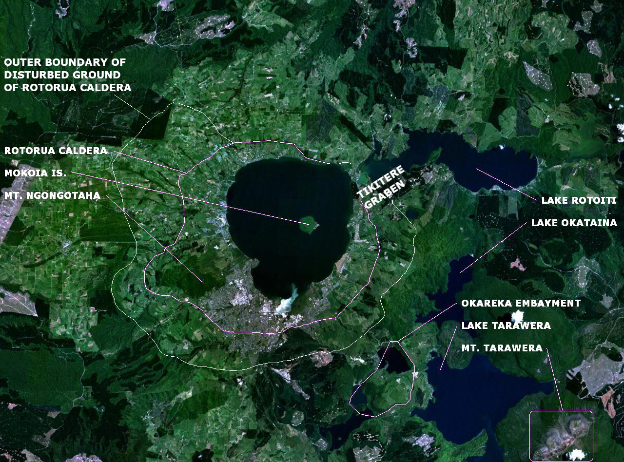
The Caldera Factory
Over the past 350,000 years, the central zone has produced more than 3,900 cubic kilometres of volcanic material from over 300 silicic eruptions - more than any comparable region on Earth. Twelve of those eruptions were violent enough to collapse entire volcanoes into calderas. The Oruanui eruption roughly 26,500 years ago expelled an estimated 1,170 cubic kilometres of material, making it one of the largest eruptions in the geological record. The rhyolite magma responsible for these cataclysms is gaseous, viscous, and rich in silicon - a chemistry that produces not gentle lava flows but explosive blasts that laid down the ignimbrite sheets forming the North Island's volcanic plateau. Eight caldera centres line the central zone, from the ancient Mangakino caldera, active over a million years ago, to the still-restless Taupō and Ōkataina systems.
Where the Ground Still Breathes
The zone's geothermal energy is unmistakable. Whakaari / White Island has been in near-continuous volcanic activity since 1826, its submarine bulk dwarfing the visible summit crater. Mount Ngāuruhoe, the steep-sided cone that stands as Ruapehu's younger sibling, erupted regularly through the twentieth century. Below the surface, geothermal fields power steam vents, boiling mud pools, and hot springs from Rotorua to Taupō. The Wairakei geothermal system north of Taupō became one of the world's first to be harnessed for electricity generation. Visitors to the region walk boardwalks over hissing fumaroles, the sulphur smell sharp in the air, while the ground shifts underfoot on geological timescales - and sometimes on human ones.
Living on the Edge
The most recent large eruption in the zone was Mount Tarawera's devastating blast in 1886, which killed around 120 people and obliterated the famed Pink and White Terraces. But the geological record warns of far worse. The Taupō eruption of 232 CE was one of the most violent eruptions anywhere in the past 5,000 years, sending pyroclastic flows racing across the landscape at hundreds of kilometres per hour. Today, nearly 500,000 people live within the volcanic zone. Rotorua thrives as a tourist destination built on its geothermal oddities. Taupō town wraps around the shore of its namesake caldera lake. The volcanoes that created the landscape people love are the same ones that could remake it in an afternoon.
From the Air
The Taupō Volcanic Zone runs roughly SW-NE from Mount Ruapehu (39.28°S, 175.57°E) through Lake Taupō (38.82°S, 176.00°E) and Rotorua (38.14°S, 176.25°E) to White Island (37.52°S, 177.18°E) in the Bay of Plenty. At cruising altitude, the zone is visible as a corridor of calderas, lakes, and volcanic cones running through the North Island's center. Lake Taupō - the flooded caldera - is the dominant landmark. Nearest major airports: NZRO (Rotorua), NZAP (Taupō), NZWN (Wellington). Watch for steam plumes from geothermal areas in calm conditions.