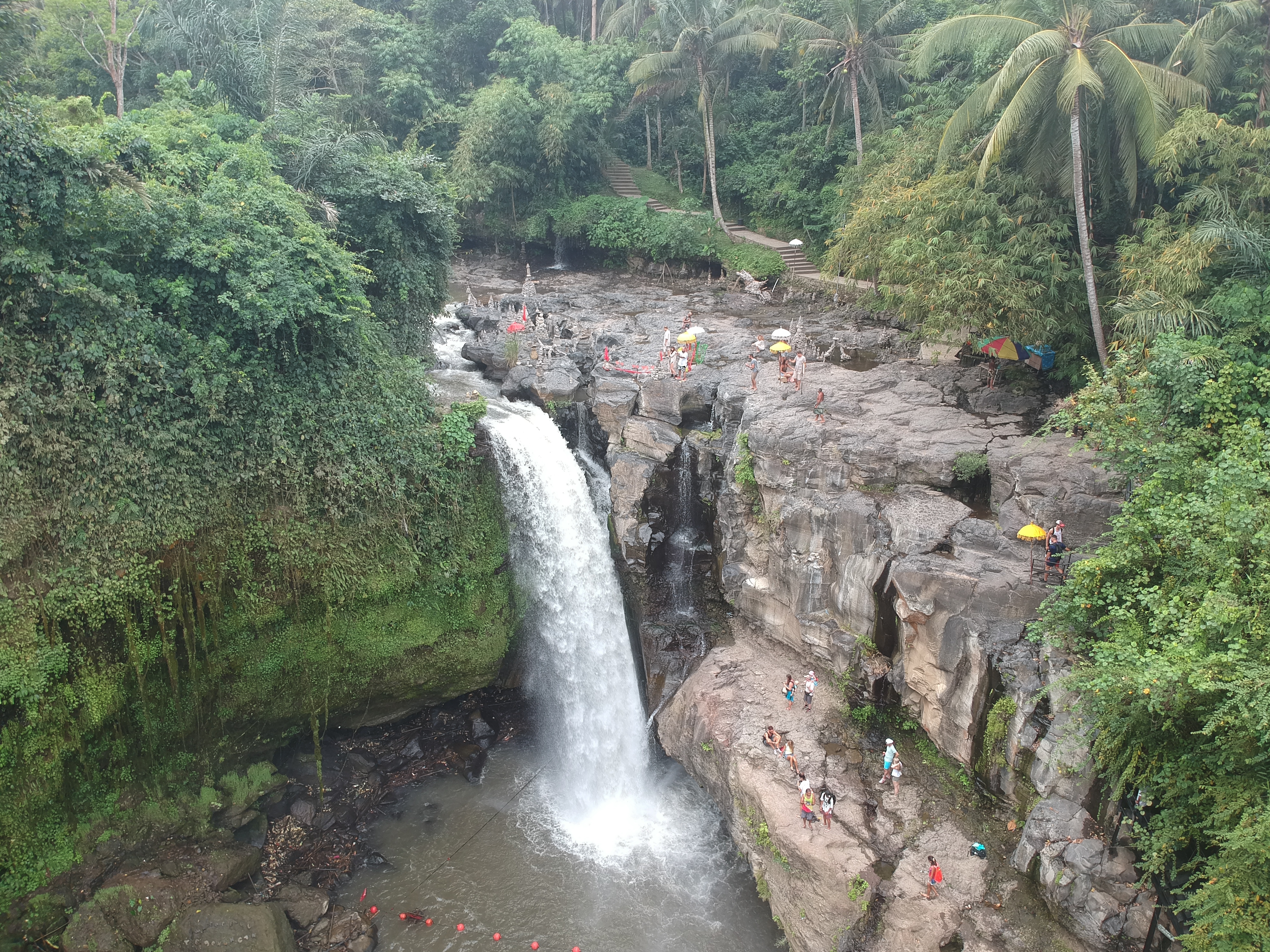
Where the Sacred River Falls
Most of Bali's waterfalls hide in the volcanic highlands, requiring hours of mountain roads to reach. Tegenungan is different. Barely thirty minutes north of the capital Denpasar, just south of the artist village of Ubud, the Petanu River drops roughly fifteen to twenty meters into a jungle-framed pool that feels impossibly remote for its proximity to civilization. The descent is a concrete staircase cut into the ravine wall, and the climb back up will remind you of every step -- but the reward at the bottom is a curtain of water thundering into a basin wide enough to swim in, flanked by walls of green so dense they muffle the sound of the motorbikes on the road above.
Born on a Volcano's Slopes
The water that crashes over Tegenungan's lip has traveled a long way. The Petanu River originates in the highlands of Mount Batur in Kintamani, one of Bali's active volcanoes, and flows approximately 47 kilometers through some of the island's most culturally significant landscape. It passes through Tampaksiring, where ancient rock-cut shrines line its banks, then through Ubud before reaching the village of Tegenungan Kemenuh in the Gianyar Regency. The Petanu ranks among Bali's longest rivers, after the Ayung and Telaga Waja, and its watershed feeds the rice terraces that have sustained Balinese agriculture for centuries. By the time it reaches this particular cliff edge, the river has gathered the runoff of an entire volcanic slope.
Holy Water, Living Prayers
To the people of Kemenuh village, the Petanu is not merely a river. In Balinese Hindu tradition, flowing water carries spiritual power -- the capacity to purify, to sustain, to connect the human world to the divine. The local community regards the Petanu as a source of both physical sustenance and spiritual protection, and the area around the waterfall has long served as a place for meditation and prayer. Ceremonies and rituals are still performed here, woven into the rhythms of the Balinese calendar. This dual identity -- sacred site and swimming hole, place of worship and tourist attraction -- is not the contradiction it might seem. Balinese Hinduism has always understood the sacred and the everyday as inseparable. The water that blesses a temple offering is the same water that irrigates a rice paddy. Tegenungan holds both roles without strain.
Two Seasons, Two Waterfalls
Visiting Tegenungan during the dry season, from April to October, and visiting during the wet season are almost like seeing two different places. In the dry months, the water runs clearer and the flow narrows to an elegant cascade, the pool below calm enough for comfortable swimming. The stone steps down to the base are dry and manageable, the light filters through the canopy in clean shafts, and photographers find the conditions ideal. Come back between November and March and the Petanu swells with monsoon rains, transforming the falls into a roaring wall of brown-white water that shakes the ground. The paths grow slippery and the pool churns too violently for swimming, but the sheer force of the spectacle -- mist rising into the canopy, the sound reverberating off the ravine walls -- makes the wet season the more dramatic experience by far.
A Lowland Exception
What makes Tegenungan unusual among Bali's waterfalls is its elevation -- or lack of it. The island's volcanic spine, anchored by Mount Agung at 3,031 meters, produces dozens of waterfalls in its highland valleys, most of them requiring winding drives through mountain villages to reach. Tegenungan sits in the lowlands of the Gianyar Regency, making it one of the most accessible falls on the island. A viewing platform at the main entrance offers a panoramic look down into the ravine and across the surrounding jungle canopy before you commit to the descent. The waterfall includes varying tiers that can be climbed by the adventurous, and the surrounding cliffs provide natural vantage points where the mist from the falls keeps the air cool even at midday. It is not the tallest or the most remote waterfall in Bali. It is the one you can reach before lunch and still feel like you have left the world behind.
From the Air
Located at 8.575°S, 115.291°E in the Gianyar Regency lowlands, south of Ubud. The waterfall ravine is not visible from cruise altitude but the Petanu River valley can be traced as a green corridor through the surrounding development. Ngurah Rai International Airport (WADD) lies approximately 15 nm to the southwest. The lush green canopy cover along the river stands out against the drier agricultural land on either side.