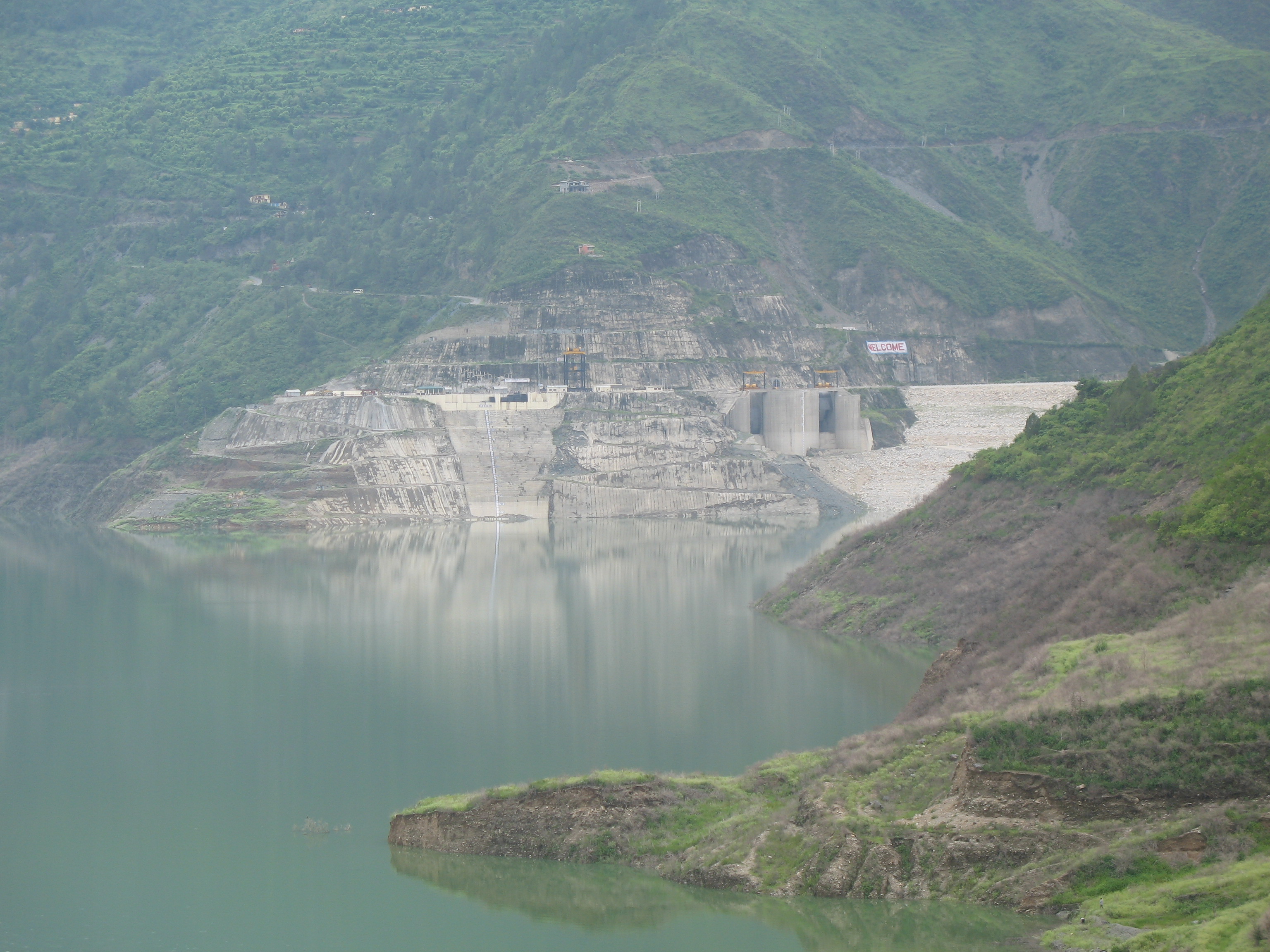
Tehri Dam
Somewhere beneath 52 square kilometers of turquoise reservoir water lies Old Tehri, a hill town that existed for centuries at the confluence of the Bhagirathi and Bhilangna rivers in the Garhwal Himalayas. The town's temples, bazaars, and homes vanished when the reservoir filled in 2005, replaced by a lake so vast it transformed the mountain landscape visible from the air. Rising 260.5 meters above its foundation, the Tehri Dam is the tallest in India and among the tallest on Earth - a wall of rock and earth holding back the headwaters of what Hindus consider the holiest river in the world.
Decades in the Making
The idea for harnessing the Bhagirathi first took shape in 1961, when preliminary investigations were completed under Jawaharlal Nehru's government. The design was finalized in 1972, envisioning a 600 MW power plant. Construction began in 1978, but the project immediately became entangled in delays - financial shortfalls, environmental objections, and the wrenching displacement of tens of thousands of people from the valley. In 1986, the Soviet Union stepped in with technical and financial support, only to withdraw as the USSR itself began to fracture. India took sole control, creating the Tehri Hydro Development Corporation in 1988, with the federal government shouldering 75 percent of the costs and Uttar Pradesh covering the rest. What was initially planned as a straightforward dam project stretched across nearly three decades before the structure was finally completed in 2006.
An Engineering Colossus
The numbers are staggering. The dam's crest stretches 575 meters across the valley, 20 meters wide at the top and flaring to an enormous 1,128 meters at the base. Its reservoir holds 3.54 cubic kilometers of water. Four generators produce 1,000 MW of hydroelectricity, and an additional 1,000 MW pumped-storage facility uses the downstream Koteshwar Dam as its lower reservoir - a system whose variable-speed turbines can adjust to fluctuating water levels with unusual efficiency. Together with the 400 MW Koteshwar Dam, the Tehri Hydropower Complex distributes electricity across nine states and territories, from Rajasthan to Jammu and Kashmir. It irrigates 270,000 hectares of farmland, stabilizes irrigation across 600,000 more, and supplies drinking water to Delhi, Uttar Pradesh, and Uttarakhand. The total cost reached one billion US dollars, and the complex generates roughly 3,000 gigawatt-hours annually.
Sacred Waters, Bitter Protest
For millions of Hindus, the Bhagirathi is not merely a river. It is one of the source tributaries of the Ganges, believed to have descended from heaven through Lord Shiva's matted hair. When the reservoir began filling in 2005, the river's flow below the dam plummeted from roughly 1,000 cubic feet per second to a mere 200 - and at certain times of year, the Bhagirathi ceased flowing altogether. The environmental activist Sunderlal Bahuguna, already famous for the Chipko tree-hugging movement, led the Anti-Tehri Dam campaign from the 1980s until 2004, arguing that the dam threatened both the fragile Himalayan ecosystem and the spiritual lifeline of Hindu faith. Lawyer Virendra Dutt Saklani founded the Anti-Tehri Dam Struggle Committee, warning of consequences the planners had underestimated. Officials have maintained that once the reservoir reaches full capacity, normal river flow will resume. Many downstream communities remain unconvinced.
The Town That Disappeared
Old Tehri was not a village. It was the district headquarters, a town with courts, schools, and a centuries-old identity rooted in the Garhwal kingdom. Its residents were relocated to New Tehri, a planned settlement on a ridge above the reservoir. The transition was wrenching - families who had lived in the valley for generations found themselves in a place that lacked the old town's character and social fabric. Today, visitors to the reservoir's shore sometimes see remnants of Old Tehri emerge during dry seasons when the water level drops, ghostly foundations breaking the surface before the monsoon rains swallow them again. The reservoir itself has become a destination for water sports and tourism, a transformation that would have been unimaginable to the townspeople who once walked its streets.
Shaking Ground
The Tehri Dam sits in one of the most seismically active zones on Earth. The Himalayas are young mountains, still rising as the Indian tectonic plate grinds northward beneath the Eurasian plate. The region has experienced devastating earthquakes, and geologists have long debated whether a massive dam and heavy reservoir could increase seismic risk in the area. The Geological Survey of India conducted extensive appraisals, and the dam was engineered to withstand significant seismic events. Yet the concern persists, an unresolved tension between engineering confidence and geological uncertainty. In 2019, the Government of India approved NTPC Limited's takeover of the Tehri Hydro Development Corporation, consolidating oversight of this colossal structure under one of the country's largest power companies.
From the Air
Located at 30.378N, 78.481E in the Garhwal Himalayas of Uttarakhand, India. The dam and its vast turquoise reservoir are clearly visible from cruising altitude, set in a deep valley with Himalayan peaks in every direction. Nearest major airport is Jolly Grant Airport (VIDN) in Dehradun, approximately 90 km to the southwest. Recommended viewing altitude: 15,000-20,000 feet for full reservoir perspective. The dam wall itself is visible as a light-colored arc across the valley.