Tell Kunara
The mortar contains crushed bones. That detail, buried in an archaeological report about a 4,300-year-old building in the Zagros foothills, captures something essential about Tell Kunara: this was a place where people built with whatever the landscape and their ingenuity provided. Ten kilometers southwest of Sulaymaniyah in Iraqi Kurdistan, two oval mounds rise from the banks of the Tanjaro River -- one higher to the west, one lower to the east, split by a modern road that bisects what was once a single city. Excavators believe this ten-hectare site may have been the capital of the Lullubi, a mountain people who resisted the great Mesopotamian empires from the ridgeline of the Zagros.
A City Measured in Layers
Tell Kunara was first surveyed in 1943 by Sabri Shukri of the Iraqi General Directorate of Antiquities in Baghdad. The site lay largely undisturbed until Christine Kepinski conducted a broader survey in 2011, and a French National Center for Scientific Research team began systematic excavation the following year. Nine seasons of digging between 2012 and 2023 have revealed six periods of occupation stretching from the mid-third millennium BC through the medieval or early modern period. The densest habitation belongs to the late third millennium BC, when the site hosted monumental buildings with walls thick enough to support substantial structures. Radiocarbon dating places the earliest major construction phase between 2350 and 2200 BC, during the Akkadian period -- a time when Sargon of Akkad and his successors were forging the world's first empire to the south.
Bones, Bitumen, and Bronze
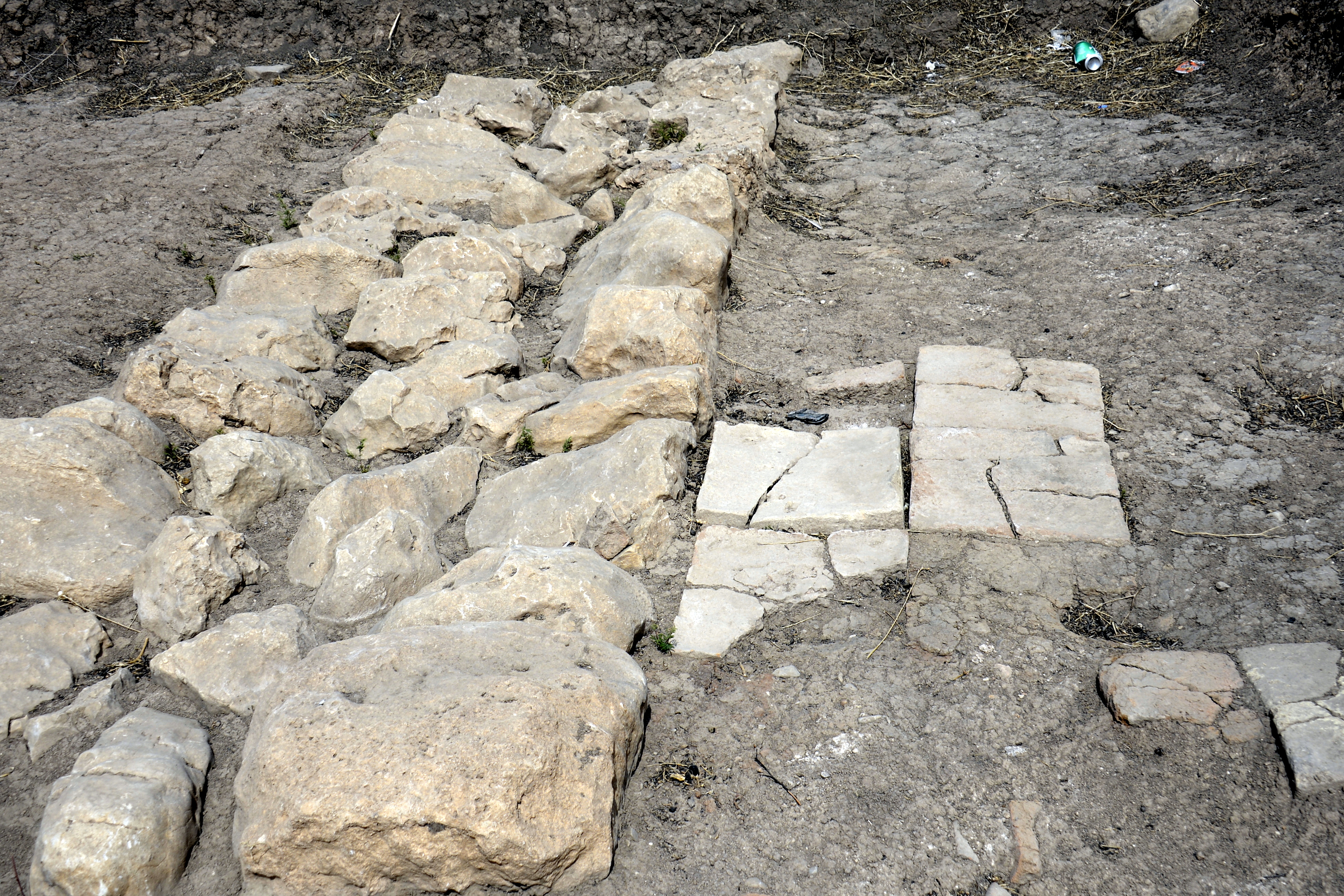
The Upper Town, designated Area A, contains a monumental building with walls 2.6 meters wide, built on massive stone foundations. The construction technique is striking: layers of rectangular mud bricks, sealed with diluted bitumen and jointed with mortar containing crushed bones, alternated with bands of pise -- rammed earth. A 100-square-meter courtyard fronted the building, drained by a ten-meter terracotta pipe. The Lower Town proved even more surprising. A geomagnetic survey had identified what appeared to be a single monumental structure measuring 60 by 30 meters. Excavation revealed not one building but four, joined together in an orthogonal layout connected by pebbled pathways. Small finds tell their own stories: bronze pins and beads, molds for casting bronze blades, a finely carved greenish Akkadian cylinder seal, an obsidian arrowhead.
The Tablets and the Missing Measure
Around 100 cuneiform tablets and fragments have been unearthed at Tell Kunara since 2015, most of them tiny -- roughly ten centimeters square. The majority record mundane transactions: flour deliveries, grain quantities. But mundane records carry revolutionary details. The tablets list volumes using a unit called the GUR of Subartu, a measurement system previously unknown to scholars. The expected standard would have been the Akkadian Empire's GUR, used across Mesopotamia. That Tell Kunara used its own system suggests a degree of administrative independence from the empire that nominally controlled the region. Epigraphic evidence confirms the city had an ensi -- a governor -- though who appointed him remains unknown. A sukkal, a high-level dignitary, was also present. This was not a village. It was a seat of power.
The Lullubi Question
The excavators have speculated that Tell Kunara, with its monumental architecture and administrative apparatus, was the capital of the Lullubi state. The Lullubi were a highland people known primarily from Mesopotamian sources that describe them as adversaries. The Victory Stele of Naram-Sin, one of the most famous works of ancient Near Eastern art, depicts the Akkadian king triumphing over the Lullubi in the Zagros Mountains. But the Lullubi perspective has been almost entirely absent from the record -- until now. Tell Kunara offers the possibility of hearing their side: their measurements, their building techniques, their administrative vocabulary. Whether the identification as the Lullubi capital holds or not, the site has already rewritten what was known about political organization in the Zagros foothills during the Bronze Age.
Digging in a Divided Landscape
A modern road cuts directly through the ancient city, separating the Upper and Lower Towns. Construction has damaged at least one monumental building in Area E. Across the site, evidence of habitation spans not just the Bronze Age but also the Iron Age and Islamic period, with pottery shards from as late as 1110 to 909 BC found at the surface in Area C. The site was occupied, abandoned, reoccupied, and built over for more than three thousand years. Today it sits in the Kurdistan Region of Iraq, a place where archaeological work has been both enabled and complicated by the region's political autonomy. French archaeologists continue their seasons here, reading the ground one careful layer at a time. The tablets wait in the Sulaymaniyah Museum, their small squares of baked clay holding the receipts of a civilization that measured the world on its own terms.
From the Air
Located at 35.52N, 45.36E, approximately 10 km southwest of Sulaymaniyah in the Kurdistan Region of Iraq. The site sits along the Tanjaro River in the Shahrizor Plain, at the foothills of the Zagros Mountains. Elevation approximately 700 meters. Nearest airport is Sulaymaniyah International Airport (ORSU), about 15 km to the northeast. The two oval mounds may be visible from lower altitudes as gentle rises in the agricultural landscape.