Tenampua
When American archaeologist Ephraim George Squier climbed to the summit of Tenampua in 1853, he was astonished twice -- once by the sheer scale of the ruins, and again by the absurdity of their location. Someone, centuries earlier, had hauled enormous stones up a mountain with sloping sides so steep that reaching the top was itself a feat. The 21-hectare plateau sits 866 meters above sea level, south of the town of San Antonio in central Honduras, roughly 57 kilometers from Tegucigalpa. From the summit, you can see the Comayagua valley, the mountains of La Paz, and the ridgelines bordering the Francisco Morazan department. The Lenca people who built this place chose it for exactly that reason: no one could approach unseen.
Fortress in the Pines
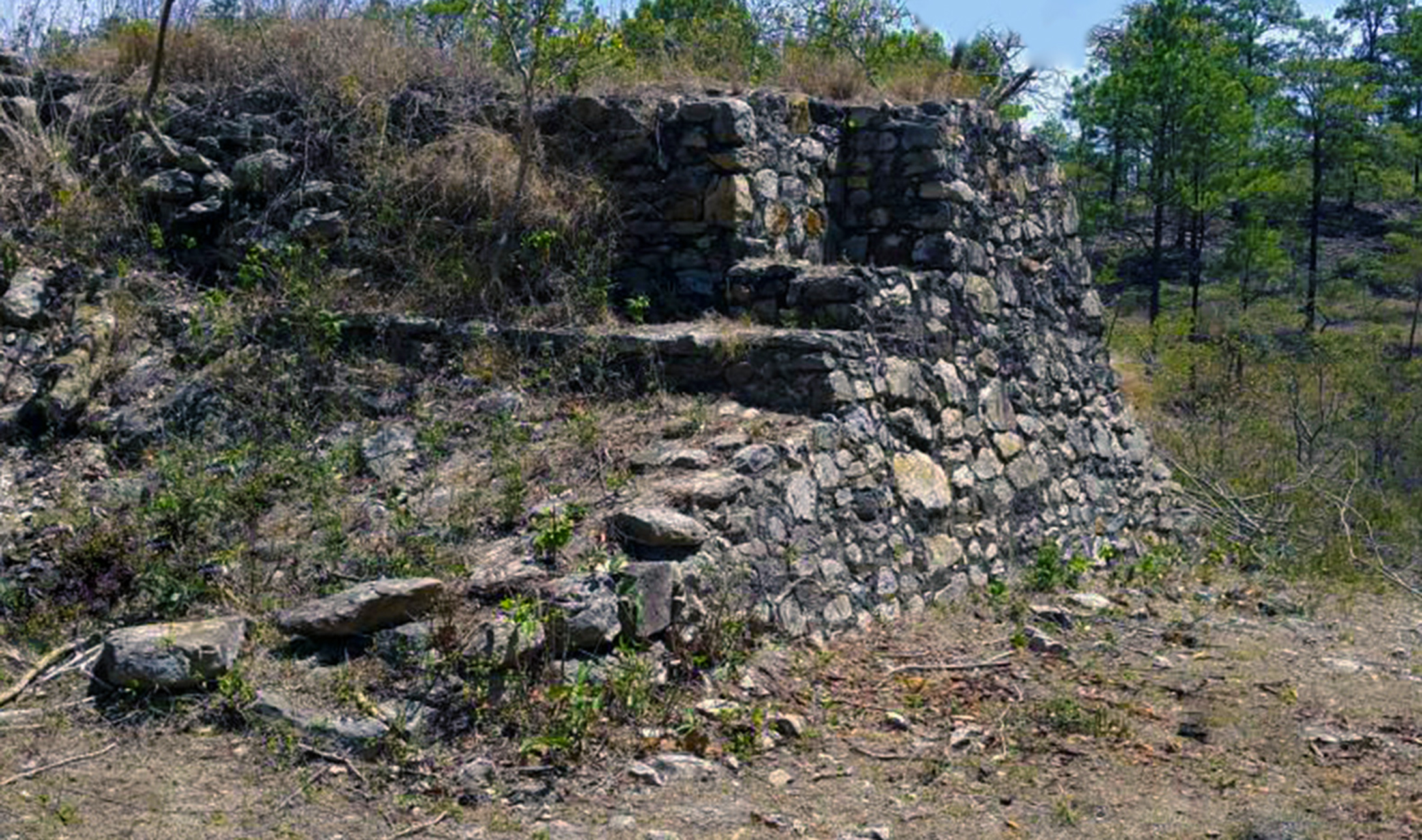
Tenampua sits in a pine forest characteristic of central Honduras, where temperatures hover between 15 and 21 degrees Celsius and gusts of wind sweep across the exposed plateau. The archaeological site contains some 250 registered structures, most of them still hidden beneath vegetation. At its core stands a fortress enclosed by walls two to four meters high, with bases ranging from three to seven meters thick. Inside those walls rise stepped pyramidal structures between 6 and 12 meters tall. Beyond the fortress, the site includes mounds, platforms, a Mesoamerican ball court, bleachers, and areas with rock engravings. Nearby caves contain additional rock art. The main defensive wall stretched more than 200 meters in radius, though portions of it have been damaged by looting and destructive activity over the decades. The site was not registered as cultural heritage until 1997, and it is now protected by guards -- a late measure for a place that suffered constant looting for much of the twentieth century.
Ceremony, Refuge, and Abandonment
The Lenca built Tenampua during the late classical Mesoamerican period as a ceremonial center. Its plazas were connected by stone stairways, its elite occupied residential terraces, and its rulers presided over rituals in structures decorated with stucco flooring -- a rarity in the Comayagua region, found elsewhere only at the ancient site of Yarumela in a Preclassical context. Archaeologist Doris Stone documented the stucco floors in 1957. Federico Lunardi, visiting in 1948, reported that lagoons and palaces were still visible, suggesting the site included recreation areas for the ruling class and the priestly caste. Wells and stoneware found on the plateau indicate the Lenca managed a system of aqueducts that captured rainwater and channeled nearby streams for drinking, washing, and storage. Over time, the ceremonial center became more fortress than temple. The remains of walls suggest constant warfare between Lenca manors. Eventually, the surrounding villages were abandoned as people moved to lower elevations in the valley, and Tenampua was left to the pines and the wind.
Explorers, Mapmakers, and Civil War
Squier's 1853 reports electrified the New York historical community, particularly his description of the ball court -- one of the better-preserved structures at the time, with its ends open and a retaining wall at the southern end creating a level playing surface on the mountainous terrain. In the 1920s, archaeologist Dorothy Popenoe mapped the entire site, documenting the layout of mounds, plazas, and connecting stairways. She reconstructed Staircase No. 1 and what she called the "Wall of the upper terrace in the Great Avenue," one of the Lenca elite's residential terraces. Her work remains some of the most detailed documentation of Tenampua's structure. But the site bore other, more violent marks. During the Honduran civil war of 1924, fighting reached the mountaintop. Bullet casings and fragments of soldiers' bones were found in some areas years later, adding a layer of modern conflict to a place that had already known centuries of warfare.
What the Mountain Held
Excavations across decades have turned up ceramics with elaborate engravings and decorations, obsidian arrowheads, and jade carvings. Among the most remarkable finds are statuettes representing deities from Lenca mythology -- Itanipuca, Ilanguipuca, and Icelaca -- now exhibited in museums in Comayagua and Tegucigalpa. A Lenca petroglyph depicting a bird was found in what was once the ball court. The site remains difficult to reach. It sits in a mountainous, wooded area far from inhabited communities, though guides from the area lead interested visitors to the summit. What they find is a place where the wind still sweeps across an exposed plateau, where pine trees grow among walls that once protected a civilization, and where the view of the Comayagua valley below explains everything about why the Lenca chose to build here. From this height, the world is visible. That was the point.
From the Air
Located at 14.23N, 87.55W in the Comayagua valley of central Honduras, about 57 km from Tegucigalpa. The site occupies a prominent mountaintop plateau at 866 meters elevation, surrounded by pine forest. From the air, look for the elevated plateau south of the town of San Antonio with cleared areas amid the tree cover. Best viewed from 3,000-4,000 feet AGL. Nearest airport: Toncontin International (MHTG) in Tegucigalpa, approximately 57 km to the south. Comayagua's Palmerola Air Base (MHCA) is roughly 30 km north. Mountain terrain and afternoon convective weather are common in this region.