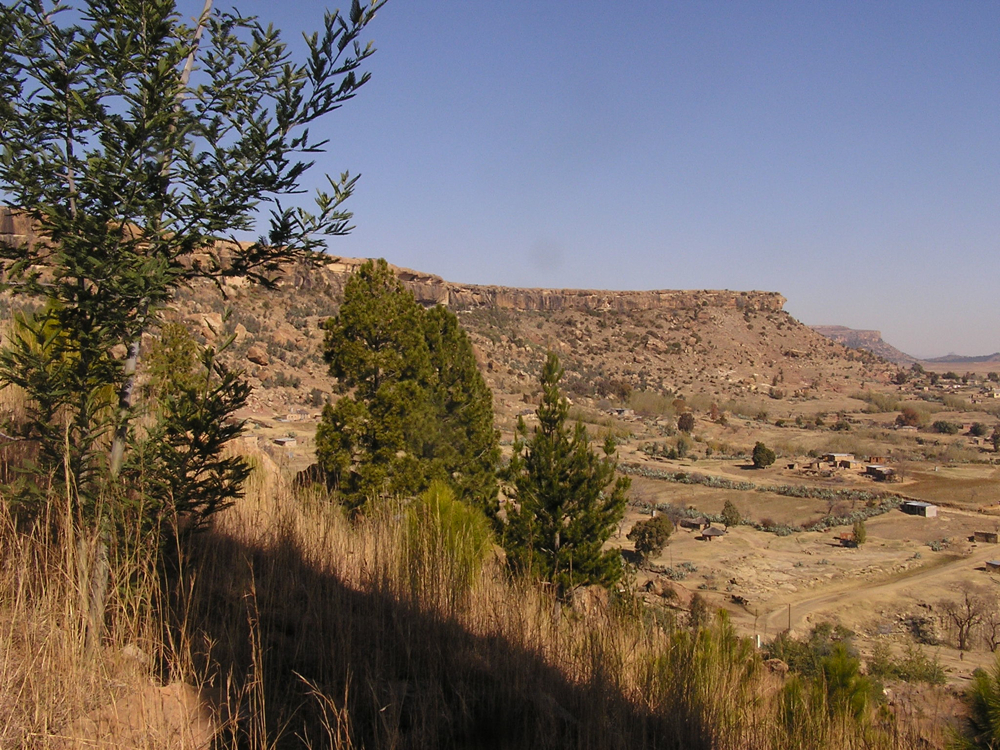
Thaba Bosiu
Moshoeshoe I arrived at night. That detail mattered, because he used it. The year was 1824, and the king and his people were fleeing the devastation of the Mfecane, the series of wars and forced migrations that were tearing southern Africa apart. They found a sandstone plateau rising 106 meters above the Phuthiatsana River valley, its summit ringed by a belt of perpendicular cliffs averaging 12 meters high, with eight natural springs and six narrow passes that could be defended by a handful of warriors. Moshoeshoe named it Thaba Bosiu, Mountain at Night, and to intimidate his enemies, he spread the story that the mountain grew larger after dark. It was a lie wrapped in poetry, and it worked. No army ever conquered Thaba Bosiu.
A Nation Forged on a Plateau
The Mfecane shattered the political order of southern Africa in the 1820s. Peoples were scattered, communities destroyed, and survivors fled in every direction. Moshoeshoe, who had migrated south from Butha-Buthe with his subjects, saw opportunity where others saw only refuge. From Thaba Bosiu he offered cattle and protection to those fleeing the violence, taking in people from diverse communities and binding them together under his rule. When he judged them safe, he sent some out to settle the surrounding valleys, but many chose to stay. The plateau was large enough to hold the livestock and provisions needed to survive a lengthy siege, and its springs ensured water even when the valleys below ran dry. What emerged was the Basotho nation, a people forged not by shared ancestry but by shared survival. Thaba Bosiu became their capital, and from its flat summit Moshoeshoe organized resistance to European encroachment across the central plateau of South Africa.
The Mountain That Could Not Be Taken
Mzilikazi, the Ndebele king who had fled Shaka Zulu's rule, attempted to storm Thaba Bosiu and failed. European invaders tried in 1852 and were repulsed. But the most dramatic assault came on 18 August 1865, when 6,000 armed Boers of the Orange Free State under Commandant Louw Wepener charged the mountain. The Free State Artillery bombarded the summit while Wepener led the infantry up Khubelu Pass, the main route to the top. The Basotho defenders held their ground. As the afternoon wore on, soldiers peeled away from the assault. By five o'clock, only 100 men remained with Wepener. He reached the top of Khubelu Pass, the only enemy combatant ever to set foot on the summit, and was killed by a bullet to the head. The pass is still known as Wepener's Pass. The siege ground on until January 1866, when General Jan Fick withdrew his forces to regroup.
The Treaty and Its Cost
Starvation accomplished what siege warfare could not. After months of blockade, the Basotho signed a treaty in April 1866 that cost them 3,000 cattle and more than two-thirds of their arable land. The surrendered territory included the western bank of the Caledon River and land along the Orange River, leaving the Basotho with a drastically reduced area for farming. But the villagers on the surrendered land refused to leave. In March 1867, Orange Free State President Johannes Henricus Brand ordered a resumption and intensification of military operations. The Third Free State-Basotho War followed, and when the Boers conquered the lowlands, Moshoeshoe made the most consequential decision of his reign. He requested British protection, which was granted in March 1868, just as a new Boer attack on Thaba Bosiu was imminent. Lesotho became a British territory, and the mountain that had never fallen remained the symbol of Basotho sovereignty.
Cliffs, Springs, and San Paintings
Thaba Bosiu sits 24 kilometers east of Maseru, Lesotho's capital, in the valley between the Orange and Caledon Rivers. Its flat top and cliff-ringed perimeter are visible from a considerable distance, a natural fortress that needs no architect's explanation. The six passes, Khubelu, Ramaseli, Maebeng, Mokachane, Makara, and Rahebe, are the only routes to the summit, each narrow enough to be held by a small force. The eight springs that water the plateau made it self-sufficient during siege. Nearby, San rock art survives on sheltered cliff faces, a reminder that this landscape was significant to other peoples long before Moshoeshoe's time. Today Thaba Bosiu appears on UNESCO's Tentative List as a World Heritage Site, recognized not just for its natural features but for its role as the birthplace of a nation that endured wars, treaties, and colonialism and emerged as the independent kingdom of Lesotho.
From the Air
Coordinates: 29.35°S, 27.67°E, in the Maseru District of Lesotho, 24 km east of the capital Maseru. The plateau rises about 106 m above the Phuthiatsana River valley to 1,804 m above sea level. From the air, Thaba Bosiu is a distinctive flat-topped mesa with vertical cliff bands, clearly visible against the surrounding valley. The Caledon River, which forms the Lesotho-South Africa border, lies to the west. Nearby: Moshoeshoe I International Airport (FXMM) at Maseru, approximately 12 nm west. Bloemfontein (FABL) lies approximately 80 nm northwest. The terrain is generally lower and gentler here than in the eastern Maloti highlands, with elevations around 1,600-1,800 m in the surrounding valleys.