The Battlefields Park
Fifty cannons lie scattered across the grass like chess pieces from a game abandoned centuries ago. The Battlefields Park in Quebec City is one of Canada's rare national urban parks, a sweep of green fields and old fortifications perched on the bluffs above the St. Lawrence River. But the peaceful lawns conceal the site of one of the most consequential military engagements in North American history. On September 13, 1759, the Battle of the Plains of Abraham lasted roughly fifteen minutes, killed both commanding generals, and transferred control of New France from the French crown to the British. Six months later, the French fought back at the Battle of Sainte-Foy on the ground that is now Des Braves park. Together, these few acres of Quebec soil changed the trajectory of an entire continent.
Fifteen Minutes That Remade a Continent
The Battle of the Plains of Abraham unfolded with shocking speed. British General James Wolfe had spent months besieging Quebec City from across the river, but on the night of September 12, 1759, his troops scaled the steep cliffs west of the city under cover of darkness. By dawn, roughly 4,500 British soldiers stood in formation on the Plains. French General Louis-Joseph de Montcalm, rather than waiting for reinforcements, marched his men out to meet them. The British held fire until the French were within forty yards, then unleashed devastating volleys. Within fifteen minutes, the French line broke. Both Wolfe and Montcalm were mortally wounded -- Wolfe dying on the field, Montcalm the following morning. The battle's brevity belied its significance: it effectively ended French colonial rule in North America and set the stage for the British Empire's dominance over Canada.
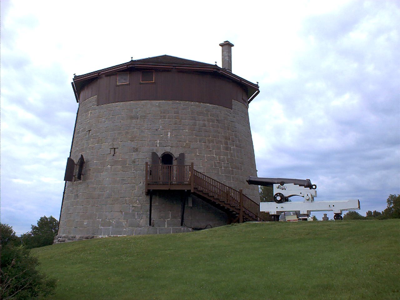
The Towers That Never Fired a Shot
Four squat Martello towers once screened the western approach to Quebec City, built by the British between 1808 and 1812 to prevent an American siege of the city walls. Governor James Craig ordered their construction along an axis bisecting the Plains from northwest to southeast, each positioned to cover its neighbor in mutual defense. The towers were engineering marvels of their time: their rounded walls deflected cannonballs, their limited openings frustrated any attempt to storm them, and their doors sat at twice the height of a man, reachable only by a removable ladder pulled up behind the last defender. Yet these formidable structures never faced combat. By the 1860s, the development of rifled artillery rendered their thick masonry walls obsolete. Tower No. 3 was demolished in the 1900s, but three survive. Tower No. 1 is open to visitors in summer, its three floors now displaying the military engineering that made these structures so fearsome -- and so briefly useful.
A Park Born from Memory
For over a century after the battles, the Plains of Abraham remained open ground without formal protection. It was not until March 17, 1908, that legislation established The Battlefields Park, creating one of Canada's first national urban parks. The National Battlefields Commission, a federal agency, was appointed to manage the site, and it has maintained its own police service since 1948. The park today stretches across the Plains of Abraham and the adjacent Des Braves park, where the 1760 Battle of Sainte-Foy saw the French achieve a pyrrhic victory -- winning the field but unable to retake Quebec City. Walking trails wind through the grounds past the collection of approximately fifty historical artillery pieces, each a silent reminder of the firepower that once thundered across these fields. An interpretive centre tells the story of both battles and the two empires that clashed here.
Concerts Where Armies Once Clashed
The Battlefields Park has evolved into something its martial founders could never have imagined. The same rolling fields where British and French soldiers fell now host outdoor concerts, particularly during Quebec's national festival celebrations. Families picnic on the grass where musket balls once flew. Joggers trace paths along the old defensive lines. The three surviving Martello towers, designated a National Historic Site in 1990, stand as architectural curiosities amid the park's tree-lined paths -- their removable roofs long since replaced with permanent ones that mimic the originals. The park forms part of the larger Fortifications of Quebec National Historic Site, linking it to the ramparts and gates of the old walled city. It is a place where history is not locked behind glass but spread across open ground, inviting visitors to walk the same earth where the fate of North America was decided in a quarter of an hour.
From the Air
The Battlefields Park is located at 46.7997N, 71.2208W, spread across the bluffs southwest of Old Quebec City above the St. Lawrence River. From the air, it appears as a large expanse of green parkland immediately west of the Citadelle and the old walled city. The Martello towers are visible as small circular structures dotting the park. The park's linear shape, running northwest to southeast, is distinctive. Best viewed at 2,000-4,000 feet AGL. Nearest airport is CYQB (Jean Lesage International Airport), approximately 8 nm to the west-southwest. The St. Lawrence River provides an unmistakable reference for orienting to the site.