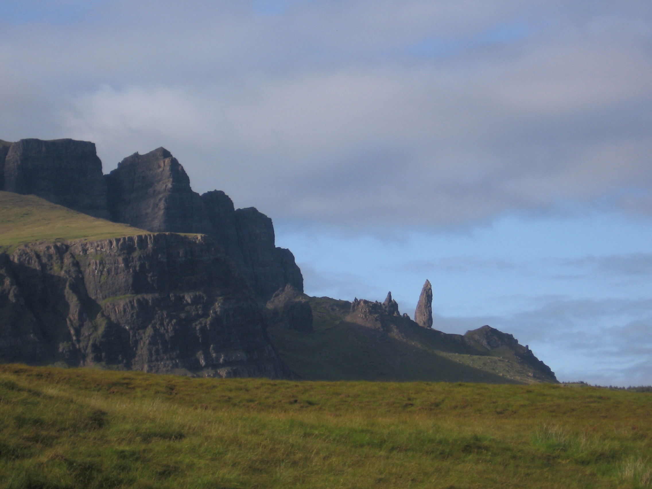
The Storr
In January 2012, a film crew from Ridley Scott's Prometheus arrived at the Old Man of Storr to shoot an alien planet. They could have saved the plane ticket. The fifty-metre basalt pinnacle, standing like a sentinel below the Storr's eastern cliffs, already looks like nothing on Earth -- a remnant of ancient landslips that shattered a volcanic ridge into a sculpture garden of rock towers, gullies, and tilted slabs. The area in front of those cliffs is called the Sanctuary, and the name fits: this is a place set apart, where geology has created something that feels less like a mountain and more like a cathedral ruin, open to the sky and to the horizontal rain that is Skye's most reliable weather.
The Longest Landslip in Britain
The Storr sits on the Trotternish peninsula, the northernmost finger of Skye. Its eastern face is the product of the Trotternish landslip -- the longest such feature in Great Britain, a belt of collapsed terrain stretching for miles along the peninsula's spine. The mountain itself rises on the west side as gentle grassy slopes, misleadingly pastoral. On the east, it drops away in sheer cliffs and towers of gabbro and basalt, the wreckage of a volcanic complex that erupted during the Paleogene period, roughly sixty million years ago. Ice sheets finished what gravity started, carving the pinnacles and deepening the gullies. The Storr is also the type locality for gyrolite, a mineral first identified here -- one of those quietly significant facts that geology insists on tucking into spectacular scenery.
Walking the Sanctuary
A well-constructed path leaves the A855 just north of Loch Leathan and climbs through a clearfell area that was once a conifer plantation. Most visitors go no further than the Sanctuary, content to wander among the pinnacles and crane their necks at the cliffs above. The Old Man of Storr -- Bodach an Stoir in Gaelic -- stands at the heart of it, a fifty-metre column of rock that leans slightly, as if listening. For those who want the summit, the recommended route skirts below the eastern cliffs heading north, then doubles back southward along the ridge via Coire Scamadal. The temptation to take shortcuts through breaks in the cliffs is real but unwise: the rock is loose, the slopes are steep, and what looks like a shortcut from below may not save time or skin. The Storr can also be climbed as part of a much longer expedition following the full length of the Trotternish landslip, a walk that takes in the Quiraing and some of the most dramatic ridge scenery in Scotland.
Art on the Mountain
In the summer of 2005, one of Britain's largest environmental artworks was staged on the walk up to Coire Faoin at the base of the Storr cliffs. Created by the Scottish arts company NVA and directed by Angus Farquhar, the installation included music by Geir Jenssen and Paul Mounsey, live performance by Gaelic singer Anne Martin, and recordings of the works of Sorley MacLean -- the great Raasay-born poet whose Gaelic verse gave voice to landscapes exactly like this one. Lighting designer David Bryant, who won a Plasa award for his work illuminating the Storr, died from cancer in 2007; this was his last major environmental project. In October 2009, a photograph of the pinnacles looking across to Raasay and South Rona won Britain's landscape photograph of the year. The mountain keeps generating images of itself, as if it cannot quite believe its own appearance.
Standing in the Sound
From the summit of the Storr, the view opens across the Sound of Raasay to the island of the same name, and beyond it to the Scottish mainland. To the south, the Black Cuillin ridge cuts the horizon. To the north, the Trotternish landslip extends toward the Quiraing. It is a view that compresses Skye's entire geological story into a single panorama: volcanic fire, glacial ice, and the slow patient work of gravity pulling the land apart. The Storr is not the highest point on the peninsula -- that distinction belongs to other summits along the ridge -- but it is the most dramatic, the place where the island's character is most fully expressed. People have been climbing it for centuries, and the path from the A855 now carries thousands of visitors each year. Yet the Sanctuary retains its power. The pinnacles do not diminish with familiarity. The cliffs do not shrink. And the Old Man still stands, leaning slightly, listening to something the rest of us cannot hear.
From the Air
Located at 57.51N, 6.18W on the Trotternish peninsula of the Isle of Skye. The Storr's eastern cliffs and the Old Man of Storr pinnacle are distinctive landmarks visible from altitude. Nearest airport is Broadford airstrip on Skye; nearest ICAO airport is Inverness (EGPE). Best viewed at 3,000-5,000 feet for the full Trotternish landslip ridge. The A855 road runs along the coast below.