Three Bays Protected Area
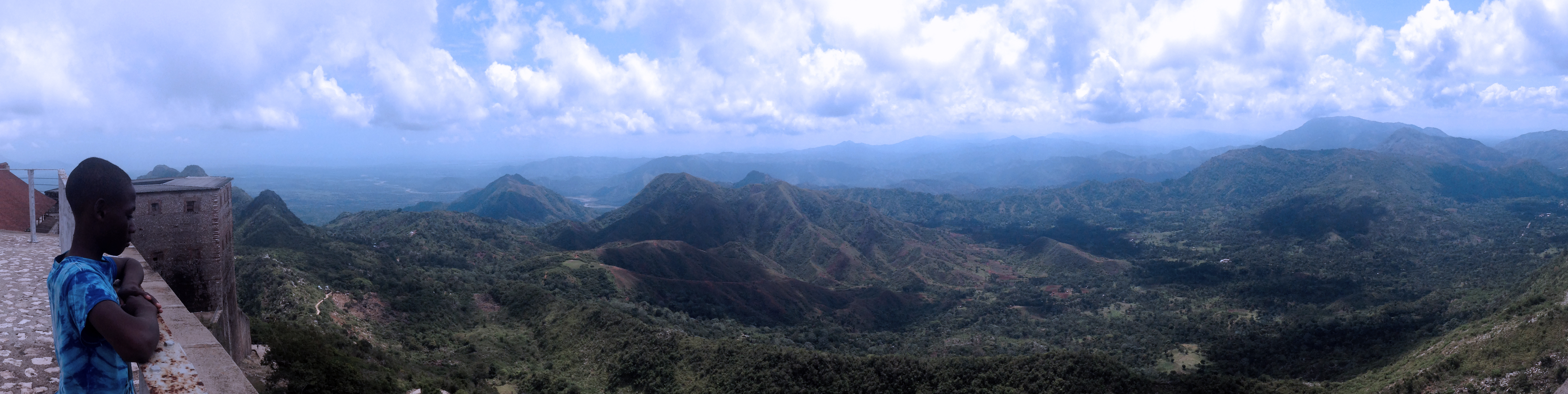
From the ramparts of the Citadelle Laferriere, the mountaintop fortress that Henri Christophe built to guard a newly free nation, you can see it stretching northeast toward the Dominican border: a 40-kilometer arc of turquoise water, dark mangrove shoreline, and pale sandbars that marks the Three Bays Protected Area. Established by presidential decree on March 21, 2014, this 75,000-hectare marine and coastal reserve protects some of the healthiest coral reefs, seagrass meadows, and mangrove forests remaining in Haiti - ecosystems that have survived centuries of colonial exploitation, political upheaval, and relentless fishing pressure. It is the first protected area in Haiti to be jointly managed by a government agency and a private conservation organization, an experiment in shared stewardship for a country where the land and sea have rarely been spared.
Between Two Rivers
The protected area spans Haiti's northeastern coast from the Massacre River on the Dominican border to the Grande-Riviere-du-Nord in the west, a stretch of roughly 40 kilometers with boundaries reaching from the 12-mile territorial sea limit inland to the 10-meter topographic contour line. Its perimeter traces approximately 170 kilometers. At the western edge sits Cap-Haitien, Haiti's second-largest city and the capital of the Nord department. At the eastern boundary lies Fort Liberte, capital of the Nord-Est department and one of the country's oldest cities - the place where Haiti's independence was formally proclaimed. The protected area shares a border with several Dominican reserves, including Parque Nacional Manglares de Estero Balsa and Parque Nacional Submarino de Monte Cristi, creating a rare cross-border corridor of protected marine habitat on the island of Hispaniola.
Reef, Root, and Grass
Beneath the surface, the Three Bays harbor what scientists describe as some of the most extensive fringing and barrier coral reefs in Haiti. These are not pristine systems - nothing in Haiti's waters has escaped the pressures of overfishing, sedimentation from deforested hillsides, and climate-driven bleaching events. But they are resilient ones. The reef complexes share the shallows with vast seagrass beds, underwater meadows that serve as nurseries for juvenile fish, foraging grounds for sea turtles, and some of the most efficient carbon sinks in the marine world. Along the shoreline, mangrove forests knit land and sea together, their tangled root systems filtering sediment, buffering storm surges, and sheltering the larval stages of fish and crustaceans that local communities depend on for food and income. Onshore, the coastal plains support dry tropical forests and brackish water habitats that round out an ecosystem of unusual biological diversity for a country often defined by its environmental challenges.
Ghosts of Hispaniola
Long before colonial ships appeared on the horizon, the Taino people inhabited these bays and coastlines, fishing the reefs and farming the coastal lowlands. Christopher Columbus arrived on this stretch of Hispaniola's north coast during his first voyage, setting in motion the Spanish colonization that would decimate the indigenous population and reshape the island's ecology. French colonization followed, transforming the western third of Hispaniola into Saint-Domingue, the most profitable slave colony in the Caribbean. The sugar plantations that enriched France stripped the hillsides of forest, sending sediment cascading into the bays below - the beginning of an environmental degradation that continues today. Then came the revolution. The enslaved people of Saint-Domingue rose in 1791, and by 1804, Haiti became the first Black republic in the Western Hemisphere. The Citadelle Laferriere, built on a mountaintop roughly 10 miles southwest of the protected area, stands as a monument to that hard-won independence and offers a panoramic view of the coastline the Three Bays now protect.
Guardians of the Bays
The Three Bays Protected Area holds IUCN Category IV status - a Habitat and Species Management Area - designating it as a site where active intervention is expected to maintain the ecosystems within it. What makes it distinctive in Haiti is its governance. It is the first protected area in the country to be co-managed by the Agence Nationale des Aires Protegees, the government's protected areas agency under the Ministry of the Environment, and the Fondation pour la Protection de la Biodiversite Marine, a Haitian nonprofit known by its French acronym FoProBiM. A management plan covering 2017 to 2027 lays out conservation goals for the decade. The challenges are enormous. Regional communities depend heavily on fishing, and the area is described as extremely overfished. Sun-dried fish strung along racks in villages like Caracol speak to a livelihood that has not yet found equilibrium with the ecosystems that sustain it. Balancing the immediate needs of coastal communities with the long-term health of the reefs, mangroves, and seagrass beds they depend on is the central tension the Three Bays must navigate - a tension that plays out across every protected area in the developing world, but here with particular urgency.
From the Air
Located at 19.80N, 72.00W along Haiti's northeastern coast. The protected area stretches roughly 40 km east-west from near Cap-Haitien (Hugo Chavez International Airport, MTCH/CAP) to the Dominican border at the Massacre River. From altitude, the coastline reveals the contrast between turquoise reef-sheltered shallows, dark mangrove shoreline, and deforested brown hillsides. The Citadelle Laferriere is visible as a prominent structure on a mountaintop roughly 10 miles southwest. Fort Liberte's bay is a distinctive natural harbor at the eastern end. The Dominican border and Monte Cristi's adjacent marine parks are visible to the east. Port-au-Prince's Toussaint Louverture International Airport (MTPP/PAP) is approximately 200 km to the south.