Three Parallel Rivers
Trace the Yangtze, the Mekong, and the Salween to their upper reaches in Yunnan province, and something remarkable happens. For over 300 kilometers, these three rivers run roughly parallel, separated by mountain ranges with peaks above 6,000 meters but never more than about 70 kilometers apart. Then they diverge spectacularly. The Salween empties into the Indian Ocean at Moulmein in Burma. The Mekong reaches the South China Sea south of Ho Chi Minh City in Vietnam. The Yangtze flows east to Shanghai and the East China Sea. Three rivers born as neighbors, ending on three different coasts. UNESCO granted this region World Heritage status in 2003, recognizing what the landscape itself makes obvious: this is one of the most extraordinary geological and biological convergences on the planet.
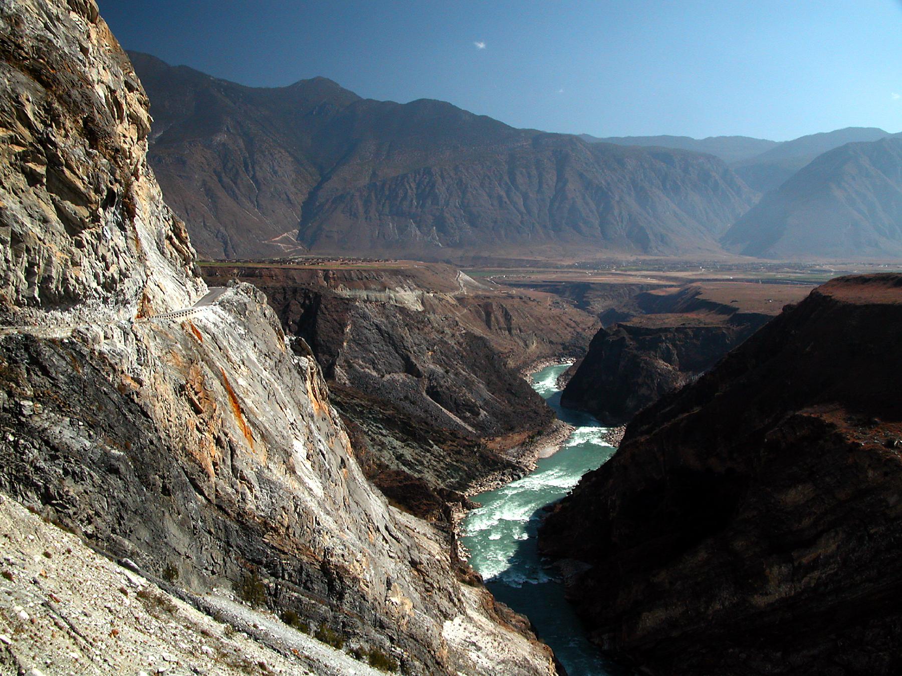
Where Continents Collided
The topography that forces three great rivers into parallel channels is the result of the Indian subcontinent's ongoing collision with the Eurasian Plate, a tectonic event that began roughly 50 million years ago and continues today. The Hengduan Mountains, running predominantly north to south, were carved and compressed into a series of deep gorges and soaring ridges by the same forces that built the Himalayas. The protected areas extend across 15 core zones totaling 939,441 hectares, with buffer areas adding another 758,978 hectares, spanning a region 180 kilometers by 310 kilometers. The highest peak within the protected areas reaches 6,740 meters in the Baima-Meili Snow Mountain range. UNESCO describes the site's topographical features, from gorges to karst formations to glaciated peaks, as the product of being at a "collision point" of tectonic plates.
Five Rivers, One Neighborhood
The three parallel rivers are not the full story. Running slightly to the west is the gorge of the N'Mai River, the main tributary of the Irrawaddy. About 100 kilometers further west lies the watershed of the Lohit River, a tributary of the Brahmaputra and the greater Ganges system. In this single mountainous region, adjacent headwaters feed five of Asia's most significant rivers: from east to west, the Yangtze, Mekong, Salween, Irrawaddy, and Ganges-Brahmaputra. All five rank among the continent's top 15 rivers by volume or length. The implications are staggering. Water that falls on one ridge nourishes rice paddies in Shanghai; rain on the next slope irrigates the Mekong Delta; precipitation a few valleys over reaches the Bay of Bengal. Geography rarely concentrates so much consequence in so small a space.
A Temperate Eden
UNESCO calls the Three Parallel Rivers region potentially "the most biologically diverse temperate region on earth." The numbers support the claim. Around 6,000 plant species inhabit the protected areas, including more than 200 varieties of rhododendron and over 100 species each of gentians and primulas. The fauna is equally remarkable: 173 mammal species, 81 of them endemic, and 417 bird species, 22 found nowhere else. Snow leopards, clouded leopards, and Indian leopards share these mountains. The endemic black snub-nosed monkey clings to life in the high forests. Red pandas, hoolock gibbons, and Asian black bears move through the understory. Among the rarer birds are the Ward's trogon, the black-necked crane, and the Lady Amherst's pheasant. Precipitation ranges wildly, from 4,600 millimeters annually in the Dulongjian area to just 300 millimeters in the upper Yangtze valleys, creating a mosaic of microclimates that sustains this extraordinary diversity.
Peoples of the Gorges
The region's human diversity mirrors its biological richness. Many of the 25 ethnic groups found in Yunnan province live within the Three Parallel Rivers area, including the Derung, the smallest of all China's officially recognized minority groups. Tibetan communities occupy the higher elevations, while the Nu people, the Lisu, the Bai, the Pumi, and the Naxi populate the valleys and lower slopes. Many of these communities still wear traditional dress as everyday attire, not as performance for tourists but as a living expression of identity. Nearby lies the Old Town of Lijiang, itself a UNESCO World Heritage Site, where the Naxi culture has persisted for centuries. Joseph Rock, the Austrian-American explorer and botanist, documented these gorges and their peoples in a 1926 National Geographic article titled "Through the Great River Trenches of Asia," a piece that helped introduce the Western world to this hidden corner of China.
From the Air
Located at approximately 27.90N, 98.41E in northwestern Yunnan province, China, within the Hengduan Mountains. The protected areas span an enormous region from roughly 25N to 29N. Peaks exceed 6,000 meters, with the highest at 6,740 meters in the Meili Snow Mountain range. The three rivers (Jinsha/Yangtze, Lancang/Mekong, Nujiang/Salween) are visible as parallel north-south valleys from cruising altitude. Shangri-La Diqing Airport (DIG) and Lijiang Sanyi International Airport (LJG) are the nearest major airports. Tiger Leaping Gorge is a prominent visual landmark. Extreme terrain and variable mountain weather require careful altitude planning.