Tierra Blanca Joven Eruption
Somewhere around 431 CE, the earth beneath a lake in central El Salvador tore itself open. The explosion that followed ranked a 6 on the Volcanic Explosivity Index -- the same scale that puts Mount St. Helens at a 5. Scientists call it the Tierra Blanca Joven eruption, after the pale young tephra it left behind, and for the Maya communities living across what is now El Salvador, Guatemala, and Honduras, it was the end of the world as they knew it. Pyroclastic flows raced across 10,000 square kilometers, burying the landscape under more than half a meter of pumice and ash. The eruption was one of the largest volcanic events on Earth in the past 7,000 years, and its signature has been found in ice cores drilled from the Greenland ice sheet, more than 8,000 kilometers away.
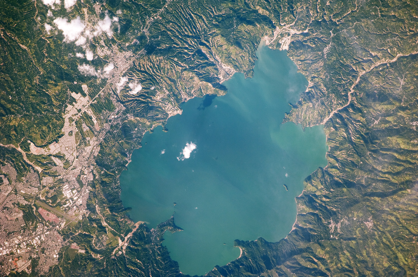
A Lake That Hides Its Violence
Lake Ilopango sits just east of San Salvador, a placid oval of blue water ringed by green hills. Tourists swim in it. Restaurants line its shore. Nothing about its calm surface suggests what lies beneath: the caldera of one of Central America's most violent volcanoes. The Ilopango caldera has erupted multiple times over the millennia, but the Tierra Blanca Joven event dwarfs them all. The eruption produced massive volumes of ejecta -- several times what Mount St. Helens expelled in 1980 -- and sent pyroclastic flows racing outward in every direction. The dense-rock equivalent of the material ejected gives geologists a measure of the blast's true scale, and by that measure, the TBJ eruption sits among the largest Holocene volcanic events worldwide.
Pinning Down the Date
For decades, the eruption's date was debated. Some researchers connected it to the mysterious global climate disruption of 535-536 CE, when crops failed across Europe and the sun dimmed for more than a year. The theory was compelling: a VEI-6 eruption in the tropics could inject enough sulfur into the stratosphere to cool the planet. But precision dating of Greenland ice cores has constrained the TBJ eruption to between 429 and 433 CE -- roughly a century before those extreme weather events. The volcanic ash signature found in those Arctic ice samples is chemically distinct and unmistakable. Whatever caused the climate crisis of the 530s, it was not Ilopango. The eruption had already done its damage and the landscape had already begun its slow recovery.
A Civilization Interrupted
The human cost is harder to quantify than the geological data, but the archaeological record is clear enough. Before the eruption, the region around Ilopango supported thriving Maya communities connected to the broader southern lowland network. Afterward, the area was abandoned. The thick blanket of tephra -- the white earth that gives the eruption its name -- rendered the soil sterile. Agriculture became impossible across a vast swath of what is now El Salvador. Communities that had farmed this land for generations had to leave or die. Some researchers believe the displacement triggered population shifts across the Maya world, pushing refugees north and west into areas that would later become major Classic-period centers. The eruption did not end Maya civilization, but it redrew its map.
White Earth, Long Memory
The tephra from the TBJ eruption still defines the geology of central El Salvador. Road cuts expose the pale layer beneath the surface soil, a visible record of that day fifteen centuries ago. Geologists use it as a stratigraphic marker -- anything below the white layer predates 431 CE; anything above it came after. The layer is thick enough near the caldera to bury buildings, and thin deposits have been identified hundreds of kilometers away. Lake Ilopango itself is the eruption's most obvious legacy: a body of water filling the void left by the caldera's collapse. At 72 square kilometers, it is the largest lake in El Salvador, deep and still, concealing the magma chamber that produced one of the Western Hemisphere's most powerful volcanic events.
From the Air
Coordinates: 13.67N, 89.05W. Lake Ilopango is immediately east of San Salvador and unmistakable from altitude -- a large oval lake filling a volcanic caldera, roughly 11 km by 8 km. The lake's steep-walled rim and the small Islas Quemadas dome in its center are visible from above 5,000 feet. Nearest major airport is El Salvador International (MSLP) at Comalapa, approximately 30 km south. San Salvador's Ilopango International Airport (MSSS) sits on the lake's western shore. The volcanic highlands surrounding the lake provide dramatic terrain at any altitude.