Timgad
On December 12, 1765, a Scottish explorer named James Bruce reached a site in the Aures Mountains and found what he described as "a small town, but full of elegant buildings." Nobody in Europe believed him. It took more than a century for another visitor, British consul Robert Lambert Playfair, to confirm what Bruce had seen: an entire Roman city, its streets and columns preserved beneath centuries of Saharan sand. Timgad had been waiting, its grid intact, its library alcoves still shaped to hold scrolls that had long since turned to dust.
Trajan's Family Monument
Emperor Trajan founded the city around 100 AD and named it with characteristic Roman thoroughness: Colonia Marciana Ulpia Traiana Thamugadi. The first three names honored his mother Marcia, his eldest sister Ulpia Marciana, and his father Marcus Ulpius Traianus. The fourth, Thamugadi, was the Berber name of the place, the plural of Tamgut, meaning peak or summit. It was an apt description for a city perched at roughly 1,000 meters above sea level in the Atlas Mountains. Designed for 15,000 residents, the colony quickly outgrew its orthogonal grid and sprawled beyond the walls in the organic way that cities do when planners underestimate demand.
The Grid That Survived Everything
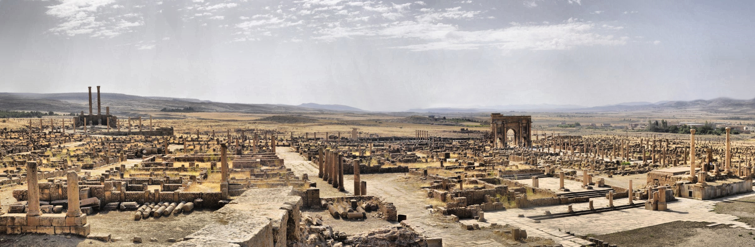
Walk the Decumanus Maximus today and you walk the same east-west axis that Roman engineers surveyed nearly two millennia ago. The grid plan is magnificently visible from above, a textbook illustration of Roman urban design highlighted by a partially restored Corinthian colonnade. The cardo, the north-south artery, terminates at a forum rather than running the full length of the city, a quirk that gives Timgad its distinctive layout. At the western end of the Decumanus, Trajan's 12-meter triumphal arch marks the boundary between city and road. A 3,500-seat theater survives in such good condition that it hosts contemporary productions. Four bathhouses, a basilica, and a Capitoline Temple dedicated to Jupiter, built to approximately the same dimensions as the Pantheon in Rome, round out a city that invested heavily in Roman identity despite being hundreds of miles from Italy.
A Library in the Desert
Perhaps nothing speaks to Timgad's ambitions more clearly than its library. Donated by a citizen named Julius Quintianus Flavius Rogatianus at a cost of 400,000 sesterces, the library occupied a rectangle 81 feet long by 77 feet wide. A large semi-circular reading room was flanked by two rectangular chambers and preceded by a U-shaped colonnaded portico. Oblong alcoves along the walls once held wooden shelves, probably fitted with sides, backs, and doors in the style found at the library of Ephesus. Scholars estimate the space could have accommodated 3,000 scrolls. That a North African frontier city maintained a fully developed library system tells us something important about the culture that thrived here, far from the literary salons of Rome.
Decline, Sand, and Resurrection
Timgad became a center of Christianity in the 3rd century and a stronghold of the Donatist movement in the 4th, when Bishop Optat served as the sect's leading spokesman. The Vandals sacked the city in the 5th century. Berber tribes from the Aures Mountains destroyed it further. The Byzantine general Solomon retook and rebuilt parts of the city in 539 AD, incorporating it into a defensive line against the Moors. But the early Muslim conquests sealed Timgad's fate, and by the 8th century it was abandoned. The Sahara did the rest, burying the ruins under sand that preserved them with an effectiveness no museum could match. French excavations beginning in the 1880s gradually uncovered the city, and UNESCO inscribed it as a World Heritage Site in 1982. Today Timgad stands as a reminder that the Roman world extended far beyond the Mediterranean shore, planting grid-planned cities in mountain passes where the desert began.
From the Air
Located at 35.48N, 6.47E in the Aures Mountains of Algeria, roughly 35 km east of Batna. The ruins present a striking geometric pattern visible at medium altitudes, with the grid plan clearly distinguishable against the surrounding terrain. Best viewed at 3,000-6,000 feet AGL. Nearest airport: Batna-Mostefa Ben Boulaid Airport (DABT) approximately 35 km west. The site sits on an elevated plateau at about 1,000 meters elevation. Clear skies predominate.