Tinallinge
Climb the mound and you are standing on something older than the Roman Empire. The wierde at Tinallinge - the artificial hill the village sits on - was built sometime around 500 BC by people who needed a piece of dry land in country that was not always dry. It covers six hectares and rises 3.7 meters above sea level, which sounds modest until you realize that the surrounding countryside barely rises at all. At the top of the mound sits the Church of Our Lady, built around 1280. Around the church, a few houses, a former village school, a renovated parsonage. After about 1900 the village basically stopped building. Twenty-five hundred years of habitation and the place is still the size of a generous farmyard.
The People of Ingald
The oldest written record of the village is from the tenth century, when it was called Ingaldinghem - which means "residence of the people of the person Ingald." By the eleventh century it had shifted to Ingaldingon, the dative plural form meaning "among the people of Ingald." Then, sometime later, the Dutch preposition to (meaning "at" or "to") attached itself to the front, the way it did with other Groningen toponyms like Tolbert and Taarlo. By 1575 the village name was Tinallinge. Nobody knows who Ingald was. The name records that his people lived here, that they were a recognizable group, that other communities in the marsh referred to them by his name. Two thousand years later that anonymous chieftain or patriarch is the village's only inheritance from the Iron Age - one syllable stretched across twenty-five hundred years.
Built on Survival
A wierde - or terp, as the same structure is called in Friesland - is a mound of earth piled up by hand to give a settlement a dry place to stand before the era of dikes. The Wadden Sea pushed regular high tides far inland, and the people of the Groningen marsh had a choice: build hills or drown. They built hills. Tinallinge's mound went up around 500 BC and grew across centuries as families added to it, basket by basket. The old encircling road around the wierde is still partly intact - you can walk the perimeter of a Bronze Age civic project and see how the village wraps around its high ground. Most of the mound is undeveloped today. In 2003, the wierde itself was declared an archaeological monument, recognizing the earthwork as the village's deepest artifact.
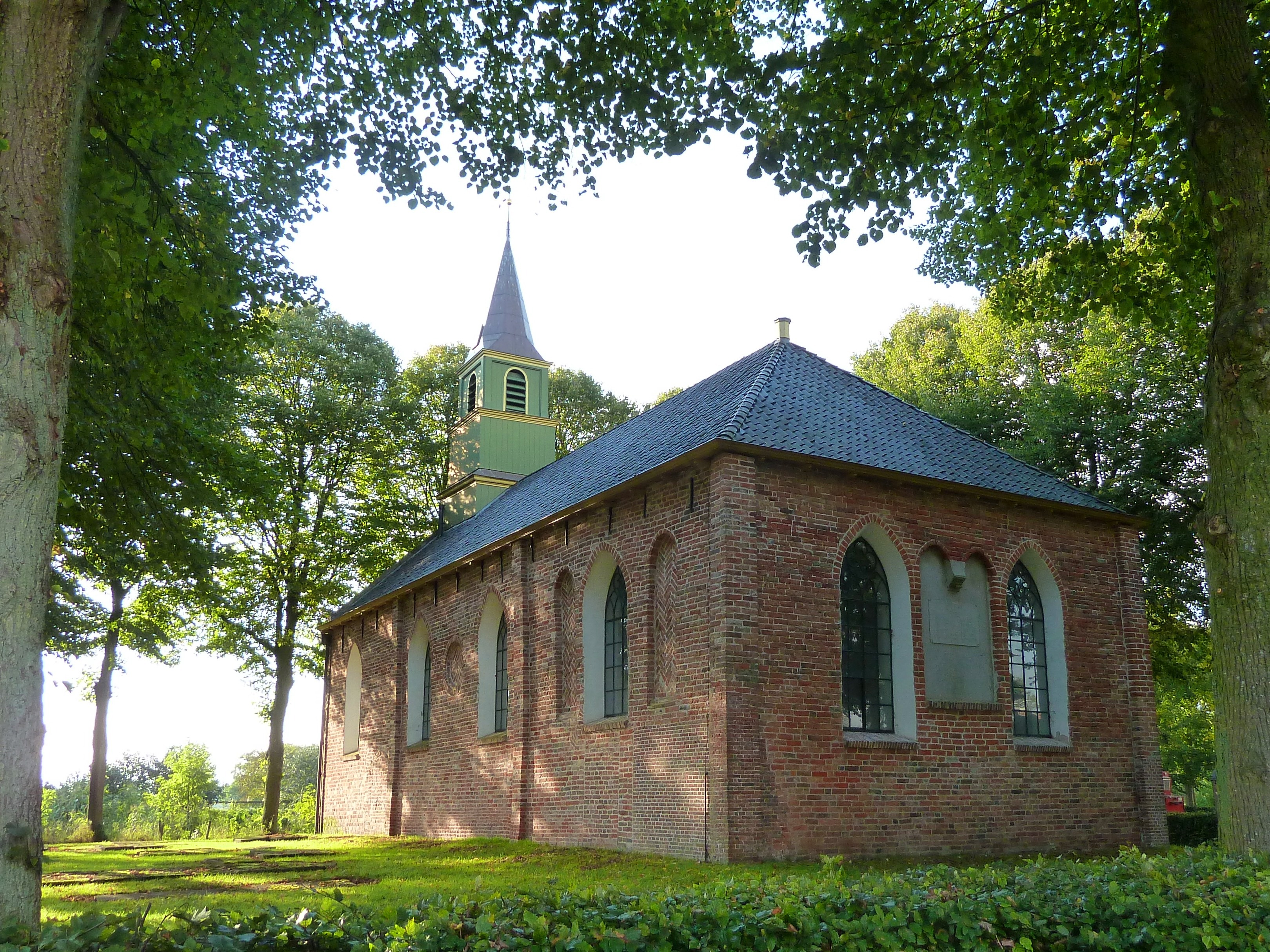
The Church on Top
The Church of Our Lady at the crown of the wierde dates to about 1280 - a small medieval brick church that has survived seven centuries of weather, reformation, and shifting congregations. The most recent restoration was in 2003. By 2010 the local congregation had grown too small to maintain the building, and they transferred it to the Stichting Oude Groninger Kerken, a foundation devoted to preserving the old churches of Groningen province. The foundation looks after dozens of these village churches, some now used for concerts and quiet visits rather than weekly services. Around the church, the village's other historic buildings cluster: the former Protestant village school from the nineteenth century (now the village hall), the schoolmaster's house next door, and the parsonage - called a weem in the local dialect - rebuilt in the early twenty-first century in the old style. North of the church grows a herb garden with an orchard.
The Vanished Borg
Just north of the village once stood a borg - a fortified manor house, the Groningen equivalent of a small castle - called Ter Weer. The epitaph of Barthold Tjarda van Starkenborgh, dated 1573, identifies him as the chieftain in Eenrum and Tinallinge, suggesting the family seat was already established here, though the borg itself was not mentioned in writing until 1662. The Tjarda van Starkenborgh family held the property until 1671, after which it passed to Pompeius Gruys. In 1720 the borg was demolished. A farm of the same name - Ter Weer - was built on the spot, which is the way Dutch land tends to work: the buildings change, the field names persist. Tinallinge sits on a mound built by people whose names are lost, beneath a church built by Catholics and now run by a heritage foundation, beside a vanished manor remembered by a farm. Everything overlaps. Nothing entirely disappears.
From the Air
Tinallinge sits at 53.357°N, 6.534°E in the Hogeland region of Groningen province, about 17 km north of the city of Groningen and just southeast of the slightly larger village of Baflo. From the air the village reads as a tight cluster of buildings raised slightly above the surrounding pasture - the wierde gives it a subtle elevation that catches low-angle light and shadow. The medieval church at the top is the visual anchor. Nearest airport is Groningen Airport Eelde (EHGG), about 25 km south. Best viewed at low altitude in clear conditions to make out the mound's outline against the flat polderland.