Toghrol Tower
Nobody agrees on who is buried here. For nearly a thousand years, the 20-meter brick tower on the outskirts of Rey has stood open to the sky, its original conical dome long since shaken loose by an earthquake, while historians argue over the identity of its occupant. The leading candidate is Tughril I, founder of the Seljuk Empire, who died in Rey in 1063 after building a dynasty that stretched from Central Asia to the Mediterranean. But other scholars attribute the tomb to Khalil Sultan, grandson of Timur, or to the obscure figure Fakhr Deilami. The tower keeps its secret behind walls of intricately laid brick, indifferent to the controversy.
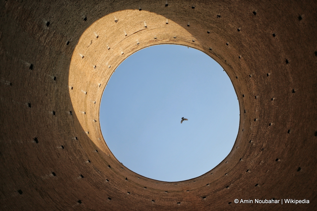
Geometry Against Earthquakes
The tower's most remarkable feature is invisible until you count its sides. From a distance, it appears cylindrical. Up close, the exterior resolves into a polygon with 24 angles, a geometric choice that engineers believe distributes seismic force more evenly than a simple circle. Iran sits atop one of the world's most active tectonic zones, and the fact that this structure has survived since the 12th century while its dome did not speaks to the polygon's structural advantage. The brickwork itself is quintessentially Seljuk: precise, geometric, and decorated in patterns that turn functional masonry into ornament. Kufic inscriptions once ringed the top of the tower, though later restorations obscured much of the original calligraphy.
A Beacon on the Silk Road
The tower may have served a purpose beyond the funerary. According to some accounts, fires were lit at the top on foggy nights to guide Silk Road caravans approaching Rey from Khorasan. The city of Rey was one of the great stops along the ancient trade route, a metropolis that rivaled Baghdad in its medieval prime. Travelers crossing the Iranian plateau would have needed landmarks, and a 20-meter tower with a flame at its summit would have been visible for miles across the flat approaches to the city. Some researchers also argue that the tower functioned as a kind of sundial, its 24 facets casting shadows that shifted with the hours, allowing the people of Rey to track the time of day by observing which face caught the sunlight.
The Bones of Dispute
The burial question refuses to resolve itself. The historical text Mahmalottavarikh states plainly that Sultan Tughril died in Rey and was buried there. The Turkish historian Faregh Sumer agreed. But the tower has also been attributed to Khalil Sultan, grandson of Timur and a Timurid ruler who lived in the 15th century, three hundred years after the tower's construction. Hassan Karimiyan, in his book on ancient Rey, notes that some scholars link the monument to Fakhr Deilami instead. Mohammad Mohit Tabatabai went further, attributing the building to Ibrahim Khawas. Tabatabai himself was buried beside the tower in 1992, adding one more layer to the site's accumulation of the dead and their stories.
Restorations and Revolutions
The tower's survival has required intervention more than once. In 1884, Naser al-Din Shah Qajar ordered repairs to the crumbling upper sections. His chancellor, Amin al-Sultan, oversaw the work, which included installing marble slabs at the entrance. The restoration saved the structure but destroyed what remained of the Kufic inscriptions. After the 1978 revolution, the tower was abandoned and left to deteriorate. Serious reconstruction did not resume until 1998, continuing through the winter of 2000. Today, District 20 of Tehran Municipality is developing the surrounding two hectares into a cultural center with a library, museum, and restaurant. The tower that may have guided Silk Road travelers is finding a new role as the anchor of a neighborhood still searching for its identity on the sprawling southern edge of Tehran.
From the Air
Located at 35.60N, 51.45E in the southern suburbs of Tehran, in the ancient city of Rey. The tower stands 20 meters tall and is visible as a cylindrical structure amid low urban development. Best viewed below 3,000 feet. Nearest major airport is Tehran Imam Khomeini International (OIIE), approximately 35 km southwest. Mehrabad International Airport (OIII) is about 15 km northwest. The surrounding area is flat, making the tower distinguishable from the air in clear conditions.