Tombstone: The Yukon's Gothic Mountains
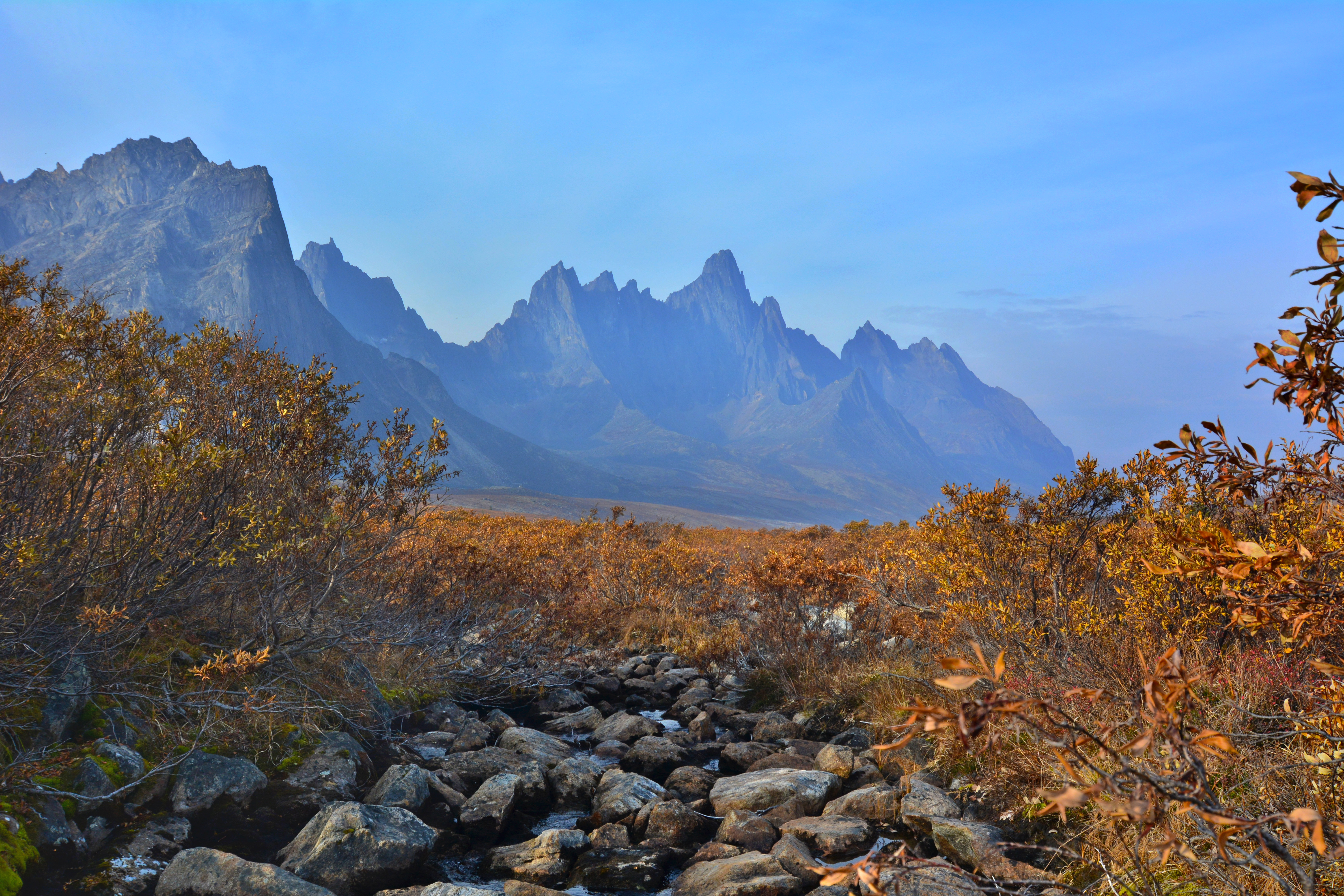
The mountains at Tombstone Territorial Park look like a cathedral designed by Tim Burton. Black granite spires rise from the tundra, jagged and dramatic, their shapes inspiring the morbid name. The park occupies some of the most photogenic wilderness in North America - yet most visitors see it only from the Dempster Highway, which passes through its western edge on the way to the Arctic Ocean. Those who stop find backcountry worth the detour: alpine lakes, grizzly-inhabited valleys, and peaks that challenge experienced mountaineers. The Dempster brings traffic; the wilderness beyond the road brings perspective on just how big and empty this country really is.
The Peaks
Tombstone's signature mountains are granite monoliths eroded into spires, towers, and jagged ridges. Tombstone Mountain itself is the most photographed - a black peak reflected in Grizzly Lake at dawn. Mount Monolith rises as a single shaft of rock. The Hart and Goldensides ranges offer additional drama. The granite is part of a batholith, an intrusion of igneous rock that resisted erosion while surrounding rock disappeared. The result is a landscape that looks too dramatic to be real, like a fantasy illustration that somehow became geography.
The Ecosystem
Tombstone protects the southern edge of the northern Ogilvie Mountains - a transition zone between boreal forest and Arctic tundra. The landscape shifts with elevation: spruce forests in valleys, alpine meadows on slopes, barren rock and lichen above treeline. Wildlife is abundant: grizzly bears, Dall sheep, caribou, wolves, wolverines. The Porcupine caribou herd passes through during migrations. The park provides critical habitat for species that range across vast territories; its protection matters beyond its boundaries.
The Access
The Dempster Highway passes along Tombstone's western edge, making it one of the most accessible sub-Arctic wilderness areas in North America. The park boundary begins at kilometer 71.5 from Dawson City; the interpretive center is at kilometer 71.3. Most visitors experience the park from road viewpoints and short trails. The backcountry is more demanding: no maintained trails beyond the front country, route-finding required, stream crossings unbridged. The terrain is challenging even for experienced hikers; the weather changes rapidly; self-sufficiency is essential.
The Season
Summer is brief and intense in Tombstone. The snow melts by late June (sometimes later); it returns by September. July and August offer the most reliable hiking weather, but even then, snow squalls can occur. The mosquitoes in July are legendary - serious preparation is required. Fall colors peak in August and early September, turning the tundra gold and red against the black granite peaks. Winter is beautiful but inaccessible for most travelers; temperatures drop below -40°. The park's drama is year-round; human access is seasonal.
Visiting Tombstone
Tombstone Territorial Park is located 71 kilometers north of Dawson City on the Dempster Highway. The interpretive center (seasonal, summer only) provides maps, information, and backcountry registration. The Goldensides campground offers frontcountry camping. The Grizzly Lake trail (20 km round trip) is the most popular day hike, offering views of Tombstone Mountain. Backcountry camping requires registration; no maintained trails exist beyond established routes. Bear canisters are mandatory; bear spray recommended. Dawson City has full services including hotels, restaurants, and outfitters. The Dempster Highway is unpaved and can be rough; two spare tires recommended. The interpretive center is one of the most scenic highway stops in North America.
From the Air
Located at 64.40°N, 138.35°W in the Ogilvie Mountains, Yukon. From altitude, Tombstone's granite peaks are visible as dark spires rising from the surrounding terrain - clearly distinct from the softer mountains around them. The Dempster Highway is visible as a thin line passing through the park's western section. The landscape is empty - no settlements, few structures, just wilderness extending in every direction. The park's drama is apparent even from aircraft: those black peaks are unmistakable against green tundra and gray rock. This is Yukon at its most photogenic, accessible from the highway but extending into roadless wilderness.