Tomnaverie Stone Circle
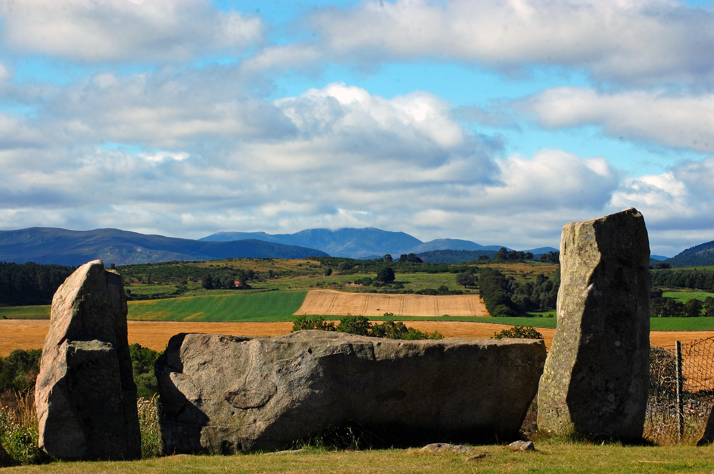
Thirteen granite stones stand on a low hilltop near Tarland in Aberdeenshire, arranged in a circle seventeen metres across. The largest -- a 6.5-ton block of quartz-veined granite -- lies on its side, oriented toward the southwest, pointing across the Howe of Cromar toward the distant peak of Lochnagar. This is the recumbent stone, and everything about Tomnaverie was designed around it. Built around 2500 BC, the circle belongs to a tradition unique to northeast Scotland: the recumbent stone circle, a monument type found in more than seventy locations across Aberdeenshire and nowhere else in the world with quite the same concentration.
The Recumbent Tradition
In a recumbent stone circle, the largest stone is always placed on its side, typically along the southern or southwestern perimeter. Flanker stones -- the tallest uprights in the circle -- stand on either side of the recumbent. The remaining stones decrease in height as they curve around to the opposite side of the ring. Builders chose hilltops with commanding views, and the recumbent was usually oriented toward a landmark on the far horizon. At Tomnaverie, the eastern flanker stands 1.8 metres high and weighs 2.5 tons; the western flanker is 1.9 metres high and weighs 3.5 tons. The recumbent itself is a pale block of granite intruded with quartz, lighter in colour than its darker attendant stones, and bearing two cup marks -- one on top, one on its outer face.
Rescued from the Quarry
By 1930, Tomnaverie was in ruins. A neighbouring quarry had eaten to within a metre of the standing stones. Only four uprights remained in position. The quarry workers had possibly tipped the recumbent onto its face to prevent it falling into the pit, and both flanker stones had been pulled from their sockets and knocked outward. One had slid down into the quarry itself. In 1926, the archaeologist Alexander Keiller succeeded in halting the quarrying after what he described as the 'hectic riot which I created in the quarry last summer.' The monument was designated a scheduled monument in 1927 and taken into state guardianship in 1930 -- but guardianship meant little more than a fence and mown grass. By 1995, Aubrey Burl could write that Tomnaverie was 'a wreck... its stones are now a jumble.'
What the Dig Revealed
A major excavation in 1999 and 2000, led by Richard Bradley, changed not only Tomnaverie but the understanding of recumbent stone circles across Scotland. The hilltop had first been used for funeral pyres, creating a mound of burnt residues and cremated human bone. This mound was later enclosed within a polygonal ring cairn, and a platform of stones was extended outward to level the summit. Seven radial lines of boulders divided the cairn into segments like spokes of a wheel. Only after this careful preparation was the stone circle erected on top. The cairn had come first -- not the circle. This reversed the assumption that builders had raised the stones and filled in the centre later. The radial lines apparently pointed toward the places where the uprights would stand, meaning the entire project had been conceived as a single design executed in stages.
Stones Returned to Their Sockets
The excavation found the original sockets of four missing stones, and two of the uprights themselves -- one buried beside its socket, another lying unbroken in the quarry despite having fallen before 1870. These were lifted by crane and lowered back into their sockets. The flankers were returned to their positions. The recumbent was turned and placed level in its original hollow, and in 2003 part of the quarry was backfilled and landscaped. Standing at the circle today, looking across the recumbent toward the southwest, Lochnagar fills the horizon exactly where Burl and Ruggles predicted it would. Whether the alignment with the mountain was deliberate, or whether it coincides with the midsummer moonset during a minor lunar standstill, remains debated. What is not debated is the skill of people who, four and a half thousand years ago, levelled a hilltop, built a platform, and hauled a 6.5-ton stone to a precise position aligned with a mountain thirty kilometres away.
From the Air
Located at 57.12N, 2.85W on a small hilltop about 1 km south of Tarland in Aberdeenshire. The circle is in the Howe of Cromar, a valley surrounded by hills including Lochnagar (30 km southwest), Morven, and Clachnaben. Aberdeen Airport (EGPD) is approximately 30 miles east. Best viewed at 2,000-3,000 ft AGL.