Toro Negro State Forest
Most visitors to Puerto Rico never leave the coast. They know the beaches, the forts of Old San Juan, maybe the well-trodden trails of El Yunque. But deep in the island's mountainous interior, where the Cordillera Central reaches its highest elevations, an entirely different Puerto Rico waits. Toro Negro State Forest -- Bosque Estatal de Toro Negro -- sprawls across seven non-contiguous tracts of land in five municipalities, harboring the island's three tallest peaks and its highest lake. Clouds cling to the ridgelines here, rivers tumble through dense canopy, and the air carries a coolness that feels improbable for a Caribbean island.
The Island's Rooftop
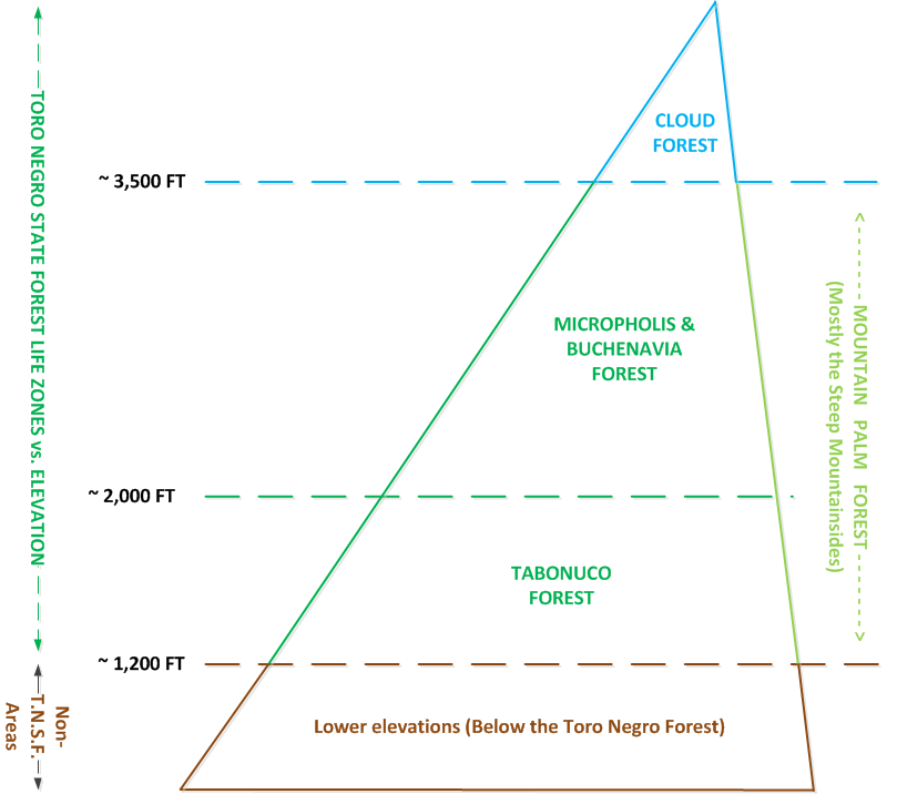
Cerro de Punta, Cerro Jayuya, and Cerro Rosa -- Puerto Rico's three highest peaks -- all rise within or adjacent to Toro Negro's boundaries. The forest sits between the municipalities of Ponce, Jayuya, Orocovis, Ciales, and Juana Diaz, with roughly 40% of its area falling within Ponce's Barrio Anon. At these elevations, the landscape bears little resemblance to the palm-fringed coast below. Mist forests replace mangroves. Epiphytes coat every branch, ferns grow shoulder-high, and the sounds of coqui frogs fill the twilight hours.
Nestled among these mountains is Lake Guineo, the highest lake in Puerto Rico. The forest offers 18 kilometers of trails, an observation tower, two natural swimming pools known locally as charcos, and camping areas threaded by nine rivers and innumerable creeks and waterfalls. It is a place where the island feels vast rather than small.
From Coffee to Cloud Forest
The land where Toro Negro now stands was not always forested. For decades, these mountain slopes served as coffee plantations, the rich volcanic soil and misty elevations producing conditions ideal for shade-grown coffee but devastating for native ecosystems. By the early 1930s, with the coffee economy in decline, Puerto Rico embarked on an ambitious experiment in ecological restoration.
In 1934, the Puerto Rico Reconstruction Administration acquired the depleted lands. By 1935, 1,900 acres of private holdings had been purchased, and one of the Caribbean's largest reforestation campaigns began. Between 1934 and 1945, workers planted over three million seedlings and sowed approximately 19,000 pounds of seeds across 1,856 acres. Twenty-eight species went into twenty-nine different plantations. The forest that visitors walk through today is largely the product of that deliberate effort -- nature guided back into place by human hands after human hands had cleared it.
A Forest Changes Flags
Toro Negro's administrative history mirrors Puerto Rico's own complicated relationship with the United States. When the forest reserve was established in 1935, it was managed by the U.S. government as part of the Caribbean National Forest -- first through the Department of the Interior, then through the Forest Service. The forest was not a distinct entity but the Toro Negro Division of a larger federal holding.
In 1961, a transfer process began that would reshape two of Puerto Rico's most important forests. The federal government ceded 6,817 cuerdas of Toro Negro land to Puerto Rico, keeping nearly 2,000 cuerdas in exchange for Commonwealth-owned forest land adjacent to the Luquillo Unit. That swap created what is now El Yunque National Forest, the federal crown jewel, while Toro Negro became a Commonwealth state forest under Puerto Rico's Department of Natural and Environmental Resources. The trade gave El Yunque its modern boundaries and gave Puerto Ricans ownership of their own mountain heart.
Deep Roots, Living Forest
The origins of forest protection in Puerto Rico reach back further than most people realize. In 1876, Spanish King Alfonso XII issued the first proclamation for the creation of forest reserves on the island -- decades before the American conservation movement gained momentum on the mainland. That early impulse, born of colonial resource management rather than ecological idealism, nevertheless planted the seed for what Toro Negro would eventually become.
Today, the reforested plantations have matured into something approaching genuine wilderness. Since 1962, additional plantings of eucalyptus, mahoe, kadam, and Honduran pine have diversified the canopy. The Area Recreacional Dona Juana, added to the forest in 1962, provides a gateway for visitors seeking the swimming holes and waterfalls that draw hikers up from the coastal cities. Nine rivers originate within Toro Negro's boundaries, feeding waterfalls that cascade through moss-covered rock. In a territory often defined by its coastline, this mountain forest offers proof that Puerto Rico's interior holds wonders of its own.
From the Air
Located at 18.16N, 66.53W in Puerto Rico's Cordillera Central, the island's mountainous spine. The forest is visible from altitude as a dense green expanse on the highest ridgelines, distinct from surrounding agricultural land. Cerro de Punta (4,390 ft / 1,338 m), Puerto Rico's highest point, is within the area. Nearest airports include Mercedita Airport (TJPS/PSE) in Ponce, approximately 15 nm south, and Fernando Luis Ribas Dominicci Airport (TJIG/SIG) in San Juan. The terrain is rugged with peaks exceeding 4,000 ft -- use caution at lower altitudes. Cloud cover is common over the ridgelines, especially in afternoon hours. The forest spans parts of five municipalities (Ponce, Jayuya, Orocovis, Ciales, Juana Diaz) and is best identified from the air by the distinctive cloud forest canopy at the island's highest elevations.