Trinity Dam
Three towns lie beneath the blue waters of Trinity Lake. Trinity Center, Stringtown, and Minersville vanished in the early 1960s as water rose behind California's third-largest dam, their former residents watching helplessly as rising floodwaters swallowed the communities where they had lived for generations. The reservoir was originally named for Senator Clair Engle, a champion of the project, but locals so despised that name that by 1997 it had been officially changed to Trinity Lake. The bitterness ran that deep.
Depression-Era Dreams
The dam's origins stretch back to the 1930s, when drought and the Great Depression gripped California. Congress passed the 1935 Rivers and Harbors Act, authorizing the Central Valley Project to bring water to the parched agricultural heartland. A 1942 proposal suggested diverting the Trinity River to augment CVP supplies, but the state dropped the plan in 1945. Six years later, the Bureau of Reclamation revived it with an ambitious scheme: four dams and two tunnels to capture Trinity waters and transport them over 100 miles to the Sacramento River, generating hydroelectric power along the way. Trinity Dam would be the keystone, providing stable flow to downstream Lewiston Dam, where a 10.7-mile tunnel would carry water eastward to the Central Valley.
Building Against the River
Construction began on June 4, 1956. Workers diverted the Trinity River around the dam site by July 1957, but nature had other plans. Late that year, floods destroyed the cofferdam protecting the construction zone, halting work for months. The delay proved useful: crews used the time to line the diversion tunnel with concrete. By summer 1958, work resumed in earnest. The dam rose steadily, an earthen wall of river gravel and local rock that would eventually stand 538 feet from its foundations. As the structure neared completion, the doomed towns downstream began their final days, stagecoach routes that had connected miners to the outside world disappearing under rising waters.
The Salmon's Dilemma
Trinity Dam created an impassable barrier for migrating salmon. Within a decade of completion, more than three-quarters of the Trinity River's flow was being diverted to the Central Valley each year. The remaining trickle ran warm and shallow, degrading the gravel bars essential for spawning. The dam also halted the river's annual floods, preventing the natural sediment transport that renews salmon habitat. The Bureau of Reclamation responded by building the Trinity River Fish Hatchery, now operated by the California Department of Fish and Game with a capacity of 40 million eggs annually. It is an artificial solution to an artificial problem, raising fish behind walls of concrete to replace those that can no longer navigate the river's altered course.
Water and Power
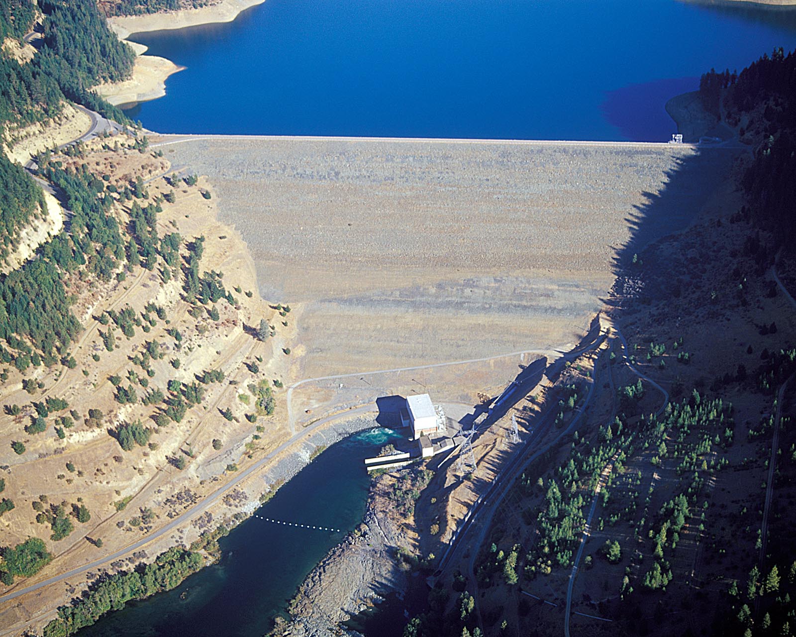
Today Trinity Dam rises 538 feet from its foundations, its crest stretching nearly half a mile long. The reservoir behind it can hold more than 2.4 million acre-feet of water encompassing over 145 miles of shoreline. At the dam's base, Trinity Powerplant houses two Francis turbines generating 140 megawatts combined, enough electricity to power roughly 100,000 homes. The plant generates an average of 359 million kilowatt hours annually, operating mainly as a peaking facility that ramps up during high-demand periods. Below Trinity, Lewiston Dam captures releases and diverts them through the tunnel to the Sacramento Valley, completing the system that transformed northwestern California's waters into Central Valley irrigation.
Recreation on Drowned Ground
Since 1965, Trinity Lake has been part of the Whiskeytown-Shasta-Trinity National Recreation Area. Marinas and boat ramps line the Stuart Fork arm in the southwest and cluster around the resort town of Trinity Center, rebuilt on higher ground after the original community was flooded. Summer brings Northern California residents seeking relief from valley heat, their boats tracing wakes over submerged streets and foundations. The irony is not lost on long-time locals. The lake that destroyed their communities now sustains their economy, drawing tourists to waters that cover the places their grandparents once called home.
From the Air
Trinity Dam sits at 40.80N, 122.76W in the rugged Klamath Mountains of northwestern California. The massive earthfill structure and Trinity Lake are clearly visible from altitude, with the distinctive morning-glory spillway on the left and powerhouse at the dam's base. Lewiston Lake lies just downstream. Nearest airports include Weaverville (O54) approximately 10nm southwest and Redding Municipal (RDD) about 45nm east. Best viewed at 5,000-8,000 feet AGL for full reservoir perspective.