Trinity Royal Heritage Conservation Area
Almost everything you see in the Trinity Royal Heritage Conservation Area was built in a hurry, by people who had just lost everything. The Great Fire of June 20, 1877, destroyed roughly 40 percent of Saint John's buildings and left 13,000 people homeless on the central peninsula. What rose in its place was not a cautious reconstruction but a defiant one: block after block of ornate Victorian brick buildings, many of them more elaborate than the wooden structures they replaced. The city designated this dense neighborhood as its first heritage conservation area in 1982, and today Trinity Royal holds six National Historic Sites within a few walkable blocks.
Born from Ashes
The 1877 fire changed the material vocabulary of Saint John overnight. Before the blaze, the city was largely built of wood, the abundant resource of a province covered in forest. After the fire, brick became the default. The buildings that went up in the Trinity Royal area during the late 1870s and 1880s reflect this shift. They are solidly Victorian in their ornament, with decorative cornices, arched windows, and patterned brickwork, but their construction was driven by a simpler imperative: they would not burn the way their predecessors had. The result is a neighborhood where architectural ambition and fire prevention are the same thing. Builders competed to show that Saint John could rebuild not just safely but beautifully.
Six National Historic Sites in One Neighborhood
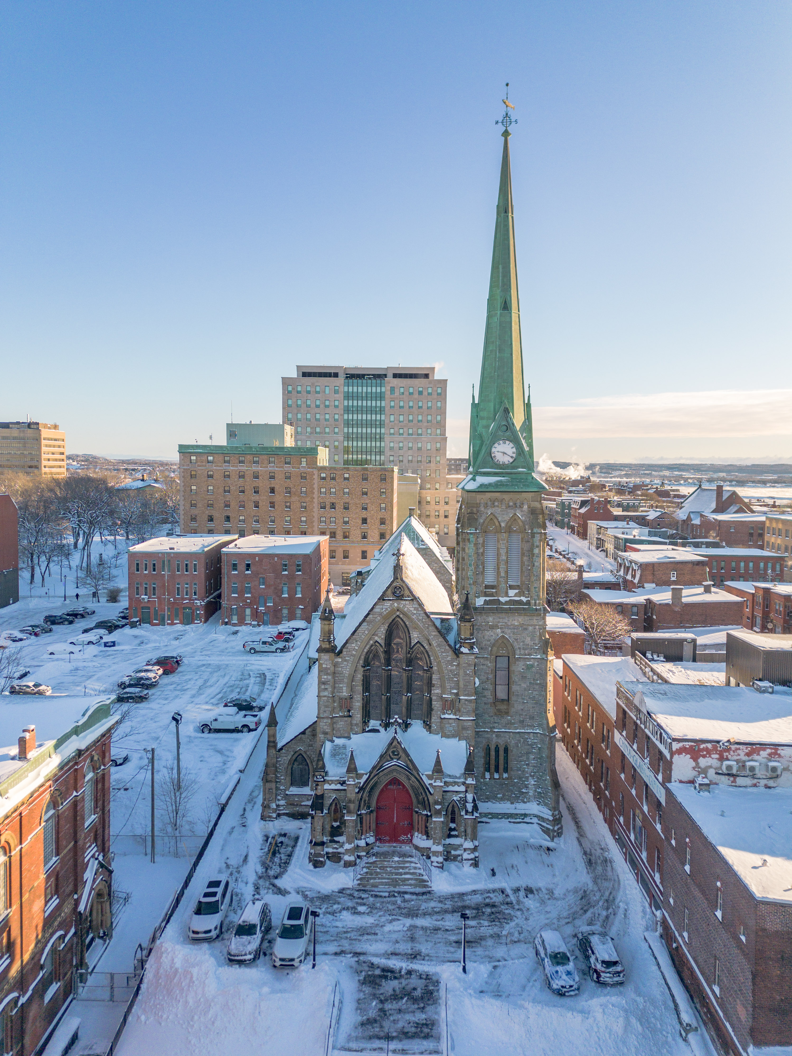
Walking through Trinity Royal, you pass an unusual concentration of nationally designated heritage sites. The Bank of New Brunswick Building, Trinity Anglican Church, the Imperial Theatre, Saint John County Courthouse, the Number 2 Mechanics' Volunteer Company Engine House, and the Prince William Streetscape all carry National Historic Site status. The effect is cumulative rather than monumental. No single building dominates. Instead, the district works because of the consistency of its Victorian streetscape, where commercial blocks, churches, and civic buildings create a cohesive urban fabric that has remained largely intact for nearly 150 years. The Imperial Theatre, restored in the 1990s, functions as a performing arts venue. The courthouse still serves its original purpose.
The Streets Between
The conservation area spans roughly twenty blocks bounded by King Street, Water Street, Queen Street, and Charlotte Street, with Sydney Street along its eastern edge. Within this tight grid, the streets have the character of a Victorian commercial district that never quite got around to modernizing. Prince William Street presents a continuous wall of ornate facades. Canterbury and Germain Streets hold shops, restaurants, pubs, and art galleries operating out of buildings that have not fundamentally changed since the 1880s. Green spaces punctuate the brick: the Loyalist Burial Ground, where headstones date to the city's founding, and Queen's Square and King's Square, the public parks that anchor the neighborhood's civic identity.
Preservation as Identity
Saint John's decision to establish Trinity Royal as a heritage conservation area in 1982 was not an act of nostalgia. It was a practical response to the kind of demolition-and-redevelopment pressures that had already reshaped many North American downtowns. The area has since expanded beyond its original boundaries. Within walking distance of the conservation area stand additional historic sites including the Saint John City Market, Loyalist House, and the Stone Church, creating a broader heritage precinct that draws cruise ship passengers docking at the nearby Water Street terminal. The district today houses a mix of commercial and residential uses, the kind of layered urban environment that cities spend billions trying to recreate but that Trinity Royal never lost. It endures because Saint John chose to protect it before it was gone.
From the Air
Located at 45.27N, 66.06W in the uptown core of Saint John, New Brunswick. The conservation area is identifiable from the air by its dense grid of Victorian brick buildings near the waterfront and cruise ship terminal on Water Street. Nearest airport is Saint John Airport (CYSJ), approximately 14 km east. The Saint John River mouth and Reversing Falls are visible to the northwest, and the Bay of Fundy stretches to the south.